King William, Virginia facts for kids
Quick facts for kids
King William, Virginia
|
|
|---|---|

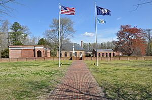
King William County Courthouse
|
|
| Country | United States |
| State | Virginia |
| County | King William |
| Area | |
| • Total | 4.6 sq mi (11.9 km2) |
| • Land | 4.6 sq mi (11.9 km2) |
| • Water | 0 sq mi (0.0 km2) |
| Elevation | 142 ft (43 m) |
| Population
(2010)
|
|
| • Total | 252 |
| • Density | 55/sq mi (21.1/km2) |
| Time zone | UTC−5 (Eastern (EST)) |
| • Summer (DST) | UTC−4 (EDT) |
| ZIP code |
23086
|
| FIPS code | 51-42792 |
| GNIS feature ID | 1498501 |
King William is a small community in Virginia, United States. It is a "census-designated place" (CDP). This means it's an area defined by the US Census Bureau for collecting information. King William is also the "county seat" of King William County. A county seat is the main town where the local government offices are located.
In 2010, the population of King William was 252 people. This community is home to the King William County Courthouse. This courthouse was built in 1725 and is the oldest one in the United States that is still being used today! You might also hear this place called King William Courthouse or King William Court House.
Several important historical places in King William are listed on the National Register of Historic Places. These include the King William County Courthouse, the King William Training School, the Sharon Indian School, and Sweet Hall.
Geography of King William
King William is located slightly east of the center of King William County. You can find it along Virginia State Route 30. It is about 17 miles (27 km) northwest of West Point. It is also about 31 miles (50 km) by road east of Richmond.
Land and Water Areas
According to the U.S. Census Bureau, King William covers an area of about 11.9 square kilometers (4.6 square miles). Almost all of this area is land. Only a tiny part, about 0.01%, is water. King William is located about 2 miles (3 km) south of Horse Landing. Horse Landing is a small community found on the tidal Mattaponi River.
Nearby Native American History
The Pamunkey Indian Reservation is located about 10 miles (16 km) south of King William. The Pamunkey Indian Tribe Museum was opened on this reservation in 1979. This museum helps share the history and culture of the Pamunkey people. Two important Native American chiefs, Wahunsonacock and Opechancanough, are buried on the Pamunkey Indian Reservation near the railroad tracks.
See also
 In Spanish: King William (Virginia) para niños
 | Emma Amos |
 | Edward Mitchell Bannister |
 | Larry D. Alexander |
 | Ernie Barnes |


