
Kingston, New Mexico facts for kids
Quick facts for kids
Kingston, New Mexico
|
|
|---|---|
|
Census-designated place
|
|

Kingston, New Mexico
|
|

Kingston, New Mexico
Location in New Mexico
|
|
| Country | United States |
| State | New Mexico |
| County | Sierra |
| Area | |
| • Total | 0.20 sq mi (0.52 km2) |
| • Land | 0.20 sq mi (0.52 km2) |
| • Water | 0.00 sq mi (0.00 km2) |
| Elevation | 6,240 ft (1,900 m) |
| Population
(2020)
|
|
| • Total | 50 |
| • Density | 251.26/sq mi (96.98/km2) |
| Time zone | UTC-7 (Mountain (MST)) |
| • Summer (DST) | UTC-6 (MDT) |
| Area code(s) | 575 |
| GNIS feature ID | 2584118 |
Kingston is a small community in Sierra County, New Mexico, United States. It is known as a census-designated place (CDP). In 2010, its population was 32 people. The community is found in the Black Range mountains, along New Mexico State Road 152.
Contents
History of Kingston
Kingston began in 1882 when Jack Sheddon found silver at what became the Solitaire Mine. The area was first called Percha City. Later that same year, Kingston was officially mapped out. Its population quickly grew to 1800 people. Even the famous singer Lillian Russell once performed here!
However, a big economic downturn called the Depression of 1893 caused mining activities to slow down a lot. There was a short time when mining picked up again during World War II. But by 1952, most of the mining in Kingston had stopped completely.
Geography of Kingston
Kingston is located at these coordinates: 32°55′02″N 107°42′34″W / 32.917334°N 107.709559°W. According to the U.S. Census Bureau, the community covers an area of about 0.199 square miles (0.52 square kilometers). All of this area is land.
Mining and Geology

After silver was found in a nearby area called Hillsboro, more silver was discovered in Kingston in 1880. Serious mining started in 1883. From 1883 to 1893, miners dug up almost 6 million ounces of silver from 27 different mines! Later, from 1934 to 1957, about 67,940 ounces of silver and 124 ounces of gold were also found.
Some of the first mines in the area were the Iron King, Empire, and Brush Heap. Most of the silver was found close to the surface, within 460 feet down. The silver was often in minerals like cerargyrite and native silver. From 1952 to 1959, miners also produced over 5,600 tons of manganese ore, mostly from the Iron King Mine. Manganese is a metal used in steel production.
The valuable minerals were usually found in cracks in the rocks called veins, which were created by major faults. These faults might be part of the edge of a large ancient volcano called the Emory Caldera. Most of these minerals formed in the Late Oligocene period, which was millions of years ago.
The Lady Franklin Mine was the biggest producer of high-quality silver. From 1880 to 1893, it produced silver that averaged 15 ounces per ton of rock.
Population Data
| Historical population | |||
|---|---|---|---|
| Census | Pop. | %± | |
| 2020 | 50 | — | |
| U.S. Decennial Census | |||
As of the 2020 census, the population of Kingston was 50 people.
Education
Students in Kingston attend schools managed by the Truth or Consequences Municipal Schools district. This district covers the entire county. Middle school students go to Truth or Consequences Middle School. High school students attend Hot Springs High School. Both schools are located in the town of Truth or Consequences.
Notable Person
- Edward L. Doheny
Gallery
-
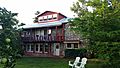
Black Range Lodge
-

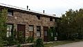
Former Percha Bank
-
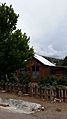
Former Victorio Hotel
-
Former Assay Office
-

Kingston's fire bell was also used to announce the arrival of mail.


See also
 In Spanish: Kingston (Nuevo México) para niños
