Kivalina River facts for kids
Quick facts for kids Kivalina River |
|
|---|---|

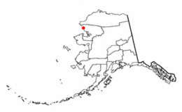
Location of Kivalina, Alaska
|
|
| Country | United States |
| State | Alaska |
| Borough | Northwest Arctic Borough |
| Physical characteristics | |
| Main source | De Long Mountains |
| River mouth | Kivalina Lagoon |
| Length | 60 miles (97 km) |
The Kivalina River is a river located in the northwestern part of Alaska, a large state in the United States. This river is about 60-mile-long (97 km), which is roughly 97 kilometers. It starts high up in the De Long Mountains and flows southwest. The river eventually empties into the Kivalina Lagoon, which then connects to the Chukchi Sea.
The small village of Kivalina is found right at the mouth of this river. It sits on a narrow strip of land, almost like a natural barrier reef.
Contents
Exploring the Kivalina River
The Kivalina River begins its journey in the De Long Mountains. These mountains are part of the larger Brooks Range in northern Alaska. From there, the river travels about 60 miles (97 kilometers) towards the coast.
Where the River Flows
As the Kivalina River flows, it passes through the beautiful Alaskan wilderness. Its waters eventually reach the Kivalina Lagoon. This lagoon is a protected body of water near the coast. From the lagoon, the river's waters mix with the vast Chukchi Sea. The Chukchi Sea is part of the Arctic Ocean.
The Village of Kivalina
The village of Kivalina has a close connection to the river. It is located right where the river meets the lagoon and the sea. The river has historically been important for the people living in the village. It provides a source of fresh water and is part of the local ecosystem.
A Bit of History
The Kivalina River has an interesting history regarding its name. In 1885, a United States Navy officer named Lieutenant G. M. Stoney recorded its Inuit name. He spelled it "Kuveleek." Later, in 1904, the spelling was officially changed to "Kivalina," which is what we use today.

