Kivalina, Alaska facts for kids
Quick facts for kids
Kivalina
Kivalliñiq
|
|
|---|---|

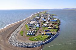
Aerial view of Kivalina
|
|

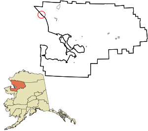
Location in Northwest Arctic Borough and the state of Alaska.
|
|
| Country | United States |
| State | Alaska |
| Borough | Northwest Arctic |
| Incorporated | June 23, 1969 |
| Area | |
| • Total | 4.16 sq mi (10.78 km2) |
| • Land | 1.63 sq mi (4.23 km2) |
| • Water | 2.53 sq mi (6.55 km2) |
| Elevation | 13 ft (4 m) |
| Population
(2020)
|
|
| • Total | 444 |
| • Density | 272.23/sq mi (105.08/km2) |
| Time zone | UTC-9 (Alaska (AKST)) |
| • Summer (DST) | UTC-8 (AKDT) |
| ZIP Code |
99750
|
| Area code | 907 |
| FIPS code | 02-39960 |
| GNIS feature ID | 1413348, 2419411 |
Kivalina (pronounced kiv-uh-LEE-nuh), also known as Kivalliñiq in the local language, is a small city and village in Northwest Arctic Borough, Alaska, United States. In 2020, about 444 people lived there.
Kivalina is located on a narrow island. This island is facing a big problem: it's being washed away by the ocean. This is happening because of climate change, which causes sea levels to rise and makes the coast wear away faster. Experts predicted that the island could be underwater by 2025. Because of these environmental challenges, Kivalina has been involved in several important court cases.
Contents
History of Kivalina
Kivalina is a community of the Inupiat, who are Native Alaskans. It was first mentioned in 1847. For a long time, it was a common stopping point for people traveling between the Arctic coast and communities around Kotzebue Sound. In 2009, ancient artifacts and three bodies were found here. They belonged to the Ipiutak culture, a group that lived here over a thousand years ago.
Kivalina is special because it's the only village in its region where people hunt the bowhead whale. The original village was once located at the northern end of the Kivalina Lagoon, but it was moved.
Around 1900, reindeer were brought to the area. Some people in Kivalina learned how to herd them.
In 1960, an airstrip was built in Kivalina, making it easier to travel to and from the village. Kivalina officially became a city in 1969. During the 1970s, a new school and an electric system were built, improving life for the residents.
On December 5, 2014, the only general store in Kivalina burned down. This was a big loss for the community. However, a new and improved store opened in July 2015 after months of hard work.
Geography and Location
Kivalina is located on the southern tip of a long, narrow strip of land called a barrier island. This island is about 12 kilometers (7.5 miles) long. It sits between the Chukchi Sea and a lagoon at the mouth of the Kivalina River. The village is about 130 kilometers (80 miles) northwest of Kotzebue.
The village covers a total area of about 10.1 square kilometers (3.9 square miles). About 4.9 square kilometers (1.9 square miles) of this is land, and the rest is water.
Climate in Kivalina
Kivalina has a dry subarctic climate. This means it has very long and cold winters, and short, cool summers. August is usually the wettest month, while December gets the most snow.
| Climate data for Kivalina, Alaska (Kivalina Airport) (1991-2020 normals, extremes 1998-present) | |||||||||||||
|---|---|---|---|---|---|---|---|---|---|---|---|---|---|
| Month | Jan | Feb | Mar | Apr | May | Jun | Jul | Aug | Sep | Oct | Nov | Dec | Year |
| Record high °F (°C) | 47 (8) |
52 (11) |
48 (9) |
62 (17) |
68 (20) |
96 (36) |
94 (34) |
89 (32) |
65 (18) |
58 (14) |
40 (4) |
39 (4) |
96 (36) |
| Mean maximum °F (°C) | 32.0 (0.0) |
34.4 (1.3) |
28.0 (−2.2) |
38.3 (3.5) |
54.4 (12.4) |
70.6 (21.4) |
72.0 (22.2) |
65.8 (18.8) |
57.5 (14.2) |
44.4 (6.9) |
32.0 (0.0) |
31.8 (−0.1) |
74.4 (23.6) |
| Mean daily maximum °F (°C) | 6.6 (−14.1) |
9.7 (−12.4) |
9.4 (−12.6) |
23.6 (−4.7) |
38.2 (3.4) |
50.0 (10.0) |
56.3 (13.5) |
54.5 (12.5) |
46.2 (7.9) |
30.5 (−0.8) |
17.3 (−8.2) |
10.0 (−12.2) |
29.4 (−1.5) |
| Daily mean °F (°C) | −1.2 (−18.4) |
1.3 (−17.1) |
0.9 (−17.3) |
14.8 (−9.6) |
32.1 (0.1) |
43.9 (6.6) |
50.9 (10.5) |
49.1 (9.5) |
40.6 (4.8) |
25.6 (−3.6) |
11.4 (−11.4) |
2.9 (−16.2) |
22.7 (−5.2) |
| Mean daily minimum °F (°C) | −9.0 (−22.8) |
−7.1 (−21.7) |
−7.6 (−22.0) |
6.0 (−14.4) |
25.9 (−3.4) |
37.8 (3.2) |
45.5 (7.5) |
43.7 (6.5) |
35.1 (1.7) |
20.6 (−6.3) |
5.5 (−14.7) |
−4.1 (−20.1) |
16.0 (−8.9) |
| Mean minimum °F (°C) | −33.2 (−36.2) |
−34.4 (−36.9) |
−28.6 (−33.7) |
−16.8 (−27.1) |
9.5 (−12.5) |
29.1 (−1.6) |
37.7 (3.2) |
34.6 (1.4) |
23.0 (−5.0) |
5.3 (−14.8) |
−15.1 (−26.2) |
−27.3 (−32.9) |
−39.9 (−39.9) |
| Record low °F (°C) | −50 (−46) |
−54 (−48) |
−41 (−41) |
−33 (−36) |
−9 (−23) |
21 (−6) |
33 (1) |
28 (−2) |
12 (−11) |
−8 (−22) |
−30 (−34) |
−41 (−41) |
−54 (−48) |
| Average precipitation inches (mm) | 0.28 (7.1) |
0.44 (11) |
0.18 (4.6) |
0.56 (14) |
0.57 (14) |
0.79 (20) |
1.41 (36) |
2.33 (59) |
1.52 (39) |
0.93 (24) |
0.51 (13) |
0.17 (4.3) |
9.69 (246) |
| Average precipitation days (≥ 0.01 in) | 5.3 | 5.3 | 3.0 | 4.7 | 6.4 | 6.1 | 11.7 | 13.0 | 11.5 | 8.1 | 5.7 | 4.1 | 84.9 |
| Source: NOAA | |||||||||||||
Population and Community Life
| Historical population | |||
|---|---|---|---|
| Census | Pop. | %± | |
| 1920 | 87 | — | |
| 1930 | 99 | 13.8% | |
| 1940 | 98 | −1.0% | |
| 1950 | 117 | 19.4% | |
| 1960 | 142 | 21.4% | |
| 1970 | 188 | 32.4% | |
| 1980 | 241 | 28.2% | |
| 1990 | 317 | 31.5% | |
| 2000 | 377 | 18.9% | |
| 2010 | 374 | −0.8% | |
| 2020 | 444 | 18.7% | |
| U.S. Decennial Census | |||
Kivalina first appeared in the U.S. Census in 1920. It officially became a city in 1969.
In 2010, there were 374 people living in Kivalina. Most of the people living there, about 96.55%, are Native American. The Native Village of Kivalina is a recognized tribe with its own elected council. The City of Kivalina also has an elected mayor and a city council.
Many households in Kivalina have children. In 2010, about 61.5% of households had children under 18. The average household had about 4.83 people. The median age in the village was 21 years old, meaning half the population was younger and half was older.
Environmental Challenges
Kivalina faces serious environmental problems, mainly from sea wave erosion during storms. The city hopes to move to a new location about 12 kilometers (7.5 miles) away. Studies are still being done to find the best new site.
The cost to move the entire village is very high. The U.S. Army Corps of Engineers estimated it could be between $95 million and $125 million. The Government Accountability Office (GAO) gave an even higher estimate, between $100 million and $400 million.
One big reason for the erosion is that the sea ice that used to protect the city from storms has disappeared. Without this ice, the coastline is much more exposed to powerful waves. This erosion and rising sea levels mean that people are losing their homes. Also, resources are becoming harder to find, which can lead to crowded living conditions and sanitation issues.
Legal Battles for Kivalina
Kivalina has taken legal action to address its environmental problems.
Kivalina vs. Big Oil Companies
In 2008, the city of Kivalina and the Native Village of Kivalina sued several large oil and power companies. They claimed that the huge amounts of greenhouse gases these companies released contributed to global warming, which threatened Kivalina's existence. The lawsuit asked for $400 million to help the village move. However, a federal court dismissed the case in 2009. The court decided that dealing with greenhouse gas emissions was a political issue for the government, not something for the courts to decide.
Kivalina vs. Teck Cominco
In 2004, Kivalina sued a Canadian mining company called Teck Cominco. Kivalina claimed the company was polluting its drinking water and harming fish by releasing mine waste into the Wulik River. In 2008, Teck Cominco settled the lawsuit. They agreed to build a pipeline to carry wastewater from the mine directly to the ocean, instead of into the river.
Kivalina vs. US EPA
In 2010, the Native Village of Kivalina sued the US Environmental Protection Agency (EPA). They argued that the EPA did not properly consider public concerns when approving the Red Dog Mine's waste discharge plan. In 2012, a court upheld the EPA's decision, saying the tribe's argument was not strong enough.
The Mystery of the Orange Goo
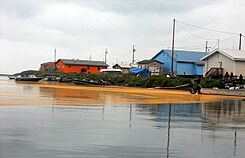
On August 4, 2011, people in Kivalina reported seeing a strange orange, gooey substance washing up on the shores. It also appeared in some residents' rain buckets. At first, tests suggested it might be millions of tiny crustacean eggs. However, officials later confirmed that the orange material was actually spores from a type of rust fungus called Chrysomyxa ledicola.
Sea Level Rise and Coastal Erosion
Kivalina has been flooded many times by storm surges, forcing residents to evacuate. Major floods happened in 1970, 1976, 2002, 2004, and a village-wide evacuation occurred in 2007. To help slow down the erosion, the US Army Corps of Engineers built a protective wall of rocks, called a rip-rap revetment, along the tip of the island and near the airport.
Other Climate Change Impacts
Besides increased flooding from storms, the erosion along the Wulik River also causes the water to become cloudy. This affects the city's drinking water source and makes it harder to treat the water.
Relocation Efforts
Because of the severe sea wave erosion during storms, the city hopes to move to a new site about 12 kilometers (7.5 miles) from its current location. In 2009, a government report identified Kivalina as one of 31 communities in Alaska threatened by environmental changes. Moving the village to higher ground off the barrier island has been a slow process.
In 2018, a decision was made to build an evacuation road across the Kivalina Lagoon. This road will provide a way for the community to escape during powerful storms that could flood the island. The road will also connect the village to the planned new school site on K-Hill.
Kivalina in the Media
Kivalina's environmental challenges have been featured in several documentaries and news stories. It was shown in "Alaska: State of Emergency," a 2015 documentary by The Weather Channel. Kivalina was also one of two towns featured in the Al Jazeera English Fault Lines documentary, When the Water Took the Land. The village's struggles were also explored in Kivalina, an hour-long documentary that was part of the PBS World series America ReFramed. In September 2019, The Atlantic magazine published a photo story about climate change in Kivalina called The Impact of Climate Change on Kivalina, Alaska.
Education in Kivalina
The McQueen School serves the community of Kivalina. It is managed by the Northwest Arctic Borough School District. In 2017, the school had 141 students, and all of them were Alaska Natives.
See also
 In Spanish: Kivalina (Alaska) para niños
- Kivalina Airport
 | James Van Der Zee |
 | Alma Thomas |
 | Ellis Wilson |
 | Margaret Taylor-Burroughs |


