
Kopaki railway station facts for kids
Quick facts for kids
Kopaki railway station
|
|||||||||||
|---|---|---|---|---|---|---|---|---|---|---|---|

Kopaki in 1957
|
|||||||||||
| Location | New Zealand | ||||||||||
| Coordinates | 38°28′42″S 175°16′24″E / 38.478387°S 175.273304°E | ||||||||||
| Elevation | 265 m (869 ft) | ||||||||||
| Line(s) | North Island Main Trunk | ||||||||||
| Distance | Wellington 454.62 km (282.49 mi) | ||||||||||
| History | |||||||||||
| Opened | 1 April 1901 | ||||||||||
| Closed | passengers before 12/1975 goods 31 January 1982 |
||||||||||
| Electrified | June 1988 | ||||||||||
| Previous names | Paritikona until 8 December 1912 | ||||||||||
| Services | |||||||||||
|
|||||||||||
Kopaki was a railway station located in the Waitomo District of New Zealand. It was on the North Island Main Trunk line, which is a very important railway route. Kopaki was known as a "flag station." This means trains would only stop there if someone put up a flag to get on, or if a passenger on the train asked to get off at Kopaki.
Contents
Building the Railway
The railway line through Kopaki was built as part of a bigger project. This project connected Puketutu to Poro-O-Tarao. Construction started in September 1892.
By January 18, 1897, a goods train began running once a week. This train carried items like farm products and supplies to Poro-O-Tarao.
Station Features and Changes
Over the years, Kopaki station saw several improvements.
- In 1920, a special yard was built for cattle. This made it easier to transport livestock by train.
- The station also had a "passing loop." This is an extra section of track that allows trains going in opposite directions to pass each other.
- In 1939, this passing loop was made much longer. It could then hold 219 wagons instead of just 97. This work cost about £19,000, which was a lot of money back then!
- The railway line just north of the station had a steep slope. It was a "1 in 70" gradient, meaning for every 70 meters forward, the track went up by 1 meter.
Local Businesses
Kopaki was a small but active place.
- In 1920, there was a Farmers Union store in Kopaki. This store likely sold supplies to local farmers.
- Later, in 1952, a sawmill was operating nearby. Sawmills cut timber into planks and other wood products.
The Kopaki post office was also close to the railway station. It was about 60 meters away.
Later Years and What Remains
By 1980, a report described the station as having a concrete block shelter shed. It also still had the passing loop, which could hold 121 wagons at that time.
Passenger trains stopped using Kopaki station before December 1975. Goods trains continued until January 31, 1982, when the station officially closed for freight.
Today, only the shelter shed and the passing loop remain at the site of the old Kopaki station.
Modern Bridge Project
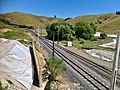
A bridge carrying SH30 goes over the railway line at Kopaki. This bridge was originally built from timber between 1925 and 1926.
Between 2021 and 2023, this old bridge is being replaced. The new bridge is designed to handle "high productivity vehicles." These are very large trucks that can carry more goods. The new bridge will be 68 meters long and cost about $12.4 million to build.
Images for kids
-
Construction of new SH30 bridge over Kopaki passing loop in 2022

