Koungou facts for kids
Quick facts for kids
Koungou
|
|
|---|---|
 |
|

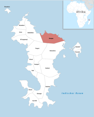
Location of the commune (in red) within Mayotte
|
|
| Country | France |
| Overseas region and department | Mayotte |
| Canton | Bandraboua and Koungou |
| Intercommunality | CA Grand Nord de Mayotte |
| Area
1
|
28.41 km2 (10.97 sq mi) |
| Population
(2017)
|
32,156 |
| • Density | 1,131.85/km2 (2,931.5/sq mi) |
| Time zone | UTC+03:00 |
| INSEE/Postal code |
97610 /97600
|
| 1 French Land Register data, which excludes lakes, ponds, glaciers > 1 km2 (0.386 sq mi or 247 acres) and river estuaries. | |
Koungou is a lively and growing area in Mayotte, a French overseas department located in the Indian Ocean. It's the second largest commune (like a town or district) in Mayotte, right after the capital city, Mamoudzou.
Koungou is made up of six different villages. These villages are Majicavo Lamir, Majicavo Koropa, Koungou itself, Trévani, Kangani, and Longoni. Each village adds to the unique feel of this special place.
Koungou's Growing Population
Koungou has seen a lot of growth in its population over the years. Many people have chosen to make Koungou their home, making it a busy and important part of Mayotte.
The number of people living in Koungou has increased quite a bit:
| Historical population | ||
|---|---|---|
| Year | Pop. | ±% p.a. |
| 1966 | 1,293 | — |
| 1978 | 2,362 | +5.15% |
| 1985 | 3,479 | +5.69% |
| 1991 | 6,046 | +9.65% |
| 1997 | 10,165 | +9.05% |
| 2002 | 15,383 | +8.64% |
| 2007 | 19,843 | +5.22% |
| 2012 | 26,488 | +5.95% |
| 2017 | 32,156 | +3.95% |
| Source: SPLAF (1966-2007) and INSEE (2012-2017) | ||
As you can see from the numbers, Koungou's population has grown from just over 1,000 people in 1966 to more than 32,000 by 2017. This shows how popular Koungou has become as a place to live and work.
See also
In Spanish: Koungou para niños
 | Kyle Baker |
 | Joseph Yoakum |
 | Laura Wheeler Waring |
 | Henry Ossawa Tanner |

