Kuélap facts for kids
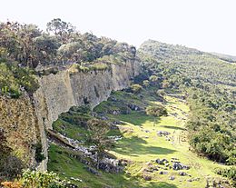
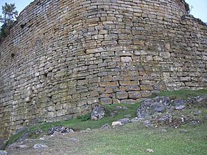
View of the city walls.
|
|
| Lua error in Module:Location_map at line 420: attempt to index field 'wikibase' (a nil value). | |
| Location | Luya Province, Amazonas |
|---|---|
| Type | Settlement |
| History | |
| Founded | 5th century AD - 1100 AD |
| Abandoned | 1532-1570 |
| Periods | Middle Horizon - Late Intermediate |
| Cultures | Chachapoya |
Kuélap, also spelled Cuélap, is an amazing ancient fortress. It's located high in the mountains of Amazonas, Peru. The Chachapoyas culture, an ancient civilization, built this walled city. They started building it around the 6th century AD. Kuélap sits on a ridge overlooking the Utcubamba Valley. It's a fantastic example of their advanced building skills.
Contents
Where is Kuélap?
Kuélap is found on a mountain ridge made of limestone. It's about 3,000 meters (9,842 feet) above sea level. This ancient site is located near the Utcubamba River. The area around Kuélap is a cloud forest. This means it's a misty, humid forest with many different trees. You can also find beautiful orchids and other plants called epiphytes growing on trees.
The protected area around Kuélap is quite large. It covers about 2.18 square kilometers (0.84 square miles). There's also a larger "buffer zone" of 6.10 square kilometers (2.36 square miles). These zones help protect Kuélap and other nearby ancient sites.
Amazing Architecture
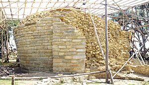
Kuélap is an abandoned city that covers about six hectares (14.8 acres). It stretches for 584 meters (1,916 feet) from north to south. At its widest, it is 110 meters (361 feet) across. The most striking feature of Kuélap is its massive walls. These walls are 10 to 20 meters (33 to 66 feet) high. They are made from huge limestone blocks. Some of these blocks can weigh up to 3 tons!
The city has three entrances. Two are on the east side, and one is on the west. The main entrance is shaped like a trapezoid. It gets narrower and narrower, so only one person can pass through at a time. This design likely helped protect the city.
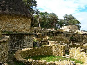
Most of the buildings inside Kuélap are circular. There are 421 structures in total, and only five of them are square or rectangular. Today, only the foundations or lower walls of these buildings remain. Some walls are still up to 2 meters (6.6 feet) high. Many walls have cool designs called friezes. These designs are shaped like diamonds (rhomboids) and zigzags. They are protected from the rain by special ledges called cornices. Some of these structures have been carefully rebuilt.
One special building is called El Tintero, which means "the inkwell" in Spanish. It's also known as the Templo Mayor (Main Temple). This structure is 5.5 meters (18 feet) tall and shaped like an upside-down cone. Archaeologists have found ceremonial items there. Some think it might have been used to study the sun.
In the northwest part of Kuélap is an area called Pueblo Alto (High Town). You enter it through two narrow openings in an 11.5-meter (38-foot) high wall. North of Pueblo Alto is a tower-like building called Torreón (Big Tower). It stands 7 meters (23 feet) tall. People think it was used for defense, as stone weapons have been found inside it.
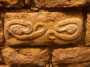
Many stones at Kuélap have carvings on them. These carvings show human shapes, animal shapes, and geometric patterns. Many burials have also been found. They were located both within the walls and inside the circular buildings.
The city also had stone canals. These canals probably brought water to the settlement from a spring higher up on the mountain.
History of Kuélap
Early History
People started living at the Kuélap site around the 5th century AD. However, most of the buildings you see today were built between 900 and 1100 AD. It's believed that about 3,000 people lived in this city.
The city was abandoned around 1570. This happened after the Spanish arrived in Peru. Over time, the city fell into disrepair and was covered by tree roots and plants.
Modern Discovery
Kuélap was accidentally rediscovered in 1843. A judge named Juan Crisóstomo Nieto from the city of Chachapoyas found it. After that, many explorers and researchers visited the site.
In 1870, Antonio Raimondi made a detailed survey of Kuélap. Charles Wiener visited in 1881. In 1939, French general Louis Langlois studied the site and wrote about its main buildings. Other archaeologists like Ernst Middendorf, Adolf Bandelier, Henry and Paule Reichlen, and Arturo Ruíz also studied Kuélap.
Since the 1980s, many Peruvian and international archaeologists have continued to explore and study Kuélap. Their work helps us learn more about this incredible ancient city.
How to Visit Kuélap
To get to Kuélap, you usually start from a town called El Tingo. It's about 1,800 meters (5,900 feet) above sea level. From El Tingo, you can take a cable car. The cable car takes you very close to the fortress, within 2 kilometers (1.2 miles). From there, visitors can walk or sometimes ride a horse the rest of the way. There's also a dirt road, but it's a longer journey. The cable car has made it much easier for people to visit this amazing historical site.
See also
 In Spanish: Kuélap para niños
- List of archaeological sites in Peru
- Gran Pajaten
- Iperu, tourist information and assistance
- Tourism in Peru


