Lérez facts for kids
Quick facts for kids Lérez |
|
|---|---|

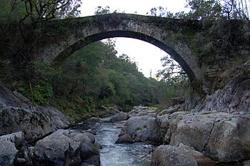
The Lérez river at San Xurxo de Sacos, Cotobade.
|
|
| Country | Spain |
| Autonomous Community | Galicia |
| City | Pontevedra |
| Physical characteristics | |
| Main source | San Bieito Forcarei, Pontevedra, Galicia, Spain 900 m (3,000 ft) |
| River mouth | Ria of Pontevedra, Spain 0 m (0 ft) 42°25′04″N 8°40′26″W / 42.417727°N 8.673988°W |
| Length | 60 km (37 mi) |
The Lérez River is an important river located in the southwest part of Galicia, Spain. It flows for about 60 kilometers (37 miles) before reaching the Atlantic Ocean at the city of Pontevedra. Here, the river forms a special inlet of the sea called a ria.
Contents
Where the River Starts and Flows
The Lérez River begins its journey high up in the Serra do Candán mountains. Its source is found on the mountain of San Bieito, in the parish of Aciveiro near Forcarei. From there, the river travels through several communities.
Towns Along the Lérez
As it flows, the Lérez River passes through different areas. These include the towns of Forcarei, Cerdedo, Campo Lameiro, and Cotobade. Finally, it reaches the city of Pontevedra, where it meets the sea.
Other Rivers Joining the Lérez
Many smaller rivers and streams join the Lérez along its path. These are called tributaries. The main ones that add water to the Lérez are the Salgueiro, Cabaleiros, Grande, O Castro, Quireza, Tenorio, and Almofrei rivers.
See also
 In Spanish: Río Lérez para niños
- List of rivers of Spain
- Rivers of Galicia
 | Victor J. Glover |
 | Yvonne Cagle |
 | Jeanette Epps |
 | Bernard A. Harris Jr. |

