
La Chapelle-Saint-Rémy facts for kids
Quick facts for kids
La Chapelle-Saint-Rémy
|
|
|---|---|
 |
|

La Chapelle-Saint-Rémy
Location in France

La Chapelle-Saint-Rémy
Location in Pays de la Loire
|
|
| Country | France |
| Region | Pays de la Loire |
| Department | Sarthe |
| Arrondissement | Mamers |
| Canton | La Ferté-Bernard |
| Intercommunality | Pays de l'Huisne Sarthoise |
| Area
1
|
19.20 km2 (7.41 sq mi) |
| Population
(Jan. 2019)
|
990 |
| • Density | 51.56/km2 (133.5/sq mi) |
| Demonym(s) | Capelloremyen, Capelloremyenne |
| Time zone | UTC+01:00 (CET) |
| • Summer (DST) | UTC+02:00 (CEST) |
| INSEE/Postal code |
72067 /72160
|
| Elevation | 64–151 m (210–495 ft) |
| 1 French Land Register data, which excludes lakes, ponds, glaciers > 1 km2 (0.386 sq mi or 247 acres) and river estuaries. | |
La Chapelle-Saint-Rémy is a small town or village in France. It is known as a commune in French. You can find it in the western part of France.
Contents
Discover La Chapelle-Saint-Rémy
La Chapelle-Saint-Rémy is a charming commune located in the Pays de la Loire region. This region is in the west of France. It is part of the Sarthe department.
What is a Commune?
In France, a commune is like a local government area. It can be a city, a town, or a village. La Chapelle-Saint-Rémy is one of many communes in France. Each commune has its own local government.
Where is La Chapelle-Saint-Rémy Located?
This commune is situated in the Sarthe department. The Sarthe department is named after the Sarthe River. It is known for its green landscapes and forests.
Geography and Surroundings
La Chapelle-Saint-Rémy is part of the Mamers arrondissement. An arrondissement is a type of administrative division in France. It helps organize local areas. The commune is also part of the La Ferté-Bernard canton. A canton is another way to divide areas for elections.
People and Life in the Commune
As of January 2019, about 990 people lived in La Chapelle-Saint-Rémy. People who live here are called Capelloremyen (for boys and men) or Capelloremyenne (for girls and women).
Local Government
The mayor of La Chapelle-Saint-Rémy is Olivier Durand. He was the mayor from 2008 to 2014. The mayor is the head of the local government. They help manage the town's services and represent its people.
Land and Elevation
The commune covers an area of 19.20 square kilometers. Its lowest point is 64 meters above sea level. The highest point reaches 151 meters. This means the land has some gentle hills.
Images for kids
-
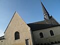
The church in La Chapelle-Saint-Rémy.
See also
 In Spanish: La Chapelle-Saint-Rémy para niños
