La Cumbre, Cáceres facts for kids
Quick facts for kids
La Cumbre, Spain
|
|||
|---|---|---|---|
|
municipality
|
|||

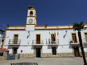
In front of a monument in La Cumbre, Cáceres
|
|||
|
|||

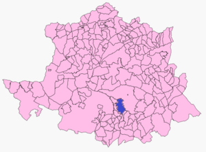
Map of La Cumbre, Cáceres
|
|||
| Country | Spain | ||
| Autonomous community | Extremadura | ||
| Province | Cáceres | ||
| Municipality | La Cumbre | ||
| Area | |||
| • Total | 113 km2 (44 sq mi) | ||
| Elevation | 480 m (1,570 ft) | ||
| Population
(2018)
|
|||
| • Total | 864 | ||
| • Density | 7.65/km2 (19.80/sq mi) | ||
| Time zone | UTC+1 (CET) | ||
| • Summer (DST) | UTC+2 (CEST) | ||
La Cumbre is a small town, also known as a municipality, located in the province of Cáceres. This province is part of Extremadura, one of Spain's regions.
In 2018, about 864 people lived in La Cumbre. The town covers an area of 113 square kilometers. It is located about 480 meters above sea level.
Contents
Where is La Cumbre?
La Cumbre is found in the western part of Spain. It is specifically in the Extremadura region. This region is known for its beautiful natural areas.
Location in Cáceres
The town is part of the Province of Cáceres. This province is one of the two provinces that make up Extremadura. Cáceres is a large province with many interesting places.
Population and People
La Cumbre is a small community. Its population was 864 people in 2018. The number of people living in a town can change over time.
How Population is Counted
Governments count how many people live in an area. This is called a census. It helps them understand communities better. The numbers for La Cumbre come from these official counts.
Time Zone
La Cumbre follows Central European Time (CET). This means it is one hour ahead of Coordinated Universal Time (UTC+1). During summer, they use Central European Summer Time (CEST). This is two hours ahead of UTC (UTC+2).
See also
 In Spanish: La Cumbre (Cáceres) para niños


