La Gloria, Veracruz facts for kids
Quick facts for kids
La Gloria
|
|
|---|---|
|
Town
|
|
| Country | |
| State | Veracruz |
| Municipality | Perote |
| Elevation | 2,460 m (8,070 ft) |
| Population
(2005)
|
|
| • Total | 2,243 |
| Time zone | UTC-6 (Central) |
| • Summer (DST) | UTC-5 (CDT) |
| Postal code |
91290
|
| Area code(s) | 282 |
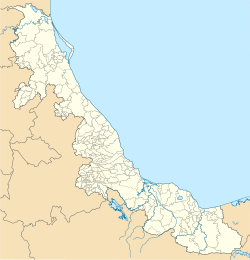
La Gloria is a small town in the municipality of Perote. It is located in the Mexican state of Veracruz. In 2005, about 2,243 people lived there.
Contents
Location and Geography
La Gloria is found in the Perote Valley. It is surrounded by tall mountains. The town is very high up, at about 2,460 meters (8,070 feet) above sea level. This makes it one of the highest places in Veracruz state.
Getting There
The town is located southwest of Cofre de Perote, a large mountain. It is about 40 kilometers (25 miles) from the city of Perote. A small highway connects La Gloria to Perote. This highway then meets Mexican Federal Highway 140, which goes to Xalapa.
Life in La Gloria
Many people who live in La Gloria also work in Mexico City. Mexico City is about 200 kilometers (124 miles) to the west. These workers often spend their weekdays in the city. They return to La Gloria on the weekends.
Local Industry and Concerns
Near La Gloria, there is a large farming operation called Granjas Carroll de Mexico. This farm raises many pigs. In 2008, it had almost 1,000,000 pigs. Some people in La Gloria have shared worries about this big pig farm.
Historical Note
La Gloria was mentioned in connection with the start of the 2009 H1N1 flu outbreak. Some people thought the flu might have begun near the town.
See also
 In Spanish: La Gloria (Veracruz) para niños


