La Paloma, Rocha facts for kids
Quick facts for kids
La Paloma
|
|
|---|---|
|
City
|
|
 |
|
| Country | |
| Department | |
| Founded | 1874 |
| Population
(2011 Census)
|
|
| • Total | 3,495 |
| Time zone | UTC -3 |
| Postal code |
27001
|
| Dial plan | +598 4479 (+4 digits) |
| Climate | Cfb |
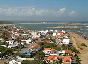
La Paloma is a charming coastal city located in the Rocha Department of southeastern Uruguay. It's a popular spot for tourists, especially during the summer months, known for its beautiful beaches and relaxed atmosphere. This city is a great place to enjoy the Atlantic Ocean and explore the natural beauty of the Uruguayan coast.
Contents
Where is La Paloma Located?
La Paloma sits right on the coast of the Atlantic Ocean. It is about 8 kilometers (5 miles) southwest of La Pedrera. The city is also about 53 kilometers (33 miles) northeast of Faro José Ignacio in the Maldonado Department. You can find it along Route 10, which is a main road that runs along the coast.
A Look at La Paloma's History
La Paloma was officially founded a long time ago, on September 1, 1874. It started as a small settlement. Over time, it grew bigger and more important.
How La Paloma Became a City
In 1939, La Paloma's status was changed to "Pueblo," which means "village" in Spanish. This was a step up from being just a small settlement. Then, in 1982, it was officially recognized as a "Ciudad," or "city." This shows how much La Paloma developed and grew over the years. During the 1940s, the area became more popular as a resort. Famous architect Juan Antonio Scasso helped design plans to expand the resort area.
Who Lives in La Paloma?
La Paloma is home to a friendly community. According to the 2011 census, the city had a population of 3,495 people. There were also 4,633 homes in the city at that time. The population has grown quite a bit over the years, especially as more people visit and move to this beautiful coastal area.
Population Growth Over Time
The number of people living in La Paloma has steadily increased. In 1963, there were only 818 residents. By 1985, the population had more than doubled to 2,235. This growth shows how La Paloma has become a more popular place to live and visit.
| Year | Population | Dwellings |
|---|---|---|
| 1963 | 818 | 716 |
| 1975 | 1,389 | 1,297 |
| 1985 | 2,235 | 1,686 |
| 1996 | 3,084 | 2,814 |
| 2004 | 3,202 | 3,583 |
| 2011 | 3,495 | 4,633 |
Images for kids
See also
 In Spanish: La Paloma (Rocha) para niños
 | Anna J. Cooper |
 | Mary McLeod Bethune |
 | Lillie Mae Bradford |


