La Place, Illinois facts for kids
Quick facts for kids
La Place
|
|
|---|---|
|
Census-designated place (CDP)
|
|
| Country | |
| State | |
| County | Piatt |
| Township | Cerro Gordo |
| Area | |
| • Total | 0.65 sq mi (1.69 km2) |
| • Land | 0.65 sq mi (1.69 km2) |
| • Water | 0.00 sq mi (0.00 km2) |
| Elevation | 705 ft (215 m) |
| Population
(2020)
|
|
| • Total | 239 |
| • Density | 366.00/sq mi (141.32/km2) |
| ZIP code |
61936
|
| FIPS code | 17-42067 |
| GNIS feature ID | 411659 |
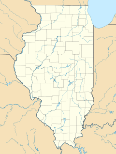
La Place is a small community in Piatt County, Illinois, United States. It is known as a census-designated place (CDP). This means it's an area that the government counts for the census, but it doesn't have its own local government like a city or town. It's also an unincorporated community, which means it's not officially part of any city.
La Place is located within Cerro Gordo Township. In 2010, about 259 people lived there.
Where is La Place Located?
La Place is found in the state of Illinois, in the United States. It sits at a specific point on the map: 39 degrees, 48 minutes, 0 seconds North, and 88 degrees, 43 minutes, 3 seconds West. The land in La Place is about 702 feet (214 meters) above sea level. This is how high it is compared to the ocean.
Who Lives in La Place?
The word "demographics" helps us understand the people who live in a place. It looks at things like how many people there are and how old they are.
| Historical population | |||
|---|---|---|---|
| Census | Pop. | %± | |
| 2020 | 239 | — | |
| U.S. Decennial Census | |||
According to the 2020 census, the population of La Place was 239 people. This number helps us see how the community has grown or changed over time.
See also
 In Spanish: LaPlace (Illinois) para niños
 | Stephanie Wilson |
 | Charles Bolden |
 | Ronald McNair |
 | Frederick D. Gregory |


