La Sierpe, Cuba facts for kids
Quick facts for kids
La Sierpe
|
|
|---|---|

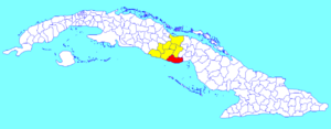
La Sierpe municipality (red) within
Sancti Spíritus Province (yellow) and Cuba |
|
| Country | Cuba |
| Province | Sancti Spíritus |
| Area | |
| • Total | 1,035 km2 (400 sq mi) |
| Elevation | 35 m (115 ft) |
| Population
(2022)
|
|
| • Total | 16,573 |
| • Density | 16.013/km2 (41.472/sq mi) |
| Time zone | UTC-5 (EST) |
| Area code(s) | +53-41 |
| Website | https://lasierpe.gob.cu/ |
La Sierpe is a town and a special area called a municipality in Sancti Spíritus Province, Cuba. It is located in the southeastern part of the province. The town is about 30 kilometers (19 miles) away from Sancti Spiritus, which is the capital city of the province.
Contents
Where is La Sierpe Located?
La Sierpe is on the southern coast of Cuba. It borders the Gulf of Ana Maria, which is part of the Caribbean Sea. To the east, it shares a border with the Ciego de Ávila Province.
This municipality is also very close to the exact middle of Cuba. This makes its location quite central within the country.
How Many People Live in La Sierpe?
In 2022, about 16,937 people lived in the municipality of La Sierpe. The total area of La Sierpe is about 1,035 square kilometers (400 square miles). This means that for every square kilometer, there are about 16 people living there.
Government and Leadership
Like other municipalities in Cuba, La Sierpe has its own local government. The person in charge is called the President. As of now, the President of La Sierpe is Yilián Díaz Meneses. The local government helps manage services and daily life for the people living in the municipality.
See also

- In Spanish: La Sierpe (Cuba) for children

