Laclede's Landing, St. Louis facts for kids
Quick facts for kids |
|
|
Laclede's Landing
|
|

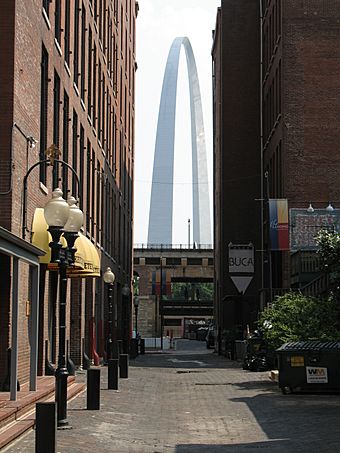
The Gateway Arch viewed from the Landing
|
|
| Lua error in Module:Location_map at line 420: attempt to index field 'wikibase' (a nil value). | |
| Location | Roughly bounded by Washington, N. 3rd, Dr. Martin Luther King Dr., and the Mississippi River, St. Louis, Missouri |
|---|---|
| Area | 22 acres (8.9 ha) |
| Built | 1780 |
| Architectural style | Late Victorian, Federal |
| NRHP reference No. | 76002262 |
| Added to NRHP | August 25, 1976 |
Laclede's Landing, often called "the Landing," is a cool historic area in St. Louis, Missouri, United States. It's where the city first started, founded by a French explorer named Pierre Laclède. The name "Laclede's Landing" remembers where he first landed by the river.
Even though the area was settled early, the buildings you see today are from later times. Most were built between 1850 and 1900. These old buildings used to be warehouses. Now, they are fun shops, restaurants, and places to hang out.
The Landing is right next to Gateway Arch National Park, just north of it. It sits along the Mississippi River. This area is special because it's the only part of St. Louis's old 19th-century riverfront that still looks like it did back then. It has cobblestone streets and buildings made of brick and cast iron.
Getting Around Laclede's Landing
Laclede's Landing has many streets paved with cobblestones. These are old, rounded stones used for roads. The area is very close to the Eads Bridge. This famous bridge crosses the Mississippi River.
You can also get to Laclede's Landing using public transportation. The St. Louis MetroLink is a train system that serves the St. Louis area. There's a special MetroLink stop called Arch-Laclede's Landing. This stop makes it easy to visit the area.

