Gateway Arch National Park facts for kids
Quick facts for kids Gateway Arch National Park |
|
|---|---|

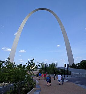
The Gateway Arch serves as the attraction's centerpiece.
|
|
| Location | St. Louis, Missouri, United States |
| Area | 192.83 acres (78.04 ha) |
| Established | February 22, 2018 |
| Visitors | 1,163,016 (in 2024) |
| Governing body | National Park Service |
| Website | |
|
Gateway Arch National Park
|
|
| Lua error in Module:Location_map at line 420: attempt to index field 'wikibase' (a nil value). | |
| Location | Mississippi River between Washington and Poplar Sts., St. Louis, Missouri |
| Area | 192.83 acres (78.04 ha) |
| Built | 1831–34 Old Cathedral 1839–64 Old Courthouse 1962–65 Gateway Arch |
| NRHP reference No. | 66000941 |
| Added to NRHP | October 15, 1966 |
The Gateway Arch National Park is a special national park of the United States located in St. Louis, Missouri. It sits near where the famous Lewis and Clark Expedition began their journey west. This park helps us remember important moments in American history.
It was first created in 1935 as a national memorial. It honored the Louisiana Purchase, which greatly expanded the United States. It also celebrated the brave explorers and pioneers who moved westward. The park also remembers the first government set up west of the Mississippi River. Finally, it marks the place of a very important legal case about human rights and freedom.
The park's main feature is the amazing Gateway Arch. This tall steel arch is a symbol of St. Louis. The park also includes a beautiful green space along the Mississippi River. This area is where the city's first buildings once stood. You can also visit the Old Courthouse, a historic building where that important legal case took place. Below the Arch, there is a large museum covering 140,000 sq ft (13,000 m2).
At 192.83 acres (78.04 ha), Gateway Arch National Park is the smallest national park in the United States. It is much smaller than most other national parks. The area around the Arch was first called the Jefferson National Expansion Memorial. The Gateway Arch itself was finished on October 28, 1965. The National Park Service (NPS) takes care of the park.
In 2018, the memorial became the Gateway Arch National Park. Some people discussed this change because national parks usually protect natural landscapes. This site is more about history and architecture. However, the new name aimed to attract more visitors to this important historical place.
Contents
Exploring Gateway Arch National Park
The Amazing Gateway Arch
The Gateway Arch is often called the "Gateway to the West." It is the tallest monument in the United States. A talented Finnish-American architect named Eero Saarinen designed it in 1947. He worked with German-American engineer Hannskarl Bandel. The Arch was built between 1963 and October 1965.
This incredible structure stands 630 feet (192 m) tall and is 630 feet (192 m) wide at its base. Its legs are 54 feet (16.5 m) wide at the bottom. They become narrower, reaching 17 feet (5.2 m) at the very top. Inside, a special tram system carries visitors to an observation room. From there, you can see amazing views from the top of the Arch!
The Historic Old Courthouse
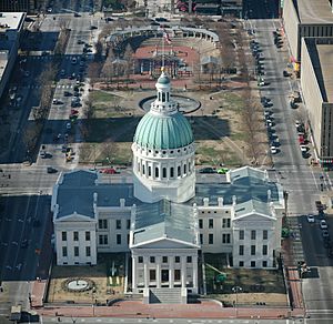
The Old Courthouse stands on land given by Auguste Chouteau, a founder of St. Louis. It is located right where the Arch begins its curve. Its impressive dome was built during the American Civil War. This dome looks similar to the one on the United States Capitol building.
This courthouse was the location for important local trials. One of the most famous was a legal case about human rights and freedom. The Old Courthouse is the only part of the park west of Interstate 44.
The Gateway Arch Museum
Underneath the Arch, you will find a modern visitor center. It has a circular entrance that faces the Old Courthouse. In July 2018, a big project to update the Museum at the Gateway Arch was finished.
The new museum has many exciting exhibits. You can learn about the westward expansion of America. You can also discover how the amazing Arch was built. Everything is shown through the history of St. Louis. The Tucker Theater, updated in 1998, seats about 285 people. It shows a documentary called Monument to the Dream about the Arch's construction. The visitor center also has a gift shop and a cafe.
History of the Gateway Arch Park
How the Idea Began in the 1930s
The idea for this special memorial came mostly from a St. Louis leader named Luther Ely Smith. In 1933, he suggested creating a monument. He later became the chairman of the committee that chose the park's location. In 1935, he convinced President Franklin Roosevelt to make it a unit of the National Park Service. St. Louis helped by raising money to start the project.
In the early 1930s, America wanted a new memorial for Thomas Jefferson. At that time, only the Washington Monument and Lincoln Memorial honored presidents in a big way.
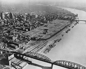
After Thanksgiving in 1933, Mr. Smith was on a train. He noticed how run-down the original St. Louis riverfront looked. He believed a memorial to Jefferson should be right there. This spot was important because it symbolized Jefferson's greatest achievement: the Louisiana Purchase.
The original area of St. Louis was historically significant. It was the site of the Battle of St. Louis during the American Revolutionary War. This was the only battle west of the Mississippi River. It was also the first capital of Upper Louisiana for the United States. In 1804, a special "Three Flags Day" ceremony happened here. Spain gave Louisiana to France, and then France quickly gave it to the United States. This completed the Louisiana Purchase. It also allowed Meriwether Lewis and William Clark to legally begin their exploration of the western lands.
Most of the old buildings from this period had been replaced. Mr. Smith's idea was to clear these buildings. He wanted to create a park with a central feature, like an arch. This arch would symbolize American culture and progress.
Mr. Smith shared his idea with Bernard Dickmann, a St. Louis mayor. On December 15, 1933, city leaders met and supported the plan. Mr. Smith became the chairman of the Jefferson National Expansion Memorial Association.
The committee estimated it would cost $30 million to buy the land, clear buildings, and build the park. The federal government promised to help if St. Louis could raise some money.
The park area was planned to be between the Eads Bridge and Poplar Street. It stretched from the Mississippi River to Third Street (now Interstate 44). The Old Courthouse was added to the plan in 1940.
The only building in this area that was not removed was the Old Cathedral. This church stands on the site of St. Louis's first church. The city's founders were buried in its graveyard.
Clearing 40 blocks in downtown St. Louis was a big and debated decision. On September 10, 1935, St. Louis voters approved a $7.5 million bond issue to buy the property. However, there were some disagreements about how the land was acquired. The federal government bought the buildings for $7 million. President Roosevelt visited the memorial area on October 14, 1936.
Designing the Arch in the 1940s
The land was cleared by 1942. Many old buildings were removed, including homes of early fur traders and pioneers. The architectural competition for the monument was delayed by World War II. After the war, interest grew, as it would be one of the first major monuments built in the new era.
The competition cost $225,000, with Mr. Smith personally donating $40,000. In 1947, a nationwide competition was held to choose a design. Architect Eero Saarinen won with his plans for a 590-foot (180 m) arch. It was to be placed on the banks of the Mississippi River. Over the next 15 years, these plans were adjusted. The Arch was placed on higher ground and made 40 feet (12 m) taller and wider.
The Old Courthouse is a key feature near the Arch's base. It was once the tallest building in Missouri. Its dome, built during the American Civil War, looks like the one on the United States Capitol.
Saarinen worked with engineer Hannskarl Bandel to create the Arch's unique shape. It's not a perfect curve. Saarinen wanted it to look slightly stretched and thinner at the top. This design makes it seem to soar upwards.
When Saarinen won, the official notice went to "E. Saarinen." They thought it was his father, Eliel Saarinen, who was also an architect and had entered the contest. The family celebrated. Two hours later, an official called to say the younger Saarinen had won. His father then opened a second bottle of champagne to celebrate his son's success!
Building the Arch in the 1950s and 1960s
The land for the memorial was officially dedicated on June 10, 1950, by President Harry S. Truman. However, the Korean War began, and the project was put on hold.
On June 23, 1959, work started on covering railroad tracks that crossed the memorial grounds. This was an important step to prepare the site.
On February 11, 1961, excavation for the Arch began. Sadly, Saarinen passed away that September 1. On February 12, 1963, the first stainless steel triangle section of the Arch was put in place.
The Arch was completed on October 28, 1965. It cost about $15 million to build. Landscape architect Dan Kiley designed the park around it. The memorial was added to the National Register of Historic Places on October 15, 1966. Vice President Hubert Humphrey and Secretary of the Interior Stewart Udall dedicated the Arch on May 25, 1968.
Later Developments: 1980s to 2000s
In 1984, Congress allowed the memorial to expand. It could include up to 100 acres (40 ha) on the east bank of the Mississippi River in East St. Louis, Illinois. Funds were approved to buy land. However, Congress later stopped new land purchases for national parks in 1998. This expansion became less likely due to other developments in the area.
During the Great Flood of 1993, the Mississippi River waters reached halfway up the Grand Staircase on the east side of the Arch.
In 1999, the Arch tram waiting areas were updated. This renovation cost about $2.2 million. Also, the Ulysses S. Grant National Historic Site in St. Louis County, Missouri, became part of the memorial's management.

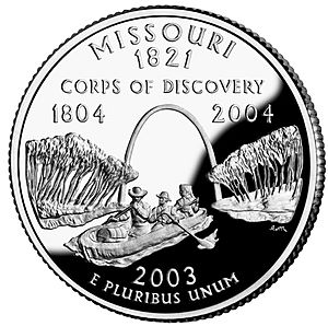
The Arch was featured on the Missouri state quarter in 2003. In 2007, St. Louis Mayor Francis Slay and former Senator John Danforth asked the National Park Service to make the memorial grounds more active. They suggested adding things like fountains and ice skating. The National Park Service was cautious about these ideas.
Modern Renovations and Redesignation in the 2010s
Park Renovations
For many years, the memorial was separated from downtown St. Louis by a sunken highway. In 2014, a "lid" was built over the highway. This created a foundation for a new park. It connected downtown with the Arch grounds. In November 2015, Saarinen's original vision for the park was completed. A connector linking the Old Courthouse to the Arch grounds was finished.
These designs were created by Michael Van Valkenburg Associates. In September 2010, they won a contest to redesign the visitor experience. The project was finished in 2018. It included:
- Replacing a parking garage with an outdoor amphitheater.
- Adding an explorers garden for children.
- Creating 7.5 acres of new green space.
- Building a new cobblestone plaza between the Arch and the river.
- Constructing elevated walkways on the Illinois side, winding through a new bird sanctuary.
- Expanding the museum below the Gateway Arch with a new western entrance.
In 2016, many ash trees were removed to protect against tiny insects called emerald ash borers. Before the project, there were 1,800 trees. Now, there are 4,200 trees on the grounds.
The entire project cost $380 million. Public funds, mostly from Proposition P, provided $159 million. The Gateway Arch Park Foundation raised the remaining $221 million.
Becoming a National Park
 |
|
| Long title | An Act to redesignate the Jefferson National Expansion Memorial in the State of Missouri as the "Gateway Arch National Park". |
|---|---|
| Enacted by | the 115th United States Congress |
| Effective | February 22, 2018 |
| Citations | |
| Public law | Pub.L. 115-128 |
| Statutes at Large | 132 Stat. 328 |
| Codification | |
| Titles amended | 16 U.S.C.: Conservation |
| U.S.C. sections created | 16 U.S.C. § 450jj-10 |
| Legislative history | |
|
|
On June 26, 2017, Senator Roy Blunt (R-Missouri) introduced a bill. It proposed changing the name of Jefferson National Expansion Memorial to Gateway Arch National Park. Senator Claire McCaskill (D-Missouri) also supported this bill.
In July 2017, Robert Vogel from the National Park Service spoke about the change. He suggested calling it "Gateway Arch National Monument" instead of "National Park." He explained that national parks usually cover thousands of acres of natural landscapes. He felt the memorial was too small for the "national park" name.
However, the United States Congress approved the bill in early 2018. President Donald Trump signed it into law on February 22, 2018. This officially renamed the site Gateway Arch National Park.
Many saw this new name as a way to boost tourism in St. Louis. Some visitors, however, felt the name was not quite right for a historical site.
Brickline Greenway Project
The Brickline Greenway, once called the Chouteau Greenway Project, is a team effort. It aims to connect Forest Park and Washington University in St. Louis to Gateway Arch National Park. Partners like the Arch to Park Collaborative, St. Louis City, and Washington University are leading this project.
See also
 In Spanish: Parque nacional Gateway Arch para niños
 | Tommie Smith |
 | Simone Manuel |
 | Shani Davis |
 | Simone Biles |
 | Alice Coachman |


