Laflin, Missouri facts for kids
Quick facts for kids
Laflin, Missouri
|
|
|---|---|

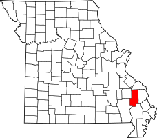
Location of Bollinger County, Missouri
|
|
| Country | United States |
| State | Missouri |
| County | Bollinger |
| Township | Lorance |
| Elevation | 400 ft (122 m) |
| Time zone | UTC-6 (Central (CST)) |
| • Summer (DST) | UTC-5 (CDT) |
| Area code(s) | 573 |
Laflin is a small, quiet place in Missouri, United States. It's called an unincorporated community, which means it doesn't have its own local government like a city or town. Laflin is located in the southeastern part of Lorance Township in Bollinger County.
This community is found on the flat land near Crooked Creek. You can reach Laflin by following Missouri Route U until the very end. The town of Marble Hill is about 4.5 miles (7.2 kilometers) away to the northwest.
History of Laflin
The community of Laflin was named after a man named Sylvester M. Laflin. At the time, he was a director for the Belmont Branch of the St. Louis and Iron Mountain Railroad.
Laflin was once a very important place for shipping timber by train. Trees cut down in the area would be sent from here to other places. A post office, where people could send and receive mail, was open in Laflin for many years, from 1871 until 1954.
 | Misty Copeland |
 | Raven Wilkinson |
 | Debra Austin |
 | Aesha Ash |

