Marble Hill, Missouri facts for kids
Quick facts for kids
Marble Hill, Missouri
|
|
|---|---|

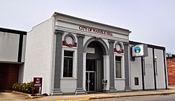
Marble Hill City Hall, April 2014.
|
|

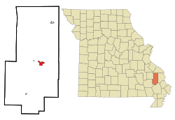
Location of Marble Hill, Missouri
|
|
| Country | United States |
| State | Missouri |
| County | Bollinger |
| Government | |
| • Type | Mayor-Council |
| Area | |
| • Total | 1.66 sq mi (4.30 km2) |
| • Land | 1.65 sq mi (4.28 km2) |
| • Water | 0.01 sq mi (0.01 km2) |
| Elevation | 400 ft (100 m) |
| Population
(2020)
|
|
| • Total | 1,388 |
| • Density | 839.18/sq mi (323.93/km2) |
| Time zone | UTC-6 (Central (CST)) |
| • Summer (DST) | UTC-5 (CDT) |
| ZIP code |
63764
|
| Area code(s) | 573 |
| FIPS code | 29-45848 |
| GNIS feature ID = | 2395000 |
Marble Hill is a city in central Bollinger County, in Southeast Missouri, United States. It's located where Highway 34 and Highway 51 meet. Marble Hill is the biggest city in Bollinger County and is also its county seat (the main town where the county government is). In 2020, about 1,388 people lived there. The city started in July 1851 and got its name from a rock that looked like marble. Marble Hill is part of a larger area called the Cape Girardeau-Jackson Metropolitan Area.
Contents
History of Marble Hill
The area now known as Marble Hill began in 1842 as "New California." Nine years later, in 1851, it was renamed "Dallas." As the town grew, the First Baptist Church was built in 1856. In 1862, during the American Civil War, Confederate soldiers raided the courthouse and town of Dallas. In 1868, the town's name changed again to Marble Hill. This was to avoid confusion with an existing Dallas County in Missouri.
Railroad and Town Growth
In 1869, a man named Eli Lutes planned a new town nearby, which became Lutesville. Lutes offered land to the railroad for a depot. This depot would be a place for shipping and trading goods. Because of disagreements with leaders in Marble Hill, the railroad decided to build its route through Lutesville instead.
In 1880, Will Mayfield College moved to Marble Hill. It stayed open until 1934. Other important buildings appeared, like Wicecarver's Store in 1893. A special "Mineral Well" was dug on the courthouse square between 1904 and 1905. It was used until the late 1940s. The last passenger train line stopped running through Lutesville in 1932. The railroad completely stopped operations there in 1973.
Modern Developments
In 1953, a deep artesian well was found while drilling for oil. In 1973, people voted to build the Twin City Airport. In 1985, the towns of Marble Hill and Lutesville decided to join together. Lutesville had become a major business center. However, the combined town kept the name Marble Hill because it was the county seat. The part of Marble Hill that used to be Lutesville is southwest of Crooked Creek. This creek has caused floods in the town many times.
Education in Marble Hill
Many adults in Marble Hill have finished high school. About 40% of adults aged 25 and older have a high school diploma. Some also have college degrees.
Public Schools
Most students in Marble Hill attend schools in the Woodland R-IV School District. This district serves students throughout central Bollinger County. The district has one elementary school, one middle school, and one high school.
- Woodland Elementary School (Kindergarten to 4th grade)
- Woodland Middle School (5th to 8th grade)
- Woodland High School (9th to 12th grade)
The school colors are red and black, and their mascot is the cardinal. Students can participate in sports like basketball, cross country, baseball, volleyball, softball, and cheerleading.
Public Library
Marble Hill also has its own public library, called the Bollinger County Library. It's a great place to find books and learn new things.
Geography and Location
Marble Hill is located just north of where two creeks meet: Hurricane Creek and Crooked Creek. The town of Lutesville is just south of Marble Hill, across Crooked Creek. Highway 34 and Highway 51 both pass through the community.
The city covers a total area of about 1.65 square miles (4.27 square kilometers). Most of this area is land, with a very small amount of water.
Climate
Marble Hill has a humid subtropical climate. This means it has hot and humid summers. The winters are generally cool. There is a lot of rain throughout the year, with an average of about 48.58 inches (1234 mm) annually. Spring and autumn are usually the wettest seasons.
| Climate data for Marble Hill, Missouri | |||||||||||||
|---|---|---|---|---|---|---|---|---|---|---|---|---|---|
| Month | Jan | Feb | Mar | Apr | May | Jun | Jul | Aug | Sep | Oct | Nov | Dec | Year |
| Mean daily maximum °F (°C) | 43 (6) |
50 (10) |
60 (16) |
70 (21) |
78 (26) |
85 (29) |
89 (32) |
88 (31) |
82 (28) |
72 (22) |
58 (14) |
47 (8) |
69 (20) |
| Mean daily minimum °F (°C) | 22 (−6) |
26 (−3) |
35 (2) |
43 (6) |
53 (12) |
61 (16) |
66 (19) |
63 (17) |
56 (13) |
43 (6) |
35 (2) |
26 (−3) |
44 (7) |
| Average precipitation inches (mm) | 3.23 (82) |
3.18 (81) |
4.91 (125) |
4.58 (116) |
4.59 (117) |
4.21 (107) |
4.20 (107) |
3.60 (91) |
3.54 (90) |
3.37 (86) |
4.85 (123) |
4.32 (110) |
48.58 (1,234) |
Population Facts
The population of Marble Hill has changed over the years.
| Historical population | |||
|---|---|---|---|
| Census | Pop. | %± | |
| 1880 | 265 | — | |
| 1890 | 257 | −3.0% | |
| 1900 | 295 | 14.8% | |
| 1910 | 313 | 6.1% | |
| 1920 | 332 | 6.1% | |
| 1930 | 421 | 26.8% | |
| 1940 | 421 | 0.0% | |
| 1950 | 454 | 7.8% | |
| 1960 | 497 | 9.5% | |
| 1970 | 589 | 18.5% | |
| 1980 | 601 | 2.0% | |
| 1990 | 1,447 | 140.8% | |
| 2000 | 1,502 | 3.8% | |
| 2010 | 1,477 | −1.7% | |
| 2020 | 1,388 | −6.0% | |
| U.S. Decennial Census | |||
2010 Census Information
According to the census from 2010, there were 1,477 people living in Marble Hill. These people lived in 604 households, with 369 of them being families. The city had about 900 people per square mile. Most of the people living in Marble Hill were White (96.41%).
About 24.8% of the residents were under 18 years old. About 20.9% were 65 years old or older. The average age in the city was 39.8 years. More females lived in the city (56.6%) than males (43.4%).
See also
 In Spanish: Marble Hill (Misuri) para niños
 | Kyle Baker |
 | Joseph Yoakum |
 | Laura Wheeler Waring |
 | Henry Ossawa Tanner |

