Lutesville, Missouri facts for kids
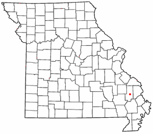
Lutesville was once a small city located in Bollinger County, Missouri, in the United States. It was very close to another city called Marble Hill. Lutesville was situated southwest of Marble Hill, right along Route 51 and Route 34. A stream called Crooked Creek flowed between Lutesville and Marble Hill, and Opossum Creek flowed nearby to the south.
Contents
History of Lutesville
How Lutesville Began
Lutesville was established in 1869. It was planned out to be a city because a new train station, or "depot," for the St. Louis, Iron Mountain and Southern Railway was going to be built there. The city was named after its founder, a man named Eli Lutes.
The Railroad and Its End
For many years, the railroad was an important part of Lutesville. It helped the city grow and connect with other places. However, the trains stopped running through Lutesville in 1973. This change affected the city quite a bit.
Merging with Marble Hill
In 1985, something big happened for Lutesville. It joined together with its neighbor, Marble Hill, to become one single city. The combined city kept the name Marble Hill. So, Lutesville, which used to be a busy and growing place, became a part of Marble Hill from that time on.
Post Office and Cemetery
Before it merged, Lutesville had its own post office. This post office closed in 1992. The Zip code for Lutesville was 63762. Today, a place called Dry Creek Cemetery is still located in the area that was once Lutesville.
 | Jackie Robinson |
 | Jack Johnson |
 | Althea Gibson |
 | Arthur Ashe |
 | Muhammad Ali |


