Lake Rotokawau (Bay of Plenty) facts for kids
Quick facts for kids Lake Rotokawau |
|
|---|---|

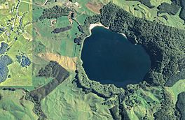
Aerial view of Lake Rotokawau in 2018
|
|
| Location | Bay of Plenty, North Island |
| Coordinates | 38°04′24″S 176°22′46″E / 38.07331°S 176.37935°E |
| Type | maar lake |
| Primary inflows | Waimata Stream |
| Primary outflows | Waiohewa Stream |
| Catchment area | 2.23 km2 (0.86 sq mi) |
| Basin countries | New Zealand |
| Surface area | 0.52 km2 (0.20 sq mi) |
| Average depth | 43.7 m (143 ft) |
| Max. depth | 74 m (243 ft) |
| Surface elevation | 320 m (1,050 ft) |
Lake Rotokawau is a small lake in the Bay of Plenty region of New Zealand's North Island. It is about 4.1 km (2.5 mi) east of Lake Rotorua. The name "Rotokawau" is also used for a few other lakes in New Zealand, but this article is about the one near Rotorua.
You can get to Lake Rotokawau by taking Lake Rotokawau Road from SH30 at a place called Tikitere. The lake is special because it is owned and looked after by the local Māori people, Ngāti Rangiteaorere.
What Kind of Lake is Rotokawau?
Lake Rotokawau is a unique type of lake called a maar lake. This means it was formed by a huge volcanic explosion! About 4,000 years ago, a powerful blast created a big crater. Over time, this crater filled with water, forming the lake we see today.
The land around the lake still shows signs of this explosion. There are cliffs up to 90 m (300 ft) high surrounding the water. The rocks nearby are made of rhyolite and pumice, which are types of volcanic rock. There are also areas with sand and silt.
How the Lake Stays Healthy
Lake Rotokawau is known as an oligotrophic lake. This is a fancy word that means its water is very clear and clean, with low levels of nutrients. It's a great example of how many of the deep lakes in the Rotorua area used to be.
The lake gets its water from the Waimata Stream, which flows in from the south. It also has small hot springs on its north-west side. The water leaves the lake by flowing underground into the Waiohewa Stream, near Tikitere.
The land around the lake is important for its health. About 65% of the area is covered in forest, which helps keep the water clean. The other 25% is used for farming.
Amazing Animals of Lake Rotokawau
Lake Rotokawau is home to many interesting native fish. These fish are an important part of the lake's ecosystem.
Some of the fish you might find living in the lake include:
- Koaro (Galaxias brevipinnis)
- Banded kokopu (Galaxias fasciatus)
- Long-finned eel (Anguilla dieffenbachia)
- Short-finned eel (Anguilla australis)
- Smelt (Retropinna retropinna)
- Common bully (Gobiomorphus cotidianus)
These fish are all native to New Zealand and play a vital role in the lake's natural balance. Protecting their home helps keep the lake healthy for future generations.


