Landsat Island facts for kids
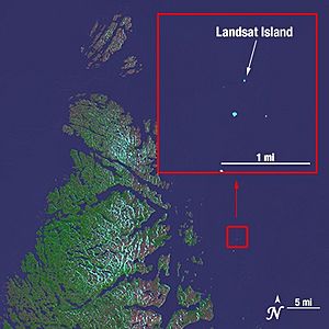
Landsat Island is a very small, empty island located off the northeast coast of Labrador, which is part of Newfoundland and Labrador, Canada. It's only about 20 kilometers (12 miles) from the mainland. This tiny island is just 25 meters (82 feet) wide and 45 meters (148 feet) long. That's about the size of a small house! It was first seen in 1976 using pictures from a special satellite called Landsat 1.
How Landsat Island Was Discovered
In 1976, Canadian experts were mapping the coast using information from the Landsat 1 satellite. This satellite takes detailed pictures of Earth from space. When they looked at these pictures, they found some places that no one had ever mapped before. One of these new places was Landsat Island. They decided to name it after the satellite that helped them find it.
To make sure the island was really there, a scientist named Dr. Frank Hall from the Canadian Hydrographic Service had to go visit it.
The Exciting Polar Bear Encounter
Dr. Hall had an amazing adventure when he went to check on the island. He was strapped into a harness and lowered from a helicopter down to the island. It was a very cold and icy place. As he was being lowered, a polar bear suddenly tried to hit him! The bear was on the highest part of the island and was hard to see because its fur was white like the ice. Dr. Hall quickly pulled his cable and was lifted back into the helicopter. He later said he almost became the first person to end his life on Landsat Island!
After Dr. Hall's close call with the polar bear, some people thought the island should be called "Polar Island." But the name Landsat Island was kept.
Finding Landsat Island was important for Canada. It marked the country's easternmost point along that part of the Labrador coast. Because of this discovery, Canada's ocean territory grew by about 68 square kilometers (26 square miles).
 | Victor J. Glover |
 | Yvonne Cagle |
 | Jeanette Epps |
 | Bernard A. Harris Jr. |


