
Laura to Maytown Coach Road facts for kids
Quick facts for kids Laura to Maytown Coach Road |
|
|---|---|
.jpg)
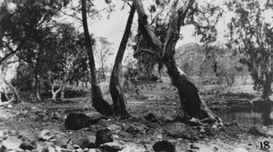
1895 descent & cutting
|
|
| Location | Laura to Maytown, Shire of Cook, Queensland, Australia |
| Design period | 1870s - 1890s (late 19th century) |
| Built | c. 1877 - c. 1895 |
| Official name: Laura to Maytown Coach Road | |
| Type | state heritage (built, archaeological) |
| Designated | 21 October 1992 |
| Reference no. | 600427 |
| Significant period | c. 1877-c. 1895 (fabric, route formation) |
| Significant components | cutting - road, drainage |
| Lua error in Module:Location_map at line 420: attempt to index field 'wikibase' (a nil value). | |
The Laura to Maytown Coach Road is an old road in Queensland, Australia. It connects the towns of Laura and Maytown. This road was built between about 1877 and 1895. It is now protected as a heritage site because of its important history.
Contents
Building the Road
Early Challenges
The Palmer Goldfield was a very isolated place. This made it super expensive to transport goods there. In 1874, it cost about £200 to move one ton of goods from Cooktown to the goldfield. This was a huge problem for the gold mining industry.
Over time, more transport companies started working, and prices dropped. By 1875, it cost around £70 per ton. This was still a lot, but it helped.
Road Construction
The main road to the Palmer Goldfield from Cooktown was very long and winding. It didn't go directly to Maytown, which was a major gold mining town, until 1877.
Building roads in this area was tough. The ground was soft sandstone, and heavy wagons would cut deep into it. This made the road very dangerous, especially after rain. A man named Archibald Campbell Macmillan tried to fix these problems. He made the slopes less steep and built stone walls to stop the road from washing away.
Coach Services Begin
The local government, called the Hann Divisional Board, also helped improve the road. Because of these efforts, a regular coach service started in May 1880. This service was run by a famous company called Cobb and Co.
The Laura to Maytown Coach Road eventually became the main way to get to the Palmer Goldfield from Laura. Today, parts of this historic road are still used and protected.
What the Road Looks Like
This road was the final part of a long journey from Cooktown to the Palmer Goldfield. It starts near Chalmers, which is about 11 kilometres (7 miles) west of Laura. From there, it goes south along the Little Laura River.
Road Sections and Detours
The road has changed a bit over time. Around 1895, a detour was made to avoid some parts of the original track. Both the original path and the detour are part of the heritage listing.
Before crossing the North Palmer River, the road splits into two tracks. These two tracks were built because one was needed for the wet season when the other might be flooded or too muddy. Both of these tracks are also part of the heritage listing. The road then continues south to Maytown.
Places Along the Road
Many interesting historical places are found along the Laura to Maytown Coach Road. These include:
- Old hotel sites like Chalmers, Patricks, Ned's, and Folders.
- Staging posts, which were places where coaches could stop and change horses.
- Larry Moore's shanty site.
- Alluvial and reef gold workings at Jessops Creek and Jessops Gully.
- The Gang Forward battery site near the North Palmer River.
There were also three large Chinese market gardens along the road. These gardens grew fresh food for the miners. You can find their sites at 14 Mile or Garden Creek, the Lone Star or Tommy Ah Toy's garden, and another between Jessops Hill and Jessops Creek.
Original Construction Features
The road was first built by hand. Today, some parts have been made into a more modern graded road. However, other sections, especially between Cradle Creek and the North Palmer River, still show how it was originally built. You can see steep climbs, cuttings (parts where the road was cut through hills), and stone drains that were made to manage water.
Why This Road is Important
The Laura to Maytown Coach Road was added to the Queensland Heritage Register in 1992. This means it's a special place that needs to be protected.
A Link to History
This road is very important because it shows how Queensland's history developed. It was the main route to the Palmer Goldfield, which was a huge gold mining area. It also has a strong connection to the famous Cobb & Co coach line, which started regular services here in 1880. The old hotels, staging posts, Chinese gardens, and mine workings along the road also tell us a lot about life back then.
A Unique Historical Route
It's one of the few old access routes to the Palmer Goldfield that hasn't been completely changed or upgraded. This makes it quite rare and special.
Amazing Engineering
The road shows amazing engineering skills for its time. Building a road in such steep, rocky terrain, especially in an isolated area with a lot of rain, was a huge challenge. The cuttings and stone drains are great examples of the clever techniques used.
A Recognised Landmark
Even today, the road is still used and is seen as an important landmark by people who live nearby and visitors. It has a special feeling and beauty that makes it stand out.
