Lava-flow hazard zones facts for kids
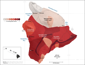
Imagine living near a volcano! To help people stay safe, scientists created special maps. These maps show how likely it is for lava to flow in different areas. These areas are called Lava Flow Hazard Zones. The United States Geological Survey (USGS) made these maps for the big island of Hawaiʻi in the United States.

The maps were first made in 1974 and updated in 1992. They show how dangerous lava flows might be. This is based on how often volcanoes on Hawaiʻi have erupted in the past. Zone 1 is the most dangerous, and Zone 9 is the safest.
Contents
Understanding Lava Flow Hazard Zones
Scientists create lava flow hazard zones by looking at a few things. They check where volcanoes have erupted before. They also see how much land has been covered by lava in the past. The shape of the land, called topography, also helps. It shows where lava might flow.
Zone 1: Highest Danger
- This zone includes the tops and rift zones of Kilauea and Mauna Loa volcanoes.
- These areas have had many eruptions in recent history.
- This means lava flows are very likely here.
Zone 2: High Danger
- These areas are next to Zone 1 and downhill from it.
- About 15% to 25% of Zone 2 has been covered by lava since the year 1800.
- Between 25% and 75% of this zone has been covered in the last 750 years.
- The danger slowly decreases as you move away from Zone 1.
Zone 3: Moderate Danger
- Zone 3 is less dangerous than Zone 2. This is because it is farther from active volcano vents.
- The land's shape also offers some protection.
- Only 1% to 5% of Zone 3 has been covered by lava since 1800.
- Between 15% and 75% of this zone has been covered in the last 750 years.
Zone 4: Hualalai Volcano Danger
- This zone covers all of the Hualalai volcano.
- Hualalai erupts less often than Kilauea or Mauna Loa.
- About 5% of this zone has been covered by lava since 1800.
- Less than 15% has been covered in the last 750 years.
Zone 5: Kilauea Protected Area
- This area is on the Kilauea volcano.
- It is currently protected by the shape of the land.
Zone 6: Mauna Loa Protected Areas
- This zone includes two areas on the Mauna Loa volcano.
- Both of these areas are protected by the land's shape.
Zone 7: Younger Mauna Kea Danger
- This zone is the younger part of the Mauna Kea volcano.
- About 20% of this area was covered by lava in the last 10,000 years.
Zone 8: Older Mauna Kea Danger
- This zone is the rest of the Mauna Kea volcano.
- Only a small part, a few percent, has been covered by lava in the last 10,000 years.
Zone 9: Safest Zone
- This zone covers the Kohala Volcano.
- Kohala last erupted more than 60,000 years ago. This makes it the safest zone.
The USGS Hawaiian Volcano Observatory has a list of frequently asked questions (FAQ). This helps people understand the map and how to use it.
 | Delilah Pierce |
 | Gordon Parks |
 | Augusta Savage |
 | Charles Ethan Porter |

