Lawnton, Pennsylvania facts for kids
Quick facts for kids
Lawnton, Pennsylvania
|
|
|---|---|

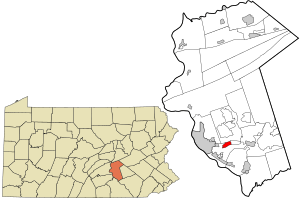
Location in Dauphin County and state of Pennsylvania.
|
|
| Country | United States |
| State | Pennsylvania |
| County | Dauphin |
| Township | Swatara |
| Area | |
| • Total | 1.46 sq mi (3.78 km2) |
| • Land | 1.46 sq mi (3.78 km2) |
| • Water | 0.00 sq mi (0.00 km2) |
| Elevation | 390 ft (120 m) |
| Population
(2020)
|
|
| • Total | 4,967 |
| • Density | 3,406.72/sq mi (1,315.66/km2) |
| Time zone | UTC-5 (Eastern (EST)) |
| • Summer (DST) | UTC-4 (EDT) |
| ZIP code |
17111
|
| Area code(s) | 717 |
| FIPS code | 42-41944 |
| GNIS feature ID | 1179050 |
Lawnton is a small community in Pennsylvania, United States. It is known as a census-designated place (CDP). This means it's a special area defined by the government for counting people. Lawnton is located in Swatara Township, which is part of Dauphin County.
In 2010, about 3,813 people lived in Lawnton. By 2020, the population grew to 4,967 people. Lawnton is also part of the larger Harrisburg–Carlisle area, which is a big group of cities and towns.
Contents
Where is Lawnton Located?
Lawnton is found in the southern part of Dauphin County. Its exact location is about 40 degrees North and 76 degrees West. It sits in the northern part of Swatara Township. To the east, Lawnton is next to the community of Rutherford.
A major highway, Interstate 83, runs along the western side of Lawnton. The state capital, Harrisburg, is only about 5 miles (8 kilometers) to the west.
Land Area of Lawnton
The United States Census Bureau says that Lawnton covers a total area of about 3.0 square kilometers (which is about 1.16 square miles). All of this area is land; there are no large bodies of water like lakes or rivers within Lawnton itself.
Who Lives in Lawnton?
| Historical population | |||
|---|---|---|---|
| Census | Pop. | %± | |
| 2020 | 4,967 | — | |
| U.S. Decennial Census | |||
In the year 2000, there were 3,787 people living in Lawnton. These people lived in 1,581 different homes. About 1,054 of these homes were families. The population density was about 3,342 people per square mile (1,290 people per square kilometer). This means a lot of people live close together in Lawnton.
People and Their Backgrounds
The people in Lawnton come from different backgrounds. In 2000, about 80% of the people were White. About 14.4% were African American. There were also smaller groups of Asian people (1.77%) and Native American people (0.08%). About 1.35% of people were from other backgrounds, and 2.27% were from two or more backgrounds.
About 3.8% of the population in 2000 identified as Hispanic or Latino.
Households and Families
Out of the 1,581 homes in Lawnton in 2000, about 33% had children under 18 living there. Nearly half of the homes (48.6%) were married couples living together. About 14.1% of homes had a female head of household without a husband.
The average home had about 2.38 people, and the average family had about 2.92 people.
Age Groups in Lawnton
The population of Lawnton in 2000 was spread out across different age groups:
- About 25% of the people were under 18 years old.
- About 8.1% were between 18 and 24 years old.
- The largest group, about 33.2%, was between 25 and 44 years old.
- About 20.8% were between 45 and 64 years old.
- About 12.9% of the people were 65 years old or older.
The median age in Lawnton was 37 years old. This means half the people were younger than 37 and half were older. For every 100 females, there were about 88 males.
See also
 In Spanish: Lawnton para niños
 | Claudette Colvin |
 | Myrlie Evers-Williams |
 | Alberta Odell Jones |

