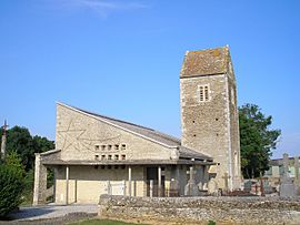
Le Bû-sur-Rouvres facts for kids
Quick facts for kids
Le Bû-sur-Rouvres
|
|
|---|---|
 |
|
| Country | France |
| Region | Normandy |
| Department | Calvados |
| Arrondissement | Caen |
| Canton | Bretteville-sur-Laize |
| Area
1
|
2.83 km2 (1.09 sq mi) |
| Population
(1999)
|
81 |
| • Density | 28.62/km2 (74.1/sq mi) |
| Time zone | UTC+01:00 (CET) |
| • Summer (DST) | UTC+02:00 (CEST) |
| INSEE/Postal code |
14116 /14190
|
| Elevation | 71–94 m (233–308 ft) (avg. 80 m or 260 ft) |
| 1 French Land Register data, which excludes lakes, ponds, glaciers > 1 km2 (0.386 sq mi or 247 acres) and river estuaries. | |
Le Bû-sur-Rouvres is a small commune in France. A commune is like a small town or village. It is located in the northwest part of the country.
Contents
Where is Le Bû-sur-Rouvres?
This commune is found in the region called Basse-Normandie. It is also part of the department known as Calvados. Both Basse-Normandie and Calvados are in the beautiful country of France.
Location Details
Le Bû-sur-Rouvres is near the city of Caen. It is also part of the canton of Bretteville-sur-Laize. A canton is a smaller area used for elections.
Who Lives in Le Bû-sur-Rouvres?
In 1999, the commune had a population of 81 people. This means it is a very small place. The people who live there are called its residents.
Local Government
The mayor of Le Bû-sur-Rouvres is Jacques François. He served from 2008 to 2014. A mayor is like the leader of the town. They help make decisions for the community.
How Big is Le Bû-sur-Rouvres?
The area of the commune is 2.83 square kilometers. This is a very small area. Its elevation, or height above sea level, is about 80 meters. The lowest point is 71 meters, and the highest is 94 meters.
See also
 In Spanish: Le Bû-sur-Rouvres para niños


