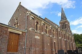
Le Mesnil-Simon, Calvados facts for kids
Quick facts for kids
Le Mesnil-Simon
|
|
|---|---|
 |
|
| Country | France |
| Region | Normandy |
| Department | Calvados |
| Arrondissement | Lisieux |
| Canton | Lisieux-3 |
| Intercommunality | Lisieux Pays d'Auge |
| Area
1
|
9.59 km2 (3.70 sq mi) |
| Population
(1999)
|
155 |
| • Density | 16.16/km2 (41.86/sq mi) |
| Time zone | UTC+01:00 (CET) |
| • Summer (DST) | UTC+02:00 (CEST) |
| INSEE/Postal code |
14425 /14140
|
| Elevation | 27–173 m (89–568 ft) (avg. 80 m or 260 ft) |
| 1 French Land Register data, which excludes lakes, ponds, glaciers > 1 km2 (0.386 sq mi or 247 acres) and river estuaries. | |
Le Mesnil-Simon is a small commune in France. A commune is like a small town or village. It is located in the Calvados department. This department is part of the Normandy region in the northwest of France.
Contents
Discover Le Mesnil-Simon
Le Mesnil-Simon is a quiet place in the French countryside. It is known for being a small community. The village is part of the Calvados department. This area is famous for its beautiful landscapes and history.
Where is Le Mesnil-Simon Located?
Le Mesnil-Simon is found in the northwest part of France. It is in the Normandy region. The closest big town is Lisieux. The village is surrounded by green fields and gentle hills.
How Big is Le Mesnil-Simon?
Le Mesnil-Simon covers an area of about 9.59 square kilometers. That's about 3.7 square miles. In 1999, only about 155 people lived there. This makes it a very small and peaceful place.
Government and Life in Le Mesnil-Simon
Like all communes in France, Le Mesnil-Simon has its own local government. This government helps manage the village.
Who is the Mayor?
The mayor of Le Mesnil-Simon is a person named Bruno Gondouin. The mayor is like the leader of the town. They help make decisions for the community. Bruno Gondouin was mayor from 2001 to 2008.
How is the Village Managed?
Le Mesnil-Simon is part of a larger group of communes called Lisieux Pays d'Auge. This group works together on things like services for the people. This helps small villages get more resources.
Geography and Nature
The land in Le Mesnil-Simon is mostly rural. It has different elevations.
What is the Elevation?
The lowest point in the commune is 27 meters (about 89 feet) above sea level. The highest point is 173 meters (about 568 feet). The average elevation is around 80 meters (about 262 feet). This means the area has some gentle slopes and hills.
See also
 In Spanish: Le Mesnil-Simon (Calvados) para niños


