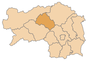
Leoben (district) facts for kids
Quick facts for kids
Leoben
Bezirk Leoben
|
|
|---|---|
 |
|
| Country | Austria |
| State | Styria |
| Number of municipalities | 17 |
| Area | |
| • Total | 1,099.7 km2 (424.6 sq mi) |
| Population
(2014)
|
|
| • Total | 61,771 |
| • Density | 56.1708/km2 (145.482/sq mi) |
| Time zone | UTC+01:00 (CET) |
| • Summer (DST) | UTC+02:00 (CEST) |
| NUTS code | AT223 |
The Leoben District is a special area in Styria, a state in Austria. Think of it like a county or a region. It covers about 1,052 square kilometers. That's a pretty big area!
As of January 1, 2019, around 60,060 people lived here. The main town and administrative center of the district is Leoben. This is where important offices and services for the district are located.
Towns and Villages in Leoben
A district is made up of many smaller areas called municipalities. A municipality can be a big town, a smaller market town, or a group of villages. These places work together to manage local services.
The Leoben District has 17 municipalities. Here are some of the main ones:
Major Towns
These are the biggest and most important places in the district.
- Eisenerz
- Leoben
- Trofaiach
Market Towns
Market towns are usually smaller than cities but bigger than villages. They often have a special history or importance for trade.
- Kalwang
- Kammern im Liesingtal
- Kraubath an der Mur
- Mautern in Steiermark
- Niklasdorf
- Sankt Michael in Obersteiermark
- Sankt Peter-Freienstein
- Vordernberg
Other Municipalities
These are other important villages and communities in the district.
- Hieflau
- Proleb
- Radmer
- Sankt Stefan ob Leoben
- Traboch
- Wald am Schoberpaß
See also
 In Spanish: Distrito de Leoben para niños
 | Kyle Baker |
 | Joseph Yoakum |
 | Laura Wheeler Waring |
 | Henry Ossawa Tanner |

