Lichtenfels (district) facts for kids
Quick facts for kids
Lichtenfels
|
||
|---|---|---|
|
||
| Country | ||
| State | Bavaria | |
| Adm. region | Upper Franconia | |
| Region | Oberfranken-West | |
| Capital | Lichtenfels | |
| Area | ||
| • Total | 552 km2 (213 sq mi) | |
| Population
(2000)
|
||
| • Total | 70,800 | |
| • Density | 128.26/km2 (332.2/sq mi) | |
| Time zone | UTC+1 (CET) | |
| • Summer (DST) | UTC+2 (CEST) | |
| Vehicle registration | LIF | |
| Website | landkreis-lichtenfels.de | |
Lichtenfels is a special area in Bavaria, Germany, called a Landkreis or district. Think of it like a county in other countries. It's a place where many towns and villages work together.
Discover the Towns and Villages of Lichtenfels
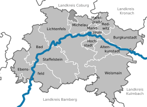
The Lichtenfels district is made up of several towns and smaller communities called municipalities. Each of these places has its own unique history and things to explore.
Here are the main towns you'll find in the Lichtenfels district:
- Bad Staffelstein
- Burgkunstadt
- Lichtenfels (This is also the main town, like the capital of the district!)
- Weismain
And here are the municipalities, which are often smaller villages or groups of villages:
- Altenkunstadt
- Ebensfeld
- Hochstadt am Main
- Marktgraitz
- Marktzeuln
- Michelau in Oberfranken
- Redwitz an der Rodach
See also
 In Spanish: Distrito de Lichtenfels para niños

All content from Kiddle encyclopedia articles (including the article images and facts) can be freely used under Attribution-ShareAlike license, unless stated otherwise. Cite this article:
Lichtenfels (district) Facts for Kids. Kiddle Encyclopedia.


