
Lindsay Creek facts for kids
Quick facts for kids Lindsay Creek |
|
|---|---|

The Botanic Garden section of Lindsay Creek
|
|


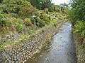
Mouth of Lindsay Creek
|
|
| Country | New Zealand |
| Physical characteristics | |
| Main source | Mount Cargill 45°49′08″S 170°32′46″E / 45.8188°S 170.5461°E |
| River mouth | Water of Leith 45°51′29″S 170°31′08″E / 45.85798°S 170.51879°E |
| Basin features | |
| Progression | Lindsay Creek → Water of Leith → Otago Harbour → Pacific Ocean |
The Lindsay Creek is a small river that flows through the northern parts of Dunedin, New Zealand. It's a branch of the Water of Leith. The local Māori name for the creek is Puke-haukea. This name might mean "to flow away from the hill."
Contents
Discover Lindsay Creek
Lindsay Creek is an important waterway in Dunedin. It helps drain water from the hills and flows through several well-known areas. It eventually joins a larger river system.
Where Does the Creek Flow?
The creek starts on the southern side of Mount Cargill. This mountain is also known as Kapukataumahaka. The creek begins about one kilometre from the mountain's top.
From there, Lindsay Creek flows south. It passes through a popular park called Bethunes Gully. After this, it reaches the suburban area of Normanby. The creek then continues flowing through North East Valley. It goes past Chingford Park and the Quarry Gardens.
Finally, it reaches a flat area near the coast called The Gardens Corner. Here, it flows into the Dunedin Botanic Gardens. This is where Lindsay Creek meets the Water of Leith. The Water of Leith is also known as Ōwheo.
Protecting Our Creek from Floods
Lindsay Creek has flooded many times in the past. These floods have caused problems for homes and businesses. For example, big floods happened in 1929 and 1955. The 1929 flood was part of a larger event called the Leith Flood of 1929. It caused water to cover many properties in North East Valley.
To stop future floods, people have done a lot of work. They are making the creek wider in different places. This helps more water flow through safely. After the 1929 flood, the creek's path was changed and walls were built. More work was done in 1965 and during the 1970s. These projects help protect the community from flooding.
Images for kids
-
The Botanic Garden section of Lindsay Creek
