
Lines of Stollhofen facts for kids
Imagine a giant wall built to protect a country! The Lines of Stollhofen (also called the Bühl-Stollhofen Line in German) were like that. They were a long line of defenses built in Germany. These defenses were made of earth and other materials. They were created for the Reichsarmee, which was the army of the Holy Roman Empire.
The lines were built at the start of the War of the Spanish Succession. This big war lasted from 1701 to 1714. The Stollhofen Lines stretched for about 15 kilometers (9 miles). They went from Stollhofen, a town near the Rhine River, all the way to thick forests east of Bühl.
Margrave Louis William of Baden-Baden ordered these lines to be built. His goal was to protect the northern part of Baden. He wanted to keep it safe from a new French fortress. This fortress, called Fort Louis, was on the Rhine River.
Contents
Where Were the Stollhofen Lines Located?
This defensive line was about 15 kilometers (9 miles) long. It was only partly fortified, meaning not all parts were equally strong. The line started in the east near Obertal. Today, Obertal is part of Bühlertal.
From Obertal, the line went west over hills to Bühl. Then, it turned northwest into the Rhine valley. It passed through villages like Vimbuch (now part of Bühl) and Leiberstung (now part of Sinzheim). Finally, it reached Stollhofen and ended at the River Rhine.
The lines included different types of defenses. There were long, straight earthworks called schanzen. There were also star-shaped schanzen and other small forts. Some villages were also made stronger. The builders even used water from the Rhine Plain. They built weirs (small dams) to flood the areas in front of the lines. This made it harder for enemies to attack.
The lines also helped control important trade routes. They included the villages of Bühl and Stollhofen. This allowed them to watch over the old road from Basle to Frankfurt (today's B3 highway). They also controlled the old Roman road from Strasbourg to Frankfurt (today's B36 highway). Until 1707, these lines stopped French troops from moving easily. They blocked the simplest path to Bavaria through Pforzheim.
-
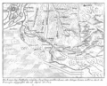
A 1720 map showing the entire Stollhofen Line.
-
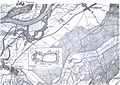
The northern part of the Stollhofen Line.
-

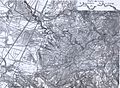
The central part of the Stollhofen Line.
-
The southern part of the Stollhofen Line.


Key Events in the History of the Lines
In February 1703, a French general named Marshal Villars crossed the Rhine River. He found that the mountain passes through the Black Forest were still blocked by snow. So, he first captured Kehl Fortress on March 12. This fortress became his base east of the Rhine.
Villars then joined forces with Marshal Tallard. On April 19, 1703, they began an attack on the Bühl-Stollhofen Line. Villars bombed the line south of Kappelwindeck. He also tried to go around the line to the east. He sent 25 groups of soldiers under a commander named Blainville.
Both attacks, on April 19 and April 24, failed. The French could not capture the forts at Obertal. On April 25, Villars had to pull his troops back.
However, in the summer of 1703, Margrave Louis William could not stop Villars. Villars marched through the Kinzig valley and into Bavaria. There, Villars won an important battle called the First Battle of Höchstädt. In 1704, Tallard also passed through the Black Forest easily. He went along the Dreisam Valley.
Margrave Louis William died on January 9, 1707. Several months later, in May, Villars captured the Bühl-Stollhofen Line without a fight. He then ordered the lines to be destroyed.
After the Stollhofen Line was lost, new defenses were started. These were called the Ettlingen Line. They were built under the command of George Louis of Brunswick-Lüneburg. He was the leader of the Rhine Army. The Ettlingen Line was made stronger during the War of the Polish Succession (1733–1738). The French destroyed it in 1734, but it was rebuilt in 1735.
What Remains of the Lines Today?
Over the years, the Rhine River was changed by Tulla in the 1800s. Also, new roads and towns were built in the last century. Because of this, only small parts of the Stollhofen Line are still visible today. You can mostly see them in the wooded areas east of Bühl.
The Bühl Municipal Museum has an interesting item. It has a map of the Bühl-Stollhofen Line from 1703. This map was drawn by Major Elster.
See Also
- Baroque fortifications in the Black Forest
- Eppingen lines
- Johan Wijnand van Goor defended the lines in 1703.
- Battle of Blenheim (August 1704) – the lines helped block the enemy before this battle.
- Prince Eugene of Savoy commanded the forces on the line before the Battle of Blenheim.
- Marshal Villars attacked the lines in May 1707.
