
List of Indiana state historical markers in Johnson County facts for kids

Welcome to Johnson County, Indiana! This area is home to special markers that tell us about important people and events from the past. These "historical markers" are like outdoor history books, placed by the Indiana Historical Bureau. They help us remember and learn about the interesting history of this part of Indiana, United States.
There are five of these cool historical markers in Johnson County. Each one shares a unique story about someone famous or a big moment in history. Let's explore them and discover what makes Johnson County's past so special!
Famous People and Places in Johnson County History
Johnson County has been home to many important people and events. These historical markers celebrate their stories.
Paul Vories McNutt: A Leader from Franklin
The first marker celebrates the Birthplace of Paul Vories McNutt. He was born in Franklin in 1891. Paul McNutt grew up to be a very important person in Indiana and the United States.
- What he did: Paul McNutt became the Governor of Indiana. He also worked for the U.S. government in different roles, helping lead the country during tough times.
- Where to find it: This marker was placed in 1992 at 200 Walnut Street in Franklin. It reminds us of his early life in the town.
- Why he's important: He made a big difference in education and government.
Roger D. Branigin: Another Governor from Franklin
Another marker in Franklin honors the Birthplace of Roger D. Branigin. He was born in Franklin in 1902, just a few years after Paul McNutt. It's amazing that two governors came from the same small town!
- What he did: Roger Branigin also became the Governor of Indiana. He was known for his work in civil rights, which means making sure everyone has fair and equal treatment. He also cared a lot about education.
- Where to find it: This marker was put up in 2000 at 250 Yandes Street in Franklin.
- Why he's important: He helped improve civil rights and education for people in Indiana.
William Merritt Chase: A Talented Artist
Near Nineveh, you can find a marker for William Merritt Chase. He was a very famous American painter. He was born in 1849 and became known for his beautiful portraits and landscapes.
- What he did: William Merritt Chase taught art and created many amazing paintings. His work is displayed in art museums all over the world.
- Where to find it: This marker was placed in 2010 at 7784 S. Georgetown Road, near Nineveh.
- Why he's important: He was a leading figure in American art and inspired many other artists.
The Franklin Wonder Five: Basketball Legends
If you love basketball, you'll be interested in the marker for the Franklin Wonder Five. This was a legendary high school basketball team from Franklin in the 1920s. They were incredibly good and won many championships!
- What they did: This team won three state championships in a row from 1920 to 1922. They were known for their teamwork and skill.
- Where to find it: This marker was added in 2020. You can find it at 642-674 Grizzly Drive, on the east side of the Franklin College Fitness Center in Franklin.
- Why they're important: They showed how exciting high school sports could be and brought a lot of pride to Franklin.
Ray Crowe: A Coach Who Changed Lives
The newest marker in Johnson County honors Ray Crowe, who lived from 1915 to 2003. He was a truly inspiring basketball coach and a leader in his community.
- What he did: Ray Crowe coached the Crispus Attucks High School basketball team in Indianapolis. He led them to become the first all-Black team in the nation to win a state championship in 1955. This was a huge moment in sports history and for civil rights. He also worked in education and politics.
- Where to find it: This marker was placed in 2023 at 50 Center Street in Whiteland.
- Why he's important: He broke barriers in sports and inspired many young people.
Images for kids
-
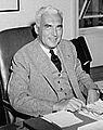
Paul V. McNutt, a former Governor of Indiana.
-
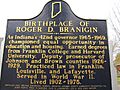
The historical marker for Roger D. Branigin's birthplace.
-
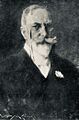
A portrait of the artist William Merritt Chase.
-
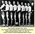
The famous Franklin Wonder Five basketball team in 1920.


