
List of New York State Historic Markers in Oneida County, New York facts for kids
New York State Historic Markers in Oneida County
Oneida County, New York, is full of interesting history! All around the county, you can find special signs called historic markers. These markers are like outdoor history books, telling us about important people, places, and events that happened right where you're standing. They help us remember the past and learn about how our communities grew. This article will take you on a journey through some of the most exciting stories marked by these signs in Oneida County.
Contents
- Historic Stories from Oneida County
- Augusta and Oriskany Falls
- Boonville and Canals
- Bridgewater and Deerfield
- Floyd and Forestport
- Kirkland and Hamilton College
- Marshall, New Hartford, and Paris
- Remsen and Baron Steuben
- Rome and its Forts
- Sangerfield, Steuben, and Trenton
- Utica, Vernon, and Verona
- Western and Westmoreland
- Whitestown and its Beginnings
- Images for kids
- See also
Historic Stories from Oneida County
Augusta and Oriskany Falls
The towns of Augusta and Oriskany Falls have a rich past, especially when it comes to early settlements and important buildings.
Early Settlements and Buildings
- Augusta, New York: This town was officially formed on March 15, 1798. It was created from a larger area known as the Town of Whitestown.
- "STONE CHURCH": In Oriskany Falls, you can find a marker for the "Stone Church." It was built in 1834 by the Congregational Society.
- Augusta Academy: Also in Oriskany Falls, the Augusta Academy was founded in 1834. It had a very unique semicircular stone building that was used until 1878. People thought its design was quite unusual!
- Augusta Church: The Augusta Church was organized in 1797 by the Congregational Society, making it one of the very early churches in the area.
- Cassety Hollow: This area, now known as Oriskany Falls, was settled in 1794 by Thomas Cassety. He built a grist mill here, which was important for grinding grain.
- The Gunn House: About half a mile north of Oriskany Falls, a marker points to the site of the Gunn House. Built in 1793, it was the very first house built by a white settler in the Town of Augusta.
- First Log School: Near Augusta, the first log school in the area was built in 1797. Back then, Augusta was called Bartlett's Corner. This log building was also used as a church and a meeting house.
Important People and Canals
- Amos Parker: A marker south of Augusta tells the story of Amos Parker (1762–1842). He was known as the tallest man in the American Army and even saved General Lafayette's life during the American Revolutionary War. He was also present when the British General Cornwallis surrendered.
- Dr. A. Burgoyne: In Knoxboro, you can find the burial site of Dr. A. Burgoyne (1737–1824). He was a physician at Saratoga in 1777, serving under General Burgoyne.
- Chenango Canal: The Chenango Canal was a big deal for transportation! It was authorized in 1833 to connect Utica to Binghamton and was finished in 1836. It had an amazing 72 locks in just 30 miles, but it was stopped in 1876.
- Utica Clinton Binghamton R.R.: This railroad company was formed in 1862. The line from Utica was completed to Oriskany Falls by 1858 and extended south in 1871.
Knoxboro History
- INDIAN TRAIL:

In Knoxboro, a marker points to an old Indian Trail. Around 1700, this trail was used by the Oneida, Tuscarora, Brotherton, and Stockbridge Native American tribes for trade and travel. It became a public highway soon after 1800.
- Knox House: The Knox House was built in 1820 by General J. J. Knox, an early settler who arrived in 1791. The village of Knoxboro was named in his honor.
- Lock Company: In Knoxboro, a marker shows the site of a Lock Company, which was started in 1862 by J.C. Knox. This company made high-quality locks for many years.
- Union Church: The Union Church in Knoxboro was built in 1849 by Methodists and Presbyterians. The lumber for it was even brought from an older church built around 1800. In 1873, it was turned into a school.
Boonville and Canals
Boonville is another historic town with connections to important waterways and early settlers.
- Boonville, New York: This town was settled in 1795 and named after Gerrit Boon, an agent for the Holland Land Company. The town was formed in 1805, and the village was officially incorporated in 1855.
- Black River Canal: There are two markers for the Black River Canal near Boonville.
* One marker points to Lock 71, which was at the highest point of the canal, 710 feet above Rome. From here, water flowed north to the St. Lawrence River and south to the Mohawk River. * Another marker highlights the "Five Combines," a world record for the number of canal locks in one spot. The Black River Canal had 109 locks over 35 miles!
- FIRST PRESBYTERIAN CHURCH: The First Presbyterian Church society in Boonville was organized in 1805. The current church building was constructed between 1855 and 1856.
- OLD FRENCH ROAD: About a mile southeast of Boonville, you can find a marker for the Old French Road. This road was built by French colonists in 1790 as they traveled to settle Castorland. It was the first road leading to the "North Country" and followed an old Iroquois Native American war trail.
Bridgewater and Deerfield
- BIRTHPLACE OF Dr. Stephen Moulton Babcock: In Bridgewater, a marker celebrates the birthplace of Dr. Stephen Moulton Babcock (1843–1931). He was a famous scientist and inventor of the Babcock Milk Test, which helps check the fat content in milk. He was a great friend to agriculture.
- BRIDGEWATER: The town of Bridgewater became part of Oneida County on March 24, 1797, and was transferred from Chenango County on April 4, 1804.
- DEERFIELD: The town of Deerfield was formed on March 15, 1798, from the Town of Schuyler in Herkimer County.
- ARROW (to Baron Steuben's Tomb): Several markers, like one near Deerfield, point the way to the tomb of Baron Steuben in the State Memorial Park near Remsen.
Floyd and Forestport
- FLOYD: The town of Floyd was formed on March 4, 1796. It was named in honor of William Floyd (1734–1821), who was one of the signers of the United States Declaration of Independence.
- FORESTPORT: The town of Forestport was established in 1869, and the village in 1903. The first settlement here was in 1795. In 1777, during the Revolutionary War, St. Leger's Native American allies retreated through this area from Oriskany to Crown Point.
- ST. LEGER'S HILL: Five miles east of Forestport, a marker on St. Leger's Hill notes that in 1777, about 450 of St. Leger's Native American forces retreated this way from the Battle of Oriskany.
Kirkland and Hamilton College
Kirkland is home to the historic Hamilton College.
- ELIHU ROOT: On the Hamilton College Campus in Clinton, a marker shows the birthplace of Elihu Root (born February 15, 1845). He was a very important person, serving as Secretary of War, Secretary of State, and a United States Senator.
- FIRST GRIST MILL: Near Clinton, the first grist mill in the area was built in the winter of 1787. Before this, early settlers had to carry their grain all the way to Whitestown to be ground!
- HAMILTON COLLEGE: Hamilton College was first founded as the Hamilton-Oneida Academy in 1793 by Reverend Samuel Kirkland. It officially became Hamilton College on May 26, 1812.
- HAMILTON COLLEGE CHAPEL: The chapel on the Hamilton College Campus was built in 1827. It's known for its unusual and unique three-story design by Philip Hooker of Albany.
- WASHINGTON TRACT: South of Kirkland, a marker explains that these lands were part of a parcel given to Nathaniel Griffin by George Washington and Dewitt Clinton in 1790.
Marshall, New Hartford, and Paris
- HOME OF Brotherton Indians: Northwest of Waterville, a marker notes the home of the Brotherton Indians from 1783 to 1850. Samson Occom, a Native American Presbyterian preacher, lived among them from 1785 to 1792.
- 1ST RELIGIOUS Society of Whitestown: In New Hartford, a marker tells about the first religious society of the Town of Whitestown, organized in 1791. Their church was dedicated on November 29, 1797.
- A GRIST MILL: In New Hartford, a grist mill was built in 1790 by Jedediah Sanger, who was the first settler and founder of New Hartford.
- JEDEDIAH SANGER: Jedediah Sanger founded New Hartford in 1788 by buying 1000 acres of land and settling there with his family.
- BIRTHPLACE OF Dr. Asa Gray: In Sauquoit (Town of Paris), there are markers for the birthplace of Dr. Asa Gray (born November 18, 1810; died January 30, 1888). He was a world-famous botanist, someone who studies plants.
- METHODIST CHURCH: The first sermon in Northern New York was preached in 1788 by Elder Freeborn Garretson within Whitestown. The Sauquoit Methodist Society was formed in 1788, making it the first in the conference.
Remsen and Baron Steuben
Remsen is closely tied to the history of Baron Steuben, a hero of the American Revolution.
- REMSEN:

The town of Remsen was formed on March 15, 1798, from the Town of Norway in Herkimer County.
- Col. Marinus Willett: East of Forestport, a marker tells how Colonel Marinus Willett routed a British-Tory force on October 30, 1783, along West Canada Creek. Walter Butler, the Tory leader, was killed by an Oneida Native American during this event.
- Baron Steuben Memorial Park: Many markers point to the Baron Steuben Memorial Park, which is near Remsen. This park is dedicated to Friedrich Wilhelm Baron von Steuben.
* FRIEDRICH WILHELM Baron Von Steuben: Born September 17, 1730, in Magdeburg, Germany, Baron von Steuben died here on November 28, 1794. He was a Major General and Inspector General of the Army during the American Revolution. * FIRST GRAVE Of Baron Steuben: Near the memorial, a marker shows the spot where Baron Steuben was first buried. By his own wish, he was buried in an unmarked grave, wrapped in his military cloak. * THIS MONUMENT: The monument at the memorial covers Baron Steuben's remains. The cornerstone was laid on June 1, 1870, and the monument was completed in 1872. * SACRED GROVE: In 1804, these woods were named "Sacred Grove" because of their connection to Baron Steuben, the American patriot. * STEUBEN GRANT: Baron Steuben received a grant of 16,000 acres from the State of New York on June 27, 1786, for his service in the Revolution. He cleared sixty acres near here for his home site between 1788 and 1793. * STEUBEN STATE Memorial Park: This park was dedicated on September 12, 1931, by Franklin D. Roosevelt, who was then the Governor of New York. Fifty acres of the park were given in 1804 by Colonel Benjamin Walker, a friend and aide of Steuben, to the Second Baptist Church. * TOWN OF STEUBEN: The town of Steuben was formed on April 10, 1792, and named in honor of Baron Steuben. It originally covered a much larger area.
People and Farms in Steuben
- ROBERT EVERETT: West of Remsen, a marker points to the home site of Robert Everett (1791–1875), an anti-slavery reformer and minister.
- SAMUEL SIZER: Samuel Sizer was the first settler on the Steuben Grant in 1787 and managed Baron Steuben's farm. His burial place is in a meadow nearby.
- CAPT. SIMEON WOODRUFF: Half a mile west of Remsen, a marker for Captain Simeon Woodruff notes that he sailed around the world with Captain Cook. He leased his farm from Baron Steuben in 1791.
- EENEZER WEEKS: Ebenezer Weeks settled here in 1791 and built a bake oven. He also did coopering (making barrels) for Baron Steuben.
- FULLER FARM: The Fuller Farm was acquired in 1793 from Baron Steuben by Captain Simeon Fuller. His descendants have owned it ever since.
- SAW-MILL: Near a creek north of Fuller Road, a marker indicates the site of Baron Steuben's saw-mill, built in 1790. You can still see remains of the dam.
- STARR HILL: West of the Baron Steuben Memorial, Starr Hill was named for David Starr, a captain in the Continental Army and a friend of Baron Steuben, who settled here in 1791.
- WELSH IMMIGRANTS: Beginning in 1795, Welsh immigrants cleared and settled much of the Steuben Grant. They built their first church here in 1804.
Rome and its Forts
Rome is a city rich in military and canal history.
- 1755–1756 Forts: Several markers in Rome point to the sites of colonial forts and Revolutionary War battlefields.
* Fort Williams: This fort guarded the Upper Mohawk Landing and was burned by British General Webb in a panic. * DURING SIEGE OF Fort Stanwix: During the siege of Fort Stanwix in August 1777, the main British camp was between this point and the bluff to the south. * FORT CRAVEN: Fort Craven was destroyed in a British panic before it was even finished on August 31, 1756. * FORT NEWPORT: This was a small colonial post that guarded the Upper Wood Creek Landing Place.
- HERE PASSED Ancient Carry: Markers show where the "Ancient Carry" passed from the Mohawk River to Wood Creek. This was an important portage route.
- INLAND CANAL: The Inland Canal was started in 1792, and the Second Erie Canal was completed here in 1844.
- OLD BLACK RIVER CANAL: The Black River Canal was built from 1836 to 1855. It connected the Mohawk Valley with the Black River Country, opening up 90 miles of navigable waterway, and joined the Erie Canal here.
- ROME: The city of Rome was formed on March 4, 1796, from the Town of Steuben.
- U.S. Arsenal: A marker shows the site of the U.S. Arsenal, which was maintained during the War of 1812 and afterward.
- THE CENTRAL N.Y. School For The Deaf: This school was founded on January 27, 1875, by Alphonso Johnson, Thomas Gallaudet, and citizens of Rome.
- Historic Elm: An arrow points to a historic elm tree that was a sapling growing on the southwest bastion of Fort Stanwix in 1804.
- ORISKANY Battlefield: Near Rome, a marker invites the public to the Oriskany Battlefield, where a significant battle took place in 1777.
- Jesse Williams: North of Rome, a marker notes that Jesse Williams started the cheese factory system in 1851, which completely changed how dairy products were made.
Sangerfield, Steuben, and Trenton
- BIRTHPLACE OF George Eastman: In Waterville (Town of Sangerfield), a marker celebrates the birthplace of George Eastman (born July 12, 1854; died March 14, 1932). He was the inventor of the Kodak camera!
- PROPERTY LINE: North of Waterville, a marker shows the western boundary of civilization fixed by the Fort Stanwix Treaty on November 5, 1768. Sir William Johnson witnessed this important treaty.
- SANGERFIELD: The town of Sangerfield became part of Oneida County on March 15, 1795, and was transferred from Chenango County on April 4, 1804.
- CINCINNATI CREEK: Southeast of Trenton, Cincinnati Creek was named by Baron Steuben to remember the Society of the Cincinnati, which he helped create in 1783.
- TRENTON: The town of Trenton was formed on March 24, 1797, from the Town of Schuyler in Herkimer County.
Utica, Vernon, and Verona
- BAGG'S TAVERN: In Utica, Bagg's Tavern was originally a log house founded in 1794 by Moses Bagg. Famous guests like George Washington, General Lafayette, Henry Clay, and General Grant stayed here!
- MISSION CHURCH Of The Oneidas: In Vernon, a marker points to the Mission Church of the Oneidas, built by Reverend Eleazer Williams in 1818. It was moved in 1842 and has been the Vernon Town Hall since 1892.
- ONEIDA CASTLE: In Oneida Castle Village, a marker identifies this as the chief village of the Oneida Tribe of Native Americans, who were members of the Iroquois Confederacy.
- ROYAL Blockhouse: In Sylvan Beach (Town of Verona), a marker shows where a fort, the Royal Blockhouse, was built by the British in 1759.
- STARK'S LANDING: In Higginsville (Town of Verona), Javez Hough Stark, a pioneer, built the first Presbyterian Church in Seneca Falls in 1807. He came here in 1821 and built a house across the canal between 1823 and 1825.
Western and Westmoreland
- WESTERN: The town of Western became part of Oneida County on March 10, 1797, formed from the Town of Steuben.
- BIRTHPLACE OF Samuel Eels: In Westmoreland, a marker notes the birthplace of Samuel Eels (1810–1842). In 1832, he founded the Alpha Delta Phi Fraternity at Hamilton College.
Whitestown and its Beginnings
- 1ST PRESBYTERIAN Church Of Whitesboro: In Whitesboro, the First Presbyterian Church was organized on April 1, 1793, with Bethuel Dodd as its first pastor.
- ENGLISH HOME: In Yorkville, an English home built in 1792 was the birthplace of Henry Inman (1801–1846). He was a famous artist known for his portraits, landscapes, and miniature paintings.
- COLONEL GERRIT G. LANSING: In Oriskany, a marker shows where the home of Colonel Gerrit G. Lansing once stood. He was an officer in the Continental Army who bought the land where Oriskany was founded in 1902.
- Woolen Mill: Also in Oriskany, a marker points to the site of a Woolen Mill built in 1810. It is believed to be the first in America to make fabrics from raw materials!
- TOWN HALL: In Whitesboro, the Town Hall was built in 1807 and was an early county courthouse. It was given to Whitestown by Hon. Philo White in 1860.
- WHITESTOWN: The town of Whitestown was formed on March 7, 1788. It was named in honor of Judge Hugh White, who was one of the first settlers in May 1784.
Images for kids
-
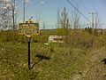
This marker shows where an old Indian trail used to be near Knoxboro.
-
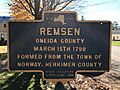
This marker welcomes visitors to Remsen, a town with a rich history.
See also
