
List of Pennsylvania state historical markers in Clearfield County facts for kids

Have you ever seen a special sign by the road or in a town that tells you about something important that happened there? These are called historical markers! They are like outdoor history books, showing us where cool events took place or where famous people lived.
In Clearfield County, Pennsylvania, there are 12 official historical markers. These signs were put up by the Pennsylvania Historical and Museum Commission (PHMC). They help us learn about the county's past, from old trails and important people to early industries. Let's explore some of these interesting spots!
Historical Markers in Clearfield County
Clearfield County is full of history, and these markers help us discover it. Each one tells a unique story about the area.
Canoe Place
This marker tells us about a spot that was important for Native Americans and early travelers. It was a place where people would switch from traveling by land to using canoes on the water, or vice versa. It was a key point for transportation a long time ago.
A. W. Tozer (1897-1963)
A. W. Tozer was a very important writer and pastor. He was known for his deep thoughts on religion and his many books. This marker honors his life and his contributions as a writer and religious leader.
Arnold N. Nawrocki (1925-2003)
Arnold N. Nawrocki was a clever inventor and businessman. He made important contributions in the world of business and industry. This marker celebrates his work and ideas.
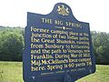
The Big Spring
The Big Spring is a natural spring that played a role in the history of the area. It was important for both Native Americans and early settlers. The marker also touches on military history, old paths, and even sports connected to the area.
Chinklacamoose
This marker points to an early settlement in Clearfield County. It tells us about the very first communities and how the government worked in the 1700s. It also reminds us of the Native American history in this region.
Clearfield County
This marker is about Clearfield County itself! It highlights the county's history, including its government and how it grew over time. It also mentions the importance of transportation in the county's development during the 1800s. You can find this marker near the County Historical Museum.
George Rosenkrans
George Rosenkrans was a talented person involved in music and theater. He was also a writer and had connections to religion. This marker celebrates his life and his performances.
Karthaus Furnace
The Karthaus Furnace marker tells the story of an old iron furnace. Furnaces like this were very important for making iron, which was used for many things. This marker shows us a piece of the county's industrial past, especially its history with coal and iron.
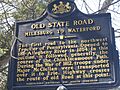
Old State Road (Milesburg to Waterford)
This marker is about a very old road that connected Milesburg to Waterford. Roads like this were vital for travel and trade in early Pennsylvania. It also has links to military history, as these paths were often used by soldiers.
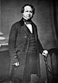
Philip P. Bliss
Philip P. Bliss was a famous musician, performer, and writer. He was known for his religious music. This marker celebrates his life and his impact on music and religion. He also had connections to agriculture and business in the area.
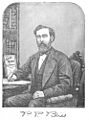
William Bigler (1814-1880)
William Bigler was a very important political figure. He served as the Governor of Pennsylvania and was involved in the Civil War. This marker honors his contributions to government and politics in the 1800s.
Zenas Leonard (1809-1857)
Zenas Leonard was an explorer. This marker tells us about his adventures and his role in exploring new lands. He helped map out parts of the American West.
Images for kids
-

Canoe Place marker
-
A. W. Tozer marker
-
Arnold N. Nawrocki marker
-
The Big Spring marker
-
Chinklacamoose marker
-
Clearfield County marker
-
George Rosenkrans marker
-
Karthaus Furnace marker
-
Old State Road marker
-
Philip P. Bliss marker
-
William Bigler marker
-
Zenas Leonard marker


