kids encyclopedia robot

List of Sites of Special Scientific Interest in Derbyshire facts for kids

Kids Encyclopedia Facts
ThorpeCloud
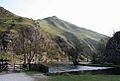
Thorpe Cloud and Dovedale, in the Dove Valley and Biggin Dale SSSI, Derbyshire

This is a list of the Sites of Special Scientific Interest (SSSIs) in Derbyshire, England, United Kingdom. In England the body responsible for designating SSSIs is Natural England, which chooses a site because of its fauna, flora, geological or physiographical features. Natural England uses the borders of Derbyshire to mark one of its Areas of Search. As of 2012, there are 99 sites designated in this Area of Search. There are 28 sites with a purely geological interest, and 54 listed for biological interest. A further 17 sites are designated for both reasons.

Natural England took over the role of designating and managing SSSIs from English Nature in October 2006 when it was formed from the amalgamation of English Nature, parts of the Countryside Agency and the Rural Development Service. Natural England, like its predecessor, uses the 1974–1996 county system and as such the same approach is followed here. The data in the table is taken from Natural England in the form of citation sheets for each SSSI, and the County Background Datasheet for Derbyshire.

For other counties, see List of SSSIs by Area of Search.

Sites

Site name Reason for designation Area Coordinates & Grid ref Year in which notified Other designations Map & Citation
Biological interest Geological interest Hectares Acres
Abney & Bretton Cloughs YesY 147.8 365.3 53°18′29″N 1°41′20″W / 53.308°N 1.689°W / 53.308; -1.689 (Abney & Bretton Cloughs)
    SK208790
1972 NP Map
Ambergate and Ridgeway Quarries YesY 1.0 2.5 53°03′29″N 1°28′01″W / 53.058°N 1.467°W / 53.058; -1.467 (Ambergate and Ridgeway Quarries)
    SK358513
1963 GCR Map
Attenborough Gravel Pits YesY 226.6 559.9 52°53′56″N 1°13′41″W / 52.899°N 1.228°W / 52.899; -1.228 (Attenborough Gravel Pits)
    SK520338
1982 WT Map
Bage Mine YesY 0.1 0.3 53°05′28″N 1°34′01″W / 53.091°N 1.567°W / 53.091; -1.567 (Bage Mine)
    SK291549
1985 GCR Map
Baileycroft Quarry YesY 0.9 2.1 53°05′06″N 1°34′26″W / 53.085°N 1.574°W / 53.085; -1.574 (Baileycroft Quarry)
    SK286543
1985 GCR Map
Ballidon Dale YesY 50.8 125.6 53°06′04″N 1°41′49″W / 53.101°N 1.697°W / 53.101; -1.697 (Ballidon Dale)
    SK204560
1996 NP, SAC Map
Bee's Nest and Green Clay Pits YesY YesY 15.0 37.0 53°05′13″N 1°38′35″W / 53.087°N 1.643°W / 53.087; -1.643 (Bee's Nest and Green Clay Pits)
    SK240545
1990 GCR, SAC Map
Benty Grange YesY 21.1 52.0 53°10′26″N 1°46′55″W / 53.174°N 1.782°W / 53.174; -1.782 (Benty Grange)
    SK146641
2012 Map
Bonsall Leys YesY 15.4 38.2 53°06′47″N 1°36′22″W / 53.113°N 1.606°W / 53.113; -1.606 (Bonsall Leys)
    SK265574
1993 Map
Boulton Moor YesY 3.9 9.7 52°52′52″N 1°26′13″W / 52.881°N 1.437°W / 52.881; -1.437 (Boulton Moor)
    SK380316
1992 GCR Map
Bradbourne Mill Meadows YesY 6.9 17.0 53°04′05″N 1°42′14″W / 53.068°N 1.704°W / 53.068; -1.704 (Bradbourne Mill Meadows)
    SK199524
2011 Map
Bradwell Dale and Bagshaw Cavern YesY 95.2 235.2 53°19′16″N 1°44′53″W / 53.321°N 1.748°W / 53.321; -1.748 (Bradwell Dale and Bagshaw Cavern)
    SK169805
1964 GCR Map
Bradwell Meadows YesY 0.9 2.3 53°19′19″N 1°44′10″W / 53.322°N 1.736°W / 53.322; -1.736 (Bradwell Meadows)
    SK177806
1990 Map
Breadsall Railway Cutting YesY YesY 4.9 12.0 52°57′11″N 1°25′08″W / 52.953°N 1.419°W / 52.953; -1.419 (Breadsall Railway Cutting)
    SK391397
1986 GCR, LNR, WT Map
Calke Park YesY 71.1 175.8 52°48′04″N 1°27′58″W / 52.801°N 1.466°W / 52.801; -1.466 (Calke Park)
    SK361227
1992 Map
Calton Hill YesY 5.2 12.7 53°14′20″N 1°49′41″W / 53.239°N 1.828°W / 53.239; -1.828 (Calton Hill)
    SK116713
1951 GCR Map
Carver's Rocks YesY 16.7 41.2 52°48′00″N 1°30′43″W / 52.8°N 1.512°W / 52.8; -1.512 (Carver's Rocks)
    SK330226
1963 Map
Castleton YesY YesY 837.3 2,069.1 53°20′13″N 1°48′11″W / 53.337°N 1.803°W / 53.337; -1.803 (Castleton)
    SK132823
1954 GCR, NP, NT Map
Cawdor Quarry YesY 4.7 11.7 53°08′28″N 1°34′30″W / 53.141°N 1.575°W / 53.141; -1.575 (Cawdor Quarry)
    SK285605
1963 GCR Map
Chatsworth Old Park YesY 72.5 179.2 53°13′01″N 1°36′22″W / 53.217°N 1.606°W / 53.217; -1.606 (Chatsworth Old Park)
    SK264689
1998 NP Map
Chrome and Parkhouse Hills YesY YesY 30.7 75.9 53°12′07″N 1°53′42″W / 53.202°N 1.895°W / 53.202; -1.895 (Chrome and Parkhouse Hills)
    SK071672
1951 NP, RIGS Map
Clough Woods YesY 109.4 270.4 53°09′04″N 1°37′19″W / 53.151°N 1.622°W / 53.151; -1.622 (Clough Woods)
    SK254616
1964 SM, NP Map
Colehill Quarries YesY 11.3 27.9 53°05′31″N 1°34′26″W / 53.092°N 1.574°W / 53.092; -1.574 (Colehill Quarries)
    SK286551
1985 GCR Map
Combs Reservoir YesY 32.0 79.1 53°18′43″N 1°56′38″W / 53.312°N 1.944°W / 53.312; -1.944 (Combs Reservoir)
    SK038794
1986 Map
Coombs Dale YesY 86.0 212.4 53°15′50″N 1°40′12″W / 53.264°N 1.67°W / 53.264; -1.67 (Coombs Dale)
    SK221742
1954 NP, NCR, SAC Map
Crabtree Wood YesY 3.5 8.7 53°18′04″N 1°15′58″W / 53.301°N 1.266°W / 53.301; -1.266 (Crabtree Wood)
    SK490785
1981 Map
Cressbrook Dale YesY YesY 120.4 297.6 53°15′47″N 1°44′17″W / 53.263°N 1.738°W / 53.263; -1.738 (Cressbrook Dale)
    SK176740
1954 GCR, NNR, NP, NCR, SAC Map
Creswell Crags YesY 19.5 48.1 53°15′43″N 1°12′04″W / 53.262°N 1.201°W / 53.262; -1.201 (Creswell Crags)
    SK534742
1981 SM, GCR Map
Cromford Canal YesY 10.2 25.1 53°05′49″N 1°31′05″W / 53.097°N 1.518°W / 53.097; -1.518 (Cromford Canal)
    SK324556
1981 LNR, WT Map
Dale Quarry YesY 2.0 4.9 53°04′59″N 1°34′48″W / 53.083°N 1.58°W / 53.083; -1.58 (Dale Quarry)
    SK282541
1998 GCR Map
Dark Peak YesY YesY 31,852.9 78,708.4 53°26′N 1°41′W / 53.44°N 1.69°W / 53.44; -1.69 (Dark Peak)
    SK207937
1951 SPA, GCR, NP, NT, NCR, SAC Map
Dimminsdale YesY 37.0 91.4 52°47′28″N 1°26′38″W / 52.791°N 1.444°W / 52.791; -1.444 (Dimminsdale)
    SK376216
1981 WT Map
Dirtlow Rake and Pindale YesY 23.2 57.4 53°20′10″N 1°46′08″W / 53.336°N 1.769°W / 53.336; -1.769 (Dirtlow Rake and Pindale)
    SK155821
1990 GCR Map
Doe Lea Stream Section YesY YesY 0.1 0.3 53°13′05″N 1°18′50″W / 53.218°N 1.314°W / 53.218; -1.314 (Doe Lea Stream Section)
    SK459692
1988 GCR, LNR Map
Dove Valley and Biggin Dale YesY YesY 691.5 1,708.8 53°03′47″N 1°47′02″W / 53.063°N 1.784°W / 53.063; -1.784 (Dove Valley and Biggin Dale)
    SK146518
1954 GCR, NNR, NCR, SAC Map
Dovedale Wood YesY 13.4 33.2 53°09′47″N 1°18′22″W / 53.163°N 1.306°W / 53.163; -1.306 (Dovedale Wood)
    SK465631
1982 NT Map
Duchy Quarry YesY 2.4 5.8 53°17′13″N 1°51′43″W / 53.287°N 1.862°W / 53.287; -1.862 (Duchy Quarry)
    SK093767
1985 GCR Map
Duckmanton Railway Cutting YesY 3.8 9.4 53°13′41″N 1°22′05″W / 53.228°N 1.368°W / 53.228; -1.368 (Duckmanton Railway Cutting)
    SK423703
1974 GCR Map
Eastern Peak District Moors YesY YesY 8,193.4 20,246.2 53°12′14″N 1°32′53″W / 53.204°N 1.548°W / 53.204; -1.548 (Eastern Peak District Moors)
    SK303675
1964 SM, SPA, ESA, GCR, WT, NP, NT, SAC Map
Edale YesY YesY 15.0 37.0 53°21′54″N 1°51′25″W / 53.365°N 1.857°W / 53.365; -1.857 (Edale)
    SK096854
1966 GCR, National Trust Map
Fall Hill Quarry YesY 4.1 10.2 53°09′29″N 1°28′26″W / 53.158°N 1.474°W / 53.158; -1.474 (Fall Hill Quarry)
    SK353624
1990 GCR Map
Fox Hole Cave YesY 0.2 0.4 53°11′31″N 1°51′11″W / 53.192°N 1.853°W / 53.192; -1.853 (Fox Hole Cave)
    SK099661
1986 GCR Map
Gang Mine YesY 8.3 20.5 53°05′53″N 1°34′26″W / 53.098°N 1.574°W / 53.098; -1.574 (Gang Mine)
    SK286557
1988 NCR, SAC Map
Ginny Spring, Whitwell Wood YesY 4.0 9.9 53°18′18″N 1°13′23″W / 53.305°N 1.223°W / 53.305; -1.223 (Ginny Spring, Whitwell Wood)
    SK519789
1963 Map
Goyt Valley YesY YesY 1,332.6 3,292.9 53°16′05″N 1°57′32″W / 53.268°N 1.959°W / 53.268; -1.959 (Goyt Valley)
    SK028746
1951 SPA, SAC Map
Green Lane Pits YesY 6.6 16.2 53°09′36″N 1°45′18″W / 53.16°N 1.755°W / 53.16; -1.755 (Green Lane Pits)
    SK165626
1986 GCR Map
Hallam Barn Grasslands YesY 5.1 12.7 53°20′49″N 1°43′08″W / 53.347°N 1.719°W / 53.347; -1.719 (Hallam Barn Grasslands)
    SK188834
2011 Map
Harewood Grange Stream Section YesY 5.9 14.5 53°12′43″N 1°32′13″W / 53.212°N 1.537°W / 53.212; -1.537 (Harewood Grange Stream Section)
    SK310684
1963 GCR, NP Map
Hilton Gravel Pits YesY YesY 31.2 77.0 52°52′44″N 1°37′52″W / 52.879°N 1.631°W / 52.879; -1.631 (Hilton Gravel Pits)
    SK249314
1981 GCR, WT Map
Hipley Hill YesY 22.1 54.6 53°05′24″N 1°40′59″W / 53.09°N 1.683°W / 53.09; -1.683 (Hipley Hill)
    SK213548
1963 Map
Hollinhill and Markland Grips YesY 19.9 49.1 53°16′08″N 1°14′17″W / 53.269°N 1.238°W / 53.269; -1.238 (Hollinhill and Markland Grips)
    SK509749
1963 Map
Hulland Moss YesY 2.8 6.8 53°00′43″N 1°37′44″W / 53.012°N 1.629°W / 53.012; -1.629 (Hulland Moss)
    SK250461
1981 Map
Hurdlow Meadows YesY 11.3 27.9 53°11′46″N 1°48′50″W / 53.196°N 1.814°W / 53.196; -1.814 (Hurdlow Meadows)
    SK125666
2005 Map
Jumble Coppice YesY 0.7 1.8 53°14′42″N 1°36′00″W / 53.245°N 1.6°W / 53.245; -1.6 (Jumble Coppice)
    SK268721
1985 GCR Map
Kedleston Park YesY 93.5 231.1 52°58′01″N 1°32′17″W / 52.967°N 1.538°W / 52.967; -1.538 (Kedleston Park)
    SK311412
1996 Map
Kirkham's Silica Sandpit YesY 30.4 75.0 53°05′02″N 1°40′44″W / 53.084°N 1.679°W / 53.084; -1.679 (Kirkham's Silica Sandpit)
    SK216541
1992 GCR Map
Lathkill Dale YesY YesY 273.7 676.3 53°11′06″N 1°44′28″W / 53.185°N 1.741°W / 53.185; -1.741 (Lathkill Dale)
    SK174653
1954 GCR, NNR, NP, NCR, SAC Map
Lee Farm Meadow, Tideswell YesY 1.5 3.7 53°18′11″N 1°48′29″W / 53.303°N 1.808°W / 53.303; -1.808 (Lee Farm Meadow, Tideswell)
    SK129785
1986 NP Map
Leek Moors YesY YesY 3,970.8 9,812.2 53°10′52″N 1°59′10″W / 53.181°N 1.986°W / 53.181; -1.986 (Leek Moors)
    SK010649
1954 SPA, ESA, GCR, NP, SAC Map
Long Dale & Gratton Dale YesY 80.6 199.2 53°08′17″N 1°41′53″W / 53.138°N 1.698°W / 53.138; -1.698 (Long Dale & Gratton Dale)
    SK203601
1965 NNR, NP, NCR, SAC Map
Long Dale, Hartington YesY 53.5 132.1 53°09′04″N 1°47′42″W / 53.151°N 1.795°W / 53.151; -1.795 (Long Dale, Hartington)
    SK138616
1997 SAC Map
Longstone Moor YesY 106.8 264.0 53°15′36″N 1°42′50″W / 53.26°N 1.714°W / 53.26; -1.714 (Longstone Moor)
    SK192737
1990 SM, NP Map
Lower Hollins YesY 5.4 13.2 53°21′50″N 1°48′07″W / 53.364°N 1.802°W / 53.364; -1.802 (Lower Hollins)
    SK133852
2011 Map
Lower Peaslows Farm Meadow YesY 0.7 1.7 53°19′23″N 1°52′59″W / 53.323°N 1.883°W / 53.323; -1.883 (Lower Peaslows Farm Meadow)
    SK079807
2005 Map
Ludworth Intake YesY 5.3 13.0 53°24′58″N 2°00′36″W / 53.416°N 2.01°W / 53.416; -2.01 (Ludworth Intake)
    SJ994910
1998 GCR Map
Masson Hill YesY 76.1 188.0 53°07′26″N 1°34′01″W / 53.124°N 1.567°W / 53.124; -1.567 (Masson Hill)
    SK291586
1989 GCR Map
Matley Moor Meadows YesY 3.3 8.0 53°24′07″N 1°57′54″W / 53.402°N 1.965°W / 53.402; -1.965 (Matley Moor Meadows)
    SK024895
2011 Map
Matlock Woods YesY 19.0 46.9 53°06′43″N 1°33′40″W / 53.112°N 1.561°W / 53.112; -1.561 (Matlock Woods)
    SK295573
1981 SAC Map
Mercaston Marsh and Muggington Bottoms YesY 14.3 35.4 52°59′06″N 1°36′04″W / 52.985°N 1.601°W / 52.985; -1.601 (Mercaston Marsh and Muggington Bottoms)
    SK269432
1990 Map
Monk's Dale YesY 105.5 260.8 53°15′43″N 1°47′56″W / 53.262°N 1.799°W / 53.262; -1.799 (Monk's Dale)
    SK135739
1955 NNR, NP, NCR, SAC Map
Morley Brick Pits YesY 1.8 4.4 52°58′16″N 1°25′26″W / 52.971°N 1.424°W / 52.971; -1.424 (Morley Brick Pits)
    SK388417
1963 Map
Moss Valley YesY 26.1 64.5 53°18′58″N 1°22′26″W / 53.316°N 1.374°W / 53.316; -1.374 (Moss Valley)
    SK418801
1951 Map
Moss Valley Meadows YesY 17.9 44.2 53°20′02″N 1°25′23″W / 53.334°N 1.423°W / 53.334; -1.423 (Moss Valley Meadows)
    SK385820
1990 Map
Moss Valley Woods YesY 17.9 44.2 53°19′01″N 1°26′42″W / 53.317°N 1.445°W / 53.317; -1.445 (Moss Valley Woods)
    SK371801
1993 Map
Mount Pleasant YesY 3.0 7.3 53°01′19″N 1°34′52″W / 53.022°N 1.581°W / 53.022; -1.581 (Mount Pleasant, Idridgehay)
    SK282473
2011 Map
Ogston Reservoir YesY 95.9 237.0 53°08′10″N 1°26′31″W / 53.136°N 1.442°W / 53.136; -1.442 (Ogston Reservoir)
    SK374600
1963 Map
Oxlow Rake YesY 6.0 14.9 53°19′08″N 1°48′32″W / 53.319°N 1.809°W / 53.319; -1.809 (Oxlow Rake)
    SK128803
1992 Map
Parwich Moor YesY 15.8 38.9 53°07′01″N 1°44′28″W / 53.117°N 1.741°W / 53.117; -1.741 (Parwich Moor)
    SK174578
1965 NP Map
Pleasley Vale Railway YesY 3.5 8.7 53°10′41″N 1°13′23″W / 53.178°N 1.223°W / 53.178; -1.223 (Pleasley Vale Railway)
    SK520648
1981 LNR Map
Poole's Cavern and Grin Low Wood YesY 41.5 102.6 53°14′49″N 1°55′37″W / 53.247°N 1.927°W / 53.247; -1.927 (Poole's Cavern and Grin Low Wood)
    SK050722
1963 GCR Map
Portway Mine YesY 4.2 10.5 53°19′37″N 1°48′32″W / 53.327°N 1.809°W / 53.327; -1.809 (Portway Mine)
    SK128811
1990 GCR Map
River Derwent at Hathersage YesY 7.9 19.4 53°19′48″N 1°40′23″W / 53.33°N 1.673°W / 53.33; -1.673 (River Derwent At Hathersage)
    SK219815
1992 Map
River Mease YesY 22.9 56.5 52°42′18″N 1°35′35″W / 52.705°N 1.593°W / 52.705; -1.593 (River Mease)
    SK276120
2000 SAC Map
Rose End Meadows YesY 48.4 119.7 53°06′25″N 1°35′28″W / 53.107°N 1.591°W / 53.107; -1.591 (Rose End Meadows)
    SK275567
1996 Map
Rowlee Bridge YesY 1.0 2.4 53°23′56″N 1°46′55″W / 53.399°N 1.782°W / 53.399; -1.782 (Rowlee Bridge)
    SK146891
1986 GCR Map
Shining Cliff Woods YesY 119.3 294.9 53°04′30″N 1°30′14″W / 53.075°N 1.504°W / 53.075; -1.504 (Shining Cliff Woods)
    SK333532
1954 Map
South Lee Meadows YesY 2.2 5.3 53°20′10″N 1°44′46″W / 53.336°N 1.746°W / 53.336; -1.746 (South Lee Meadows)
    SK170821
2011 Map
Stoney Middleton Dale YesY 71.3 176.2 53°16′52″N 1°40′59″W / 53.281°N 1.683°W / 53.281; -1.683 (Stoney Middleton Dale)
    SK212761
1972 GCR Map
Teversal To Pleasley Railway YesY 5.0 12.4 53°09′54″N 1°16′19″W / 53.165°N 1.272°W / 53.165; -1.272 (Teversal To Pleasley Railway)
    SK488633
1982 LNR, WT Map
The Wye Valley YesY YesY 595.0 1,470.3 53°14′17″N 1°43′01″W / 53.238°N 1.717°W / 53.238; -1.717 (The Wye Valley)
    SK190713
1954 GCR, WT, NP, NCR, SAC Map
Ticknall Quarries YesY YesY 29.5 73.0 52°48′36″N 1°28′08″W / 52.81°N 1.469°W / 52.81; -1.469 (Ticknall Quarries)
    SK359237
1963 GCR, NT Map
Tideslow Rake YesY 9.7 24.0 53°17′56″N 1°46′34″W / 53.299°N 1.776°W / 53.299; -1.776 (Tideslow Rake)
    SK150780
1990 SM, NP Map
Toddbrook Reservoir YesY 19.4 48.0 53°19′26″N 1°59′49″W / 53.324°N 1.997°W / 53.324; -1.997 (Toddbrook Reservoir)
    SK003808
1963 Map
Topley Pike and Deepdale YesY 65.2 161.0 53°14′28″N 1°51′22″W / 53.241°N 1.856°W / 53.241; -1.856 (Topley Pike and Deepdale)
    SK097716
1965 NP, NCR, SAC Map
Upper Lathkill YesY 26.8 66.3 53°12′18″N 1°47′20″W / 53.205°N 1.789°W / 53.205; -1.789 (Upper Lathkill)
    SK142676
1989 GCR, NP Map
Via Gellia Woodlands YesY YesY 219.2 541.6 53°06′29″N 1°35′38″W / 53.108°N 1.594°W / 53.108; -1.594 (Via Gellia Woodlands)
    SK273568
1954 GCR, SAC Map
Wall Lands YesY 8.9 22.1 53°04′26″N 1°39′40″W / 53.074°N 1.661°W / 53.074; -1.661 (Wall Lands)
    SK228530
2011 Map
Waterswallows Quarry YesY 0.7 1.7 53°16′19″N 1°52′48″W / 53.272°N 1.88°W / 53.272; -1.88 (Waterswallow's Quarry)
    SK081750
1993 GCR Map
Wyns Tor YesY 3.1 7.7 53°08′17″N 1°38′35″W / 53.138°N 1.643°W / 53.138; -1.643 (Wyns Tor)
    SK240602
1972 GCR Map
Yarncliff Wood, Padley YesY 25.8 63.9 53°18′36″N 1°37′23″W / 53.31°N 1.623°W / 53.31; -1.623 (Yarncliff Wood, Padley)
    SK252793
1972 NT Map

See also

kids search engine
List of Sites of Special Scientific Interest in Derbyshire Facts for Kids. Kiddle Encyclopedia.