
List of districts in Sikkim facts for kids
Sikkim is a beautiful state in India. It is divided into four main parts called districts. Each district has its own leader, known as a district collector. This person is chosen by the government and helps manage the area. They make sure everything runs smoothly for the people living there.
Sikkim is located near the borders of other countries. Because of this, the Indian Army helps keep the state safe. Some parts of Sikkim are special and need a permit (a special permission slip) to visit. This helps protect these areas and keep everyone secure. Sikkim has eight towns and nine smaller areas called subdivisions.
Contents
Discover Sikkim's Districts
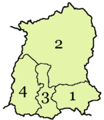
Sikkim is divided into four main districts. Each one has its own unique features and is an important part of the state. These districts help organize the land and people of Sikkim.
East Sikkim District
The East Sikkim district is home to Gangtok, which is the capital city of Sikkim. It's a busy and important area.
- Headquarters: Gangtok
- Population (2011): 281,293 people
- Area: 954 square kilometers
North Sikkim District
North Sikkim is the largest district in terms of area. It has fewer people living there because much of it is covered by mountains and forests.
- Headquarters: Mangan
- Population (2011): 43,354 people
- Area: 4,226 square kilometers
South Sikkim District
South Sikkim is known for its pleasant weather and beautiful views. It's a popular place for both locals and visitors.
- Headquarters: Namchi
- Population (2011): 146,742 people
- Area: 750 square kilometers
West Sikkim District
West Sikkim is famous for its historical sites and natural beauty. It's a great place to explore ancient monasteries and stunning landscapes.
- Headquarters: Geyzing
- Population (2011): 136,299 people
- Area: 1,166 square kilometers
Quick Facts About Sikkim's Districts
This table gives you a quick look at the four districts of Sikkim. It shows their codes, headquarters, how many people live there, their size, and how many people live per square kilometer.
| Code | District | Headquarters | Population (2011) | Area (km²) | Density (/km²) | Map |
| ES | East Sikkim district | Gangtok | 281,293 | 954 | 257 |
 |
| NS | North Sikkim district | Mangan, India | 43,354 | 4,226 | 10 |
 |
| SS | South Sikkim district | Namchi | 146,742 | 750 | 175 |
 |
| WS | West Sikkim district | Geyzing | 136,299 | 1,166 | 106 |
 |
