List of districts in Uttarakhand facts for kids
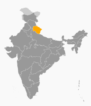
Uttarakhand is a beautiful state in India. To help manage everything, the state is divided into smaller areas called districts. Think of a district like a big neighborhood or a county. Each district has its own leaders and teams that help run things smoothly for the people living there.
The main leader of a district is called the District Collector or District Magistrate. This person is like the head manager for the whole district. They make sure laws are followed and that public services work well. Many other officers help them, like assistant collectors and local administrators called tehsildars.
Keeping everyone safe is a big job! The Superintendent of Police is in charge of the police force in the district. Their main role is to make sure law and order are kept, so everyone can feel secure.
Uttarakhand is known for its amazing forests and wildlife. A special officer called the Deputy Conservator of Forests looks after the forests, protects the environment, and cares for the wild animals in the district. They work with other forest officials to keep nature healthy.
Besides these main leaders, there are also heads for different important areas. For example, there are officers who manage roads (Public Works Department), health services, schools, farming, and animal care. These people work together to make sure the district has everything its residents need.
The government is always looking for ways to improve how districts are managed. Because of this, there are plans to create a few new districts in Uttarakhand, like Ranikhet, Didihat, Kotdwar, and Yamunotri.
Meet the Districts of Uttarakhand
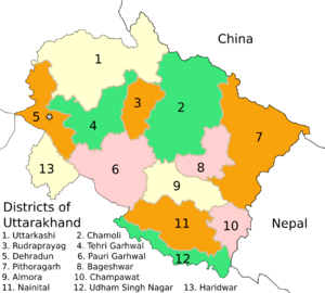
Uttarakhand has 13 districts, each with its own unique features. This table shows you some important facts about them, like their main town, how many people live there, and how big they are.
| Code | District | Headquarters | Population (2011) | Area (km²) | Density (/km²) | Division | Map |
|---|---|---|---|---|---|---|---|
| AL | Almora | Almora | 621,972 | 3,083 | 202 | Kumaon |  |
| BA | Bageshwar | Bageshwar | 259,840 | 2,302 | 113 | Kumaon |  |
| CL | Chamoli | Gopeshwar | 391,114 | 8,030 | 51 | Garhwal |  |
| CP | Champawat | Champawat | 259,315 | 1,781 | 146 | Kumaon |  |
| DD | Dehradun | Dehradun | 1,695,860 | 3,088 | 550 | Garhwal |  |
| HA | Haridwar | Haridwar | 1,927,029 | 2,360 | 817 | Garhwal |  |
| NA | Nainital | Nainital | 955,128 | 3,860 | 247 | Kumaon |  |
| PG | Pauri Garhwal | Pauri | 686,572 | 5,399 | 127 | Garhwal |  |
| PI | Pithoragarh | Pithoragarh | 485,993 | 7,100 | 68 | Kumaon |  |
| RP | Rudraprayag | Rudraprayag | 236,857 | 1,890 | 125 | Garhwal |  |
| TG | Tehri Garhwal | Tehri | 616,409 | 4,080 | 151 | Garhwal |  |
| US | Udham Singh Nagar | Rudrapur | 1,648,367 | 2,908 | 567 | Kumaon |  |
| UT | Uttarkashi | Uttarkashi | 329,686 | 8,016 | 41 | Garhwal |  |
Future Districts
To make managing the state even better, there are plans to create some new districts. These new districts would be formed by taking parts from existing ones. Here are some of the proposed new districts:
- Didihat, which would be created from parts of Pithoragarh district.
- Kashipur, which would be created from parts of Udham Singh Nagar district.
- Kotdwar, which would be created from parts of Pauri Garhwal district.
- Ramnagar, which would be created from parts of Nainital district.
- Ranikhet, which would be created from parts of Almora district.
- Rishikesh, which would be created from parts of Dehradun district, Tehri Garhwal district, and Pauri Garhwal district.
- Roorkee, which would be created from parts of Haridwar district.
- Yamunotri, which would be created from parts of Uttarkashi district.
 | Dorothy Vaughan |
 | Charles Henry Turner |
 | Hildrus Poindexter |
 | Henry Cecil McBay |


