
List of historic places in Moncton facts for kids

Welcome to Moncton, New Brunswick! This city is full of amazing places that tell stories about its past. These special spots are called historic places. They are important because they help us remember how Moncton grew and changed over many years.
These places are officially recognized on the Canadian Register of Historic Places. This means they are protected and celebrated for their history. They can be buildings, parks, or even parts of the landscape. Let's explore some of Moncton's most interesting historic sites!
Contents
Discover Moncton's Historic Landmarks
Moncton has many buildings and areas that are important to its history. Each one has a unique story to tell.
Grand Buildings and Architecture
Many historic buildings in Moncton show off beautiful old designs. They remind us of how people lived and worked long ago.
This building's front (façade) is a piece of Moncton's history. It was once part of the city hall built in 1916. Today, it stands as a reminder of the city's past government buildings.

This beautiful building used to be a school. Now, it's a lively place where artists create and share their work. It's a hub for culture and creativity in Moncton.

- Albion Block
Located on Main Street, the Albion Block is an old commercial building. It shows the kind of architecture that was popular when Moncton was growing.
This tall tower is a landmark in Moncton. While it might seem modern, it's recognized for its role in the city's development and communication history.

- Bank of Montreal Building
This building once housed a major bank. Its design reflects the importance of banks in the city's economy during earlier times.
The Capitol Theatre is a stunning old theatre on Main Street. It has been a place for shows and entertainment for many years. It's a great example of how people enjoyed themselves in the past.

- Cathédrale Notre-Dame de l'Assomption
This large and beautiful cathedral is a very important religious building in Moncton. Its impressive size and design make it a key historic site.

- Doyle Building
The Doyle Building is another historic commercial building. It adds to the charm of Moncton's older streets and shows the city's business past.

- Federal Building, Dominion Public Building
This large building once served as a federal government office. It's a significant example of public architecture from its time.

- First Moncton United Baptist Church
This church has been a place of worship for a long time. Its architecture and history are important to the community.

- Flat Iron Building
Like other "flat iron" buildings, this one has a unique triangular shape. It's an interesting piece of urban design from Moncton's past.
.jpg)
- Former Moncton and Regional Public Library
This building used to be the main public library for Moncton. It played an important role in education and community life.

- Highfield Street United Baptist Church
Another historic church, this building is known for its beautiful design and long history within the Moncton community.

- Killam House
The Killam House is a historic residence that shows how some families lived in Moncton long ago. It's a good example of older home styles.

- Masonic Temple
The Masonic Temple is a building with unique architecture. It was built for the Freemasons, a fraternal organization, and has a rich history.

- McSweeney Building
This commercial building on Main Street is another example of Moncton's early business architecture.

- Moncton Free Meeting House
This special building was built for different religious groups to meet and worship. It's a symbol of religious freedom and community spirit in Moncton's early days.

- No. 2 Fire Station
This old fire station is a cool piece of history. It reminds us of how emergency services used to operate in the city.

- Peters House
The Peters House is a historic home that gives us a peek into the past lives of Moncton residents.

- Royal Bank Building
This grand building once housed a Royal Bank branch. Its design shows the importance of financial institutions in the city's growth.

- Rubin's Ltd. Mural
This mural on the side of a building tells a story through art. It's a unique way to preserve history and local culture.

- St. Bernard's Church and Rectory
This church and its rectory (the priest's house) are important religious and architectural sites in Moncton.

- St. George's Anglican Church
Another significant church, St. George's Anglican Church, has been a part of Moncton's spiritual life for many years.

- Tiferes Israel Synagogue
This synagogue is a historic place of worship for the Jewish community in Moncton. It represents the diverse history of the city.

- Transcript Building
This building was once home to the local newspaper, the Transcript. It played a big role in sharing news and information with the community.

- Treitz Haus
The Treitz Haus is a very old house that gives us a glimpse into early settler life in Moncton.

- Victoria Park, New Brunswick
Victoria Park is a beautiful green space in the city. It's not just a park; it's a historic landscape where people have gathered for generations.

- Thomas Williams House
This house is a well-preserved example of historic residential architecture in Moncton. It's named after a notable person from the city's past.
_(cropped).jpg)
Natural and Public Historic Sites
Moncton also has historic places that are natural areas or public spaces, important for different reasons.
- The Bend
This area near the Petitcodiac River is historically significant because it was a key point for early settlement and trade. The river itself was vital to Moncton's growth.

- Bore Park
Bore Park is famous for the Tidal Bore, a natural phenomenon where the Bay of Fundy's high tide rushes up the Petitcodiac River. The park is a historic viewing spot for this amazing sight.

Magnetic Hill is a famous natural attraction where it seems like cars roll uphill on their own! It's a fun and historic spot that has amazed visitors for years.

- Irish Families Memorial
This memorial in Riverfront Park honors the Irish families who settled in Moncton. It's a place to remember their contributions to the city's history.

- Settlers' Landing Monument
This monument marks the spot where early settlers first arrived in the Moncton area. It's a key site for understanding the city's beginnings.

Images for kids
-
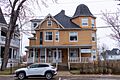
A historic home at 69 Highfield Street.
-
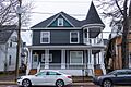
Another historic residence at 73 Highfield Street.


See also
