
List of national monuments in County Wicklow facts for kids
The Irish government has officially chosen many special places in County Wicklow to be protected as national monuments. These are like super important historical sites or buildings that tell us a lot about Ireland's past. If a place is called a "national monument," it means it's really important for the whole country, and the government helps keep it safe. Sometimes, even the land around the monument is protected too, to make sure the monument stays safe and sound.
Contents
Amazing Places in Wicklow
County Wicklow is full of incredible historical sites! Let's explore some of these special places that are protected as national monuments.
Ancient Churches and Abbeys
Many old churches and abbeys in Wicklow are national monuments. These buildings show us how people lived and worshipped hundreds of years ago.
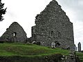
Aghowle Church

In a place called Aghowle Lower, you can find the ruins of Aghowle Church. This old church, along with a cross, is a reminder of early Christian times in Ireland.
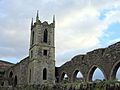
Baltinglass Abbey

Baltinglass Abbey is a Cistercian abbey located in Baltinglass. Cistercian monks were a special group of monks who lived very simple lives. This abbey was built a long, long time ago and is a beautiful example of old Irish architecture.
Kilcoole and Kilcroney Churches

There are also old churches in Kilcoole and Kilcroney. These churches, like Kilcoole Church and Kilcroney Church, tell stories of communities that lived there centuries ago.
Raheenachluig Church

Near Newcourt, you'll find Raheenachluig Church. This ancient church is another important historical site in Wicklow.
St. Mary's Church, Downsmill

In Woodlands, there's St. Mary's Church, Downsmill, which dates all the way back to the 11th century! Imagine how much history these walls have seen.
Mysterious Stone Circles and Tombs
Wicklow is home to some very old stone structures, like stone circles and tombs, built by people thousands of years ago. We're still learning about their purpose!
Piper's Stones

At Athgreany, you can visit the Piper's Stones, which is a stone circle. Stone circles are mysterious rings of standing stones that ancient people built. We think they might have been used for ceremonies or to track the sun and moon.
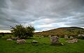
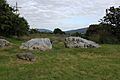
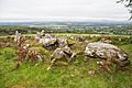
Castleruddery Stone Circle

Another amazing stone circle is the Castleruddery Stone Circle in Castleruddery Lower. These circles are fascinating because they show us how clever ancient people were.
Moylisha Wedge Tomb

In Moylisha, there's a Moylisha Wedge Tomb. These are ancient burial places, often shaped like a wedge, where people were buried thousands of years ago.
Seefin Passage Tomb

The Seefin Passage Tomb in Scurlocksleap is another type of ancient burial site. It has a long passage leading to a burial chamber, often covered by a mound of earth.
Rathcoran Passage Tomb

Rathcoran is a special place that includes both a passage tomb and a hillfort. It's located across Coolinarrig Upper, Pinnacle, and Tuckmill Hill.
Impressive Forts and Castles
Wicklow also has many old forts and castles that were built for protection or as homes for important people.
Crossoona Rath
Crossoona Rath in Boleycarrigeen is a ringfort. Ringforts are circular areas surrounded by banks and ditches, built a long time ago for homes and protection. This one also has an Ogham Stone, which is a stone with ancient Irish writing carved into it.
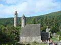
Glendalough

One of the most famous sites is Glendalough. It's a huge historical area with a cathedral, a tall Round Tower, many churches, a priory (which is like a monastery), crosses, a ringfort, and even a hut site and a cave! It's a truly amazing place to explore.
Castleruddery Motte
A "motte" is a type of small hill, often man-made, that had a wooden tower or castle built on top for defense. Castleruddery Motte is found in Castleruddery Lower.
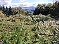
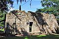
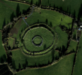
Rath Turtle Moat

Rath Turtle Moat in Deerpark is another ringfort. These sites show us how people lived and defended themselves in ancient Ireland.
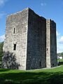
Kindlestown Castle

In Kindlestown Upper, you can find Kindlestown Castle. Castles were strong buildings used by lords and kings, often for protection and as a symbol of power.
Lemonstown Motte

Another motte, Lemonstown Motte, is located in Lemonstown. These small hills were important defensive structures.
Rathgall Hillfort
Rathgall in Rath is a large hill fort. Hillforts were big settlements or defensive sites built on hills, often surrounded by walls or ditches.
Threecastles Castle

Near Blessington, you'll find Threecastles Castle. This castle is another example of the strongholds that once dotted the Irish landscape.
Tornant Moat
Tornant Moat in Tornant Lower is a ringfort with barrows, which are ancient burial mounds.
Other Important Monuments
St. Mark's Cross

In Burgage More, there is St. Mark's Cross, which is a high cross. High crosses are tall, decorated stone crosses that are very important in early Irish Christian art and history.
Castletimon Ogham Stone
The Castletimon Ogham Stone in Castletimon is a stone with ancient Irish writing called Ogham. This writing uses lines and notches carved into the edge of a stone.
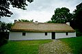
Dwyer–McAllister Cottage

In Derrynamuck (Donard), you can find the Dwyer–McAllister Cottage. This house is important because of its historical connections, telling a story about people and events from the past.
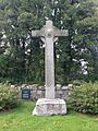
Fassaroe Cross

The Fassaroe Cross is located in Fassaroe, Bray. This cross is another example of the historical markers found throughout Wicklow.
Images for kids
-
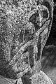
Aghowle Church and Cross
-
The ancient Piper's Stones at Athgreany
-
The beautiful ruins of Baltinglass Abbey
-
The famous Round Tower at Glendalough
-
St. Mark's Cross, a tall stone cross
-
The impressive Castleruddery Stone Circle
-
The top of Rath Turtle Moat
-
Dwyer–McAllister Cottage, a house with historical importance
-
Fassaroe Cross
-
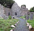
The historic Kilcoole Church
-
Kilcroney Church ruins
-
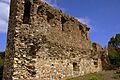
The ruins of Kindlestown Castle
-

Lemonstown Motte
-
The ancient Moylisha Wedge Tomb
-
Raheenachluig Church, an ancient church ruin
-
Rathgall Hillfort, an ancient defensive site
-
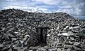
The entrance to Seefin Passage Tomb
-
Threecastles Castle
-

St. Mary's Church, dating back to the 11th century

More Information
If you want to learn even more about these amazing places, you can check out the official list of national monuments in County Wicklow from the National Monuments Service.
