
List of prehistoric scheduled monuments in south Pembrokeshire facts for kids
Pembrokeshire might be the fifth-largest county in Wales, but it's packed with history! It has the second-highest number of scheduled monuments in Wales, with 526 amazing sites. This means there are about 33 monuments for every 100 square kilometers, which is a lot!
Pembrokeshire is located at the very western end of Wales, with most of its border touching the sea. It used to be its own historic county. For a while, between 1975 and 1996, it was part of a bigger county called Dyfed.
More than two-thirds of Pembrokeshire's protected sites, about 346 of them, are from prehistoric times. These are places like ancient forts, burial mounds, and mysterious standing stones. There are so many that they are split into different lists to make it easier to explore. One list covers sites from Roman times up to today. The prehistoric sites are divided into two lists: one for north Pembrokeshire and one for south Pembrokeshire. This article focuses on the 112 prehistoric sites found in south Pembrokeshire.
The other 182 sites in Pembrokeshire are from Roman, medieval, and more recent times. These include things like old castles, churches, and even structures from World War II.
Scheduled monuments are very important because they are protected by law. This means they can't be damaged or changed. The Welsh government agency called Cadw helps to find and protect these special places. They work with other groups like RCAHMW and Dyfed Archaeological Trust to keep track of all these historical treasures.
Contents
Discovering Ancient Sites in Pembrokeshire
Pembrokeshire is like a giant outdoor museum, filled with clues about how people lived thousands of years ago. These clues are called scheduled monuments.
What are Scheduled Monuments?
Scheduled monuments are important historical sites that are protected by law. They can be anything from ancient burial places to old castles or even wartime buildings. They help us understand the past.
Pembrokeshire's Ancient Treasures
Many of Pembrokeshire's scheduled monuments are from prehistoric times. This means they were built before written history began. These sites include different kinds of forts, burial places, and mysterious stone structures.
Hill Forts and Camps
Ancient people often built strong defenses to protect themselves. In Pembrokeshire, you can find:
- Hill forts: These were large settlements built on top of hills, using the natural height for defense. An example is Foel Drygarn Camp.
- Promontory forts: These were built on headlands or cliffs, often by the coast or on bends in rivers. The natural steep drops on three sides made them very hard to attack.
- Enclosures: These are areas of land surrounded by banks and ditches. They were used for homes, farms, or even as meeting places. Some, like Trelissey, even had Roman villas built inside them later!
- Raths: These are a type of circular enclosure, often with a ditch and bank, used as homes or farms.
Burial Sites
People in prehistoric times had special ways to bury their dead. You can find:
- Chambered tombs: These are ancient stone structures where people were buried. They often have a main chamber and a passage leading to it. Examples include Devil's Quoit Burial Chamber and King's Quoit.
- Round barrows: These are circular mounds of earth or stone built over burials. They are also called tumuli. Many examples are found across Pembrokeshire, like Rhos Goch Round Barrow.
- Platform cairns: These are flat, raised mounds of stones, often used for burials or rituals.
Standing Stones and Stone Circles
Some of the most mysterious ancient sites are made of large stones:
- Standing stones: These are single, tall stones placed upright by ancient people. We don't always know why they were put there, but they might have marked important places or been used for ceremonies.
- Stone circles: These are groups of standing stones arranged in a circle. They were likely used for religious ceremonies or to track the sun and moon. A famous example is Gors Fawr Stone Circle.
- Stone rows: These are lines of standing stones.
Caves and Other Sites
Pembrokeshire also has other ancient sites:
- Caves: Some caves, like Hoyle Mouth Cave and Nanna's Cave, were used by early humans for shelter or other activities thousands of years ago.
- Burnt mounds: These are piles of heat-cracked stones, often found near water. They are thought to be ancient cooking sites or places where water was heated for bathing.
- Hut groups: These are areas where the remains of ancient huts can be seen, showing where people lived together.
These sites offer a fascinating look into the lives of people who lived in Pembrokeshire long, long ago.
Images for kids
-
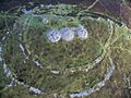
Foel Drygarn camp
-
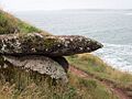
King's Quoit
-
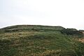
Greenala Camp


.jpg)
See also
