
List of stone circles in the Scottish Borders facts for kids
A stone circle is a special type of ancient monument. It is usually made of standing stones arranged in a circle. These mysterious circles were built a very long time ago, often in the Bronze Age or Neolithic period. People are not entirely sure why they were built. They might have been used for ceremonies, burials, or even to track the sun and moon.
The Scottish Borders area of Scotland is home to many of these fascinating stone circles. Experts have found 16 stone circles here. Some are very well-preserved, while others are just possible sites.
Famous Stone Circles
Some of the best-preserved stone circles in the Scottish Borders include:
- Borrowston Rig
- Burgh Hill
- Five Stanes
- Harestanes
- Ninestane Rig
- Yadlee
Exploring Stone Circles in the Borders
There are several stone circles spread across the Scottish Borders. Each one has its own unique story, even if we don't know all the details. Here are some of them:
- Borrowston Rig: This circle is found in the area of Lauder.
- Burgh Hill: Located near Teviothead, this is another well-known stone circle.
- Cloyhouse Burn: This is a possible stone circle site near Stobo.
- Five Stanes: Found in Hownam, this circle is one of the more visible ones.
- Five Stone Field: Another site in the Linton area.
- Harelaw, Fairnington: This circle is located near Roxburgh.
- Harestanes: Situated near Kirkurd, this is a notable stone circle.
- Harestanes Cottages: Another site found near Ancrum.
- Kirktonhill: This circle is in the Channelkirk area.
- Megget Reservoir: Located near Yarrow, this site is close to the reservoir.
- Ninestone Rig: This is a very famous stone circle near Castleton. It's known for its nine stones.
- Oxnam Parish: There are possible stone circle sites in this area.
- Plenderleith: Another circle found near Oxnam.
- Redden: This is a possible "four poster" stone circle near Sprouston.
- Stobo Mill: A possible stone circle site near Stobo.
- Yadlee: This well-preserved circle is located near Spott.
See also
- Stone circles in the British Isles and Brittany
- List of stone circles in Dumfries and Galloway
- List of stone circles
Images for kids
-
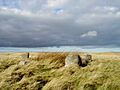
The Five Stanes Stone Circle.
-
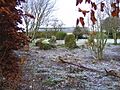
The Harestanes Stone Circle.
-
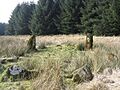
The Ninestane Rig Stone Circle.


