
List of windmills in Kent facts for kids
Kent, a county in England, is famous for its beautiful countryside and rich history. One interesting part of its history is the many windmills that once dotted its landscape. These tall structures used the power of the wind to grind grain into flour, pump water, or saw wood.
Windmills come in different types. A post mill is one of the oldest types, where the entire body of the mill turns on a large central post to face the wind. A smock mill has a fixed tower, usually with eight sides, and only its cap (the top part with the sails) turns. A tower mill is similar but has a round, brick or stone tower. There are also special types like the hollow post mill for pumping water, and rare horizontal windmills where the sails spin horizontally.
This list explores the windmills that have stood in Kent, from ancient times to today. Some are still standing, perhaps as homes or museums, while others are just memories.
Contents
- Windmills in Kent: A-Z Guide
- Aldington
- Appledore
- Ash (near Sandwich)
- Badlesmere
- Barham
- Benenden
- Bethersden
- Bidborough
- Biddenden
- Broadstairs
- Canterbury
- Charing
- Chatham
- Chillenden
- Chislet
- Cobham
- Cranbrook
- Dartford
- Deal
- Doddington
- Dover
- Eastry
- Edenbridge
- Folkestone
- Frindsbury
- Guston
- Harbledown
- Headcorn
- Herne
- Higham
- High Halden
- Hildenborough
- Iwade
- Kingston
- Leigh
- Lydd
- Margate
- Meopham
- Newchurch
- Newington (Thanet)
- New Romney
- Northbourne
- Oare
- Ospringe
- Pluckley
- Preston-next-Faversham
- Preston-next-Wingham
- Ramsgate
- Ringwould
- Rochester
- Rodmersham Green
- Rolvenden
- Sandhurst
- Sandwich
- Sarre
- Selling
- Sheerness
- Shorne
- Smarden
- Stanford
- Staple
- Staplehurst
- Stelling Minnis
- St Margaret's Bay
- Stodmarsh
- Strood
- Sutton Valence
- Swingfield
- Tenterden
- Throwley
- Upchurch
- Uphill
- Waltham
- West Kingsdown
- Whitstable
- Willesborough
- Wittersham
- Woodchurch
- Wye
- Images for kids
- Maps
- See also
Windmills in Kent: A-Z Guide
Aldington
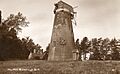
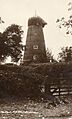
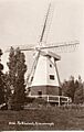
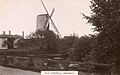
- Aldington Mill was a smock mill built around 1878. It stopped working around 1908 and was taken down in 1910. Its base is still there and is used as a storage building.

Appledore
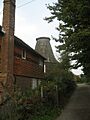
- The Great Mill, also known as Union Mill, was a smock mill built in 1791. It was taken down in 1909, but its base is still standing and has been turned into a house.
Ash (near Sandwich)
- Mount Ephraim Mill was a post mill built in 1818. It was moved from Woodnesborough. Sadly, a strong wind blew it down on October 28, 1955.
Badlesmere
- Boundgate Mill was a smock mill built in 1872. It worked until 1921 and was taken down in 1938. Its base is still used for storage.
Barham
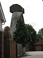
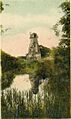
- The Black Mill was a smock mill built in 1834. It burned down on March 3, 1970. Only its ruined base remains.

Benenden
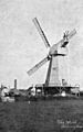
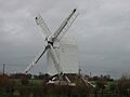
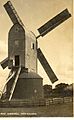
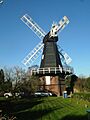
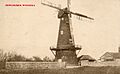
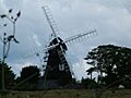
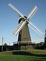
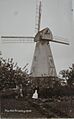
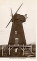
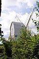
- Beacon Mill (north) is a smock mill built in 1821. It worked until 1921 and is still standing today.

Bethersden
- White Mill was a smock mill that worked until 1923. It was blown down in 1937.

Bidborough
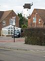
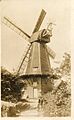
- Bidborough Mill is a tower mill built in 1858. It worked until about 1900 and was turned into a house in 2006.

Biddenden
- Town Mill was a smock mill that worked until 1914. People lived in it during the 1930s, but it collapsed in 1946.

Broadstairs
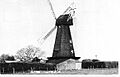
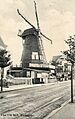
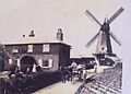
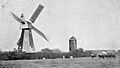
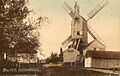
- Pierremont Mill, also called Bradstowe Mill, was a smock mill built in 1827. It worked until 1907 and was taken down in 1909.

Canterbury
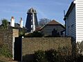
- St Martin's Mill is a tower mill built in 1817. It worked until 1890 and was converted into a house in 1920.

- St Martin's Black Mill was a smock mill built in 1816. It was taken down in 1868.

Charing
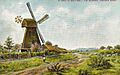
- Charing Mill, also known as Field Mill, is a smock mill built in 1821. It worked until 1891 and has since been converted into a house.

Chatham
- Star Mill, also called Upper Chatham Hill Mill, was a smock mill that was taken down in 1925.

- Field's Mill was a smock mill built in 1837. It worked until 1887, when it was taken down.
- Ordnance Place Mill, also known as Belsey's Mill, was a smock mill built in 1845. It was used to grind corn and pump water. It was taken down around 1900.

Chillenden
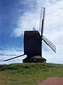
- Chillenden Mill is a post mill that was first built around 1695. It was blown down in 1868. A new post mill was built in 1868, but it collapsed on November 26, 2003. A rebuild of the mill was completed in 2005.

Chislet
- Chislet Mill was a smock mill built in 1744. It sadly burned down on October 15, 2005.
- Chislet Mock Mill is a residential mock mill built in 2012. It looks like a smock mill but is a home.

Cobham
- Darnley's Mill was a smock mill built in 1852. It was struck by lightning and burned down in 1903. Its base is still there and has been converted into a house.
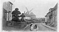
Cranbrook
- Union Mill is a smock mill built in 1814. It worked until 1957 and was restored between 1958 and 1960. It is the tallest smock mill in the United Kingdom!

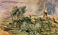
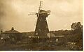
- Cranbrook Common Mill was a smock mill built in 1872. It worked until 1876 and was taken down on August 9, 1901.

Dartford
- Brent Mill was a smock mill built in 1799. It worked until 1886 and was taken down around 1901.

Deal
- Upper Deal Mill was a smock mill built in 1855. It was taken down in March 1929.

Doddington
- Jarvis's Mill, also known as Elvey's Mill, was a smock mill built around 1820. It was taken down in 1937.
Dover
- The Buckland Brewery had a smock mill built in 1798. It was used to pump water and was taken down in the 1890s.

Eastry
- Upper Mill is a smock mill built in 1769. It worked by wind until 1913, then by a gas engine until 1959. It has since been converted into a house.

Edenbridge
- Edenbridge Mill is a tower mill built in 1815. It worked until 1886 and was converted into a house in the 1990s.

Folkestone
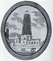
- Folkestone Mill, also called Foord Road Mill, was a mill built in 1769. It was still standing in 1833.

Frindsbury
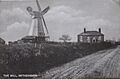
- Nightingale's Mill, also known as Four Throws Mill, was a smock mill moved from Gun Green around 1870. It was taken down in 1926.

Guston
- Swingate Mill is a tower mill built in 1849. It worked until 1959 and has since been converted into a house.

Harbledown
- The Old Black Mill was a smock mill built in 1780. It worked until the 1890s and was taken down on July 9, 1913.
.jpg)
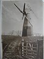
Headcorn
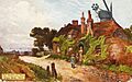
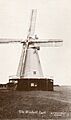
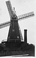
- White Mill was a smock mill built in 1819. It was still working in 1933 and was taken down in 1952.

Herne
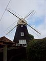
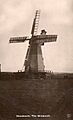
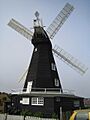
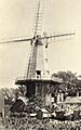
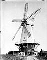
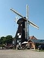
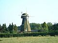
- Herne Windmill is a smock mill built in 1781. It worked by wind until 1952, then by an electric motor until 1980. It has since been restored.

Higham
- Rose's Mill was a smock mill built in 1760. It was taken down in April 1921, but its base is still standing.

High Halden
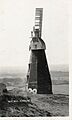
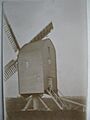
- High Halden Mill was a post mill moved around 1800. It worked until about 1918 and was taken down by 1933.

Hildenborough
- Watt's Cross Mill was a smock mill built in 1812. It worked until 1910 and was taken down in 1961, leaving a ruined base.

Iwade
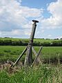
- Iwade Windpump is a hollow post mill. It was a windpump, and some parts of it were still there in 1973.
Kingston
- Reed Mill is a tower mill built in 1872. It worked until March 28, 1915, and was converted into a house between 2009 and 2010.

Leigh
- Stocks Green Mill was a smock mill moved from Sidley, East Sussex, in 1928. It collapsed around 1963.
Lydd
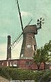
- New Mill was a smock mill built in 1805. It worked until 1920, later using a steam engine. It burned down on September 22, 1927.
.jpg)
- White Mill was a smock mill built around 1852. It was taken down in 1920.

Margate
- Drapers Mill, also known as Old Mill, is a smock mill built around 1847. It is still standing.

- Little Draper's Mill was a smock mill moved from Barham around 1869. It was still standing in 1903 but was gone by 1933, though its base remained.

- Hooper's Mill was a horizontal windmill built in 1791. It was taken down around 1828.

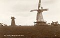
Meopham
- Meopham Mill is a smock mill built in 1801. It worked by wind until 1929, then by an engine until 1965. It has since been restored.

Newchurch
- Newchurch Mill was a tower mill built in 1810. It was taken down around 1906, but its stump remains.

Newington (Thanet)
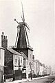
- Newington Mill was a smock mill built in 1843. It was still standing in 1933.

New Romney
- New Romney Mill, also called Old Mill, was a smock mill built in 1769. It was still standing in 1903 but was gone by 1933.

Northbourne
- New Mill is a smock mill built in 1848. It worked by wind until 1949, then by an electric motor until 1957. It was converted into a house in 1976.

Oare
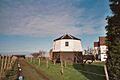
- Oare Windmill is a tower mill built in 1821. It was converted into a house in 1963.

Ospringe
- Water Lane Mill was a smock mill built in 1878. It was taken down around 1915.

Pluckley
- Pluckley Mill was a smock mill built in 1872. It worked until 1916 and burned down in 1939.

Preston-next-Faversham
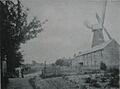
- Preston Mill was a smock mill built in 1843. It worked until 1919, later using a steam engine. It was taken down in 1943.

Preston-next-Wingham
- Dunn's Mill, also called Old Mill, was a smock mill built in 1778. It worked by wind until 1916, then by an engine into the 1930s. It was taken down in 1959, leaving its base.
Ramsgate
- Grange Road Mill was a smock mill built in 1843. It was still standing in 1905 but was taken down by 1930, though its base remained. The base was taken down by 1973.

Ringwould
- Ripple Mill is a smock mill built around 1810. It worked until World War II. Its machinery was removed in 1957, and it was used as a transmitter station. It has been under restoration since 1994.

Rochester
- Delce Mill was a smock mill built in 1853. It was taken down in May 1946.

Rodmersham Green
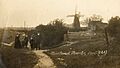
- Rodmersham Green Mill was a tower mill built in 1835. It worked until 1917 and was taken down in 1969.

Rolvenden
- Rolvenden Mill is a post mill built around 1580. It worked until about 1885 and was restored in 1957.

Sandhurst
- Ringle Crouch Green Mill is a smock mill built in 1844. It worked until 1912 and was taken down in 1945, leaving its base. A modern house that looks like a mill and generates electricity was built on the base in 1997.

Sandwich
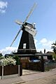
- White Mill is a smock mill built in 1760. It worked by wind until 1926, then by an engine until 1957. It was restored in the 1960s.

- Millwall Mill, also called Town Mill, was a smock mill built in 1878. It burned down at an unknown date.

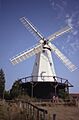
Sarre
- Sarre Windmill is a smock mill built in 1820. It worked by wind until 1920, then by a gas engine for a few more years. It was restored between 1986 and 1991.

Selling
- Perry Wood Mill, also called Shottenden Mill, was a post mill built in 1596. It worked until 1910 and was taken down around 1920.

Sheerness
- Great Mill, also known as Ride's Mill, is a smock mill built in 1816. It worked by wind until 1905, then by a steam engine until 1918. It was taken down in 1924, leaving its base. A residential mock mill was built on the base between 2006 and 2008.

- Hundred Acre Mill, also called Marine Town Mill, was a tower mill built in 1860. It was taken down in 1878, leaving a stump that is still there.

Shorne
- Shorne Mill was a post mill built in 1736. It worked until 1870 and was converted into an observatory in the 1890s. It burned down in 1952, but some of its main wooden parts were still there in 1986.
Smarden
- West Mill, also called Town Mill, was a post mill built in 1680. It worked until at least 1899 and collapsed in 1953.

Stanford
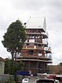
- Stanford Mill is a tower mill built in 1857. It worked by wind until 1946, then by an engine until 1961. It is currently being restored.

Staple
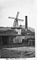
- Barnsole Mill was built in the 1870s. It burned down around 1914.

Staplehurst
- Staplehurst Mill was a smock mill built in 1805. It worked until the 1880s and burned down on June 22, 1911, leaving its base.

Stelling Minnis
- Davison's Mill is a smock mill built in 1866. It worked until 1970 and has since been restored.

St Margaret's Bay
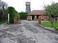
- St Margaret's Bay Mill is a smock mill built in 1929. It was built to generate electricity.
Stodmarsh
- Wickhambreux Mill is a hollow post mill from the mid-19th century.

Strood
- Field's Mill was built in 1843 and burned down around 1875.
- Killick's Mill was a smock mill built in 1843. It was still standing in 1891 but was gone by 1933.
Sutton Valence
- Town Mill was a smock mill built around 1720. It was taken down in 1945, but its base is now part of a house.

Swingfield
- New Mill was a smock mill built in 1885. It burned down in August 1911.
Tenterden
- Ashbourne Mill was a post mill built in 1807. It worked until 1910 and was taken down in December 1912.

- Leigh Green Mill was a smock mill built in 1818. It burned down on November 26, 1913.
Throwley
- Clare's Forstal Mill was a smock mill built in 1872. It was taken down in 1915.

Upchurch
- Wakeley's Mill was a smock mill built in 1843. It burned down in September 1910.

Uphill
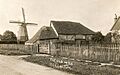
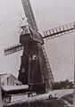
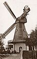
- Uphill Mill, also called Hawkinge Mill, was a smock mill built in 1790. It worked until 1914 and was taken down in May 1931.
Waltham
- Cloke's Mill was a smock mill built in 1872. It worked until the early 1900s and was blown down on February 11, 1931, leaving its base.
- Dilnot's Old Mill was a smock mill built around 1850. It worked until about 1908 and collapsed on May 20, 1910.
West Kingsdown
- Old Mill was a post mill built in 1843. It burned down in May 1909.

- West Kingsdown Mill is a smock mill built in 1880. It is still standing.

Whitstable
- Black Mill is a smock mill built in 1815. It worked until about 1905. It was later converted into a motel and is now a house.

Willesborough
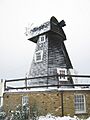
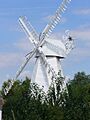
- New Mill is a smock mill built in 1869. It worked by wind until 1938 and was restored in 1991.

Wittersham
- Old Mill was a post mill built in 1736. It was taken down in 1922.

- Stocks Mill is a post mill built in 1781. It worked until about 1900 and was then preserved. It was restored between 2002 and 2004.

Woodchurch
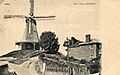
- Upper Mill was a smock mill built in 1769. It worked until 1910 and was taken down in 1940.
.jpg)
- Lower Mill is a smock mill built in 1820. It was moved from Susans Hill Farm. It worked until 1926 and was restored in the 1980s.

Wye
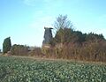
- Wye Windmill was a smock mill built in 1843. It was taken down around 1920. Its base was still standing in 1933 but was taken down in the 1960s.

Images for kids
-
Aldington Mill around 1905
-
Black Mill in Barham
-
Beacon Mill in Benenden
-
White Mill in Bethersden before 1921
-
Bidborough Mill in the 1920s
-
Town Mill in Biddenden around 1907
-
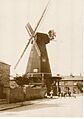
Pierremont Mill in Broadstairs before 1907
-
St Martin's Mill in Canterbury
-
St Martin's Black Mill in Canterbury
-
Charing Mill
-
Star Mill in Chatham
-
Belsey's Mill in Chatham
-
Chillenden Mill
-
Chislet Mock Mill
-
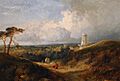
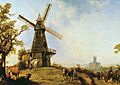
Cranbrook Common Mill in a painting by Niemann
-
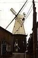
Union Mill in Cranbrook
-
Brent Mill in Dartford
-
Upper Deal Mill in 1907
-
Buckland Brewery Mill in Dover
-
Upper Mill in Eastry
-
Edenbridge Mill in 1917
-
Folkestone Mill in 1833
-
Swingate Mill in Guston
-
The Old Black Mill in Harbledown in 1913
-
White Mill in Headcorn in 1922
-
Herne Windmill
-
Rose's Mill in Higham
-
High Halden Mill in 1913
-
Watt's Cross Mill in Hildenborough in the 1910s
-
Reed Mill in Kingston in 2012
-
New Mill in Lydd before 1920
-
White Mill in Lyminge in 1912
-
Drapers Mill in Margate
-
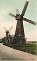
Little Draper's Mill in Margate in 1907
-
Hooper's Mill in Margate
-
Meopham Mill
-
Newchurch Mill before 1906
-
Newington Mill in Ramsgate
-
New Romney Old Mill before 1905
-
New Mill in Northbourne
-
Oare Windmill
-
Water Lane Mill in Ospringe around 1900
-
Pluckley Mill in 1914
-
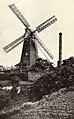
Preston Mill in Preston-next-Faversham around 1905
-
Grange Road Mill in Ramsgate in 1907
-
Ripple Mill
-
Delce Mill in Rochester
-
Rodmersham Green Windmill in 1906
-
Rolvenden Mill
-
Ringle Crouch Green Mill
-
The White Mill in Sandwich
-
Town Mill in Sandwich
-
Sarre Windmill
-
Perry Wood Mill in Selling in 1914
-
Great Mill in Sheerness
-
Hundred Acre Mill in Sheerness
-
West Mill in Smarden before 1912
-
Stanford Windmill
-
Barnsole Mill in Staple
-
Staplehurst Mill
-
Davison's Mill
-
Wickhambreux Mill in Stodmarsh
-
Town Mill in Sutton Valence before 1918
-
Ashbourne Mill in Tenterden
-
Clare's Forstal Mill in Throwley
-
Wakeley's Mill in Upchurch in 1910
-
Old Mill in West Kingsdown in 1906
-
West Kingsdown Mill
-
Black Mill in Whitstable in 1917
-
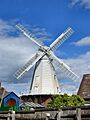
New Mill in Willesborough
-
Old Mill in Wittersham
-
Stocks Mill
-
Upper Mill in Woodchurch around 1912
-
Lower Mill in Woodchurch
-
Wye Windmill
-
Nightingale's Mill in Hawkhurst
Maps
The maps mentioned in the original records are:
- 1414 – Thomas of Elmham (map of Thanet)
- 1596 – Phil Symondson
- 1610 – John Speed
- 1695 – Robert Morden
- 1719 – Dr Harris
- 1736 – Emanuel Bowen
- 1769 – Andrews, Dury and Herbert
- 1829 – Greenwood & Co
See also
