Litchfield, California facts for kids
Quick facts for kids
Litchfield
|
|
|---|---|

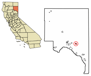
Location of Litchfield in Lassen County, California
|
|
| Country | |
| State | |
| County | Lassen County |
| Area | |
| • Total | 3.945 sq mi (10.217 km2) |
| • Land | 3.945 sq mi (10.217 km2) |
| • Water | 0 sq mi (0 km2) 0% |
| Elevation | 4,065 ft (1,239 m) |
| Population
(2020)
|
|
| • Total | 160 |
| • Density | 40.6/sq mi (15.7/km2) |
| Time zone | UTC-8 (Pacific (PST)) |
| • Summer (DST) | UTC-7 (PDT) |
| GNIS feature IDs | 252725; 2628751 |
Litchfield is a small community in Lassen County, California. It is known as a census-designated place (CDP). This means it is an area identified by the U.S. Census Bureau for gathering statistics. Litchfield is located about 15 kilometers (9 miles) east of Susanville. It sits at an elevation of 1,239 meters (4,065 feet) above sea level. In 2020, its population was 160 people. This was a decrease from 195 people in 2010.
Contents
History of Litchfield
The first post office in Litchfield opened in 1914. A post office is where mail is sorted and sent. This post office later moved in 1941. The community was named to honor an early pioneer named Thomas Litch.
The United States Bureau of Land Management has a special place near Litchfield. It is a corral for wild horses and burros. These animals are gathered from public lands. On October 15, 2001, the hay barn at this facility caught fire.
Geography and Climate in Litchfield
Litchfield is located in Lassen County, California. According to the United States Census Bureau, the entire area of Litchfield is land. It covers about 10.2 square kilometers (3.9 square miles). There are no lakes or rivers within its boundaries.
Litchfield's Climate
Litchfield experiences a specific type of weather pattern. It has warm, but not extremely hot, and dry summers. The average monthly temperatures do not go above 22 degrees Celsius (71.6 degrees Fahrenheit). This kind of weather is called a warm-summer Mediterranean climate. On climate maps, this is often shown as "Csb."
People of Litchfield (Demographics)
| Historical population | |||
|---|---|---|---|
| Census | Pop. | %± | |
| U.S. Decennial Census | |||
In 2010, Litchfield had a population of 195 people. This means there were about 19 people living per square kilometer (49 people per square mile).
Most of the people living in Litchfield were White. About 90.3% of the population identified as White. About 7.2% were from other races. Around 2.6% identified as being from two or more races. About 12.8% of the people were of Hispanic or Latino background.
All the people in Litchfield lived in regular homes. There were 77 households in total. A household is a group of people living together in one home.
- 22 households (28.6%) had children under 18 living there.
- 41 households (53.2%) were married couples.
- 4 households (5.2%) had a female head of household with no husband.
- 10 households (13.0%) had a male head of household with no wife.
The average number of people living in one household was 2.53. There were 55 families, with an average family size of 2.80 people.
Age Groups in Litchfield
The ages of the people in Litchfield varied:
- 46 people (23.6%) were under 18 years old.
- 16 people (8.2%) were between 18 and 24 years old.
- 39 people (20.0%) were between 25 and 44 years old.
- 64 people (32.8%) were between 45 and 64 years old.
- 30 people (15.4%) were 65 years or older.
The median age in Litchfield was 43.9 years. This means half the population was younger than 43.9, and half was older. For every 100 females, there were about 97 males.
There were 94 housing units in Litchfield. A housing unit is a house, apartment, or mobile home. About 67.5% of these homes were owned by the people living in them. The other 32.5% were rented.
See also
 In Spanish: Litchfield (California) para niños
 | Dorothy Vaughan |
 | Charles Henry Turner |
 | Hildrus Poindexter |
 | Henry Cecil McBay |


