Lobos de Tierra facts for kids
|
Isla Lobos de Tierra (Spanish)
|
|
|---|---|

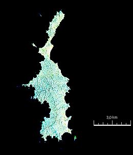
Satellite view of the island.
|
|
|
Location of the island
|
|
| Geography | |
| Location | Pacific Ocean |
| Coordinates | 6°25′40″S 80°51′29″W / 6.42778°S 80.85806°W |
| Area | 16 km2 (6.2 sq mi) |
| Length | 10 km (6 mi) |
| Width | 3 km (1.9 mi) |
| Administration | |
| Region | Lambayeque |
| Additional information | |
| Time zone |
|
Lobos de Tierra is a Peruvian island. It is about 19 kilometers (12 miles) from the mainland. You can find it near the Illescas Peninsula. The island is located close to where the Piura and Lambayeque regions meet. Its area is 16 square kilometers (6.2 square miles). The island is about 10 kilometers (6.2 miles) long and 3 kilometers (1.9 miles) wide.
Wildlife and Natural Treasures
In the past, Lobos de Tierra Island had a lot of guano. Guano is a natural fertilizer made from bird droppings. In 1863, people thought there were almost 7 million metric tons of guano here. They collected it without much control.
Today, most of that guano is gone. The small amount that remains is not as good as it used to be. The island has a very warm climate. It is home to many interesting birds.
You can see kelp gulls, different kinds of boobies, and Guanay cormorants. The boobies include Blue-footed, Nazca, and Peruvian types. The Guanay cormorants and Peruvian boobies were very important when guano was plentiful.
The island's name, Lobos de Tierra, means "land wolves." This name comes from its closeness to the coast and the presence of otariids. Otariids are sea mammals like sea lions and fur seals. Sometimes, even huge blue whales can be seen swimming near the island.
Island Neighbors
Around Lobos de Tierra Island, there are a few smaller islands. These are called islets. Some of these islets include El León and Albatros.
See also
 In Spanish: Isla Lobos de Tierra para niños
- List of islands of Peru
 | Selma Burke |
 | Pauline Powell Burns |
 | Frederick J. Brown |
 | Robert Blackburn |


