Loch Garry (Dalnaspidal) facts for kids
Quick facts for kids Loch Garry |
|
|---|---|

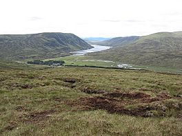
View of
|
|
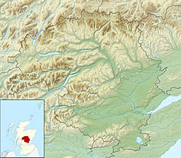
| Coordinates | 56°48′14″N 4°14′42″W / 56.803800°N 4.2451°W |
| Type | freshwater loch |
| Primary outflows | River Garry |
| Max. length | 4.02336 km (2.50000 mi) |
| Max. width | 0.4 km (0.25 mi) |
| Surface area | 164 ha (410 acres) |
| Average depth | 50 ft (15 m) |
| Max. depth | 113 ft (34 m) |
| Shore length1 | 11.2 km (7.0 mi) |
| Surface elevation | 412 m (1,352 ft) |
| 1 Shore length is not a well-defined measure. | |
Loch Garry is a large freshwater loch (which is the Scottish word for a lake) found in Perth and Kinross, Scotland. It's located in the uplands, meaning it's quite high up in the mountains. This beautiful loch is about 4 kilometers (2.5 miles) long and 0.4 kilometers (0.25 miles) wide.
Contents
The Loch Garry Project: Helping Nature
Loch Garry is home to many creatures, including a special type of fish called the arctic char. These fish are usually found in very cold, clear waters.
Why the Loch Needed Help
Back in the early 1970s, a scientist named Ron Greer studied the arctic char in Loch Garry. He found that the loch was becoming "ecologically impoverished." This means the natural environment was losing important parts it needed to be healthy.
The main problem was that a lot of plants, both living and dead, were disappearing from the shallow areas around the edges of the loch. These plants are super important because they provide food, shelter, and breeding grounds for fish and other small creatures. Without them, the arctic char and other wildlife struggled to survive.
How the Project Began
To help fix this problem, the Loch Garry Project was started in 1986. The main goal of this project was to plant trees all around the loch.
How Tree Planting Helps
You might wonder how planting trees helps fish in a loch! Here's how:
- Stopping Soil Erosion: Tree roots hold the soil in place. This stops soil from washing into the loch, which can make the water cloudy and cover up important plant life.
- Providing Shade: Trees provide shade over the water, which helps keep the water cool. Arctic char prefer cooler water.
- Adding Nutrients: Leaves and other plant material from the trees fall into the water. This provides natural food and nutrients for small insects and other organisms that fish eat.
- Creating Habitats: The plants and trees along the shore create a healthy "littoral zone" (the shallow area near the shore). This zone is like a nursery and feeding ground for many aquatic animals.
By planting trees, the Loch Garry Project aimed to bring back the natural balance and help the arctic char population thrive again. It's a great example of how people can work together to protect and restore natural habitats.
 | Jackie Robinson |
 | Jack Johnson |
 | Althea Gibson |
 | Arthur Ashe |
 | Muhammad Ali |


