Loch Moraig facts for kids
Quick facts for kids Loch Moraig |
|
|---|---|

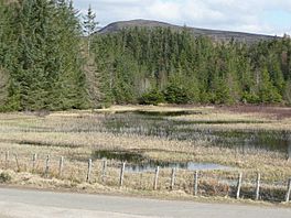
Loch Moraig. This is a reed surrounded lochan linked to the larger loch and ideal for birds and fish. Meall Mor is just visible above the trees on the far side of the lochan.
|
|
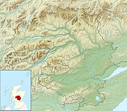
| Coordinates | 56°46′43″N 3°47′24″W / 56.7785°N 3.7899°W |
| Type | freshwater loch |
| Max. length | 0.804 km (0.500 mi) |
| Max. width | 0.402 km (0.250 mi) |
| Surface area | 12.6 ha (31 acres) |
| Average depth | 5.5 ft (1.7 m) |
| Max. depth | 14 ft (4.3 m) |
| Water volume | 8,921,000 cu ft (252,600 m3) |
| Shore length1 | 2.7 km (1.7 mi) |
| Surface elevation | 334 m (1,096 ft) |
| Max. temperature | 57.5 °F (14.2 °C) |
| Min. temperature | 48 °F (9 °C) |
| Islands | 2 |
| 1 Shore length is not a well-defined measure. | |
Loch Moraig is a beautiful freshwater loch (which is the Scottish word for lake). It is located about two miles northeast of a village called Blair Atholl in Scotland.
Interestingly, Loch Moraig wasn't always a lake! It used to be a marshy area where birds called Snipe lived. People built a dam on its southern side to create the lake we see today.
Ancient Homes: Hut Circles
Just a little bit north of Loch Moraig, you can find the remains of very old homes called prehistoric hut circles. These were round or oval houses built by people long, long ago.
These hut circles are now just earth banks. Over many years, wind and rain have worn them down. Archaeologists, who study ancient things, looked at these huts on September 29, 1967.
One of the hut circles, on the west side, is about 8.5 meters (about 28 feet) wide. It's known as a "ring ditch house." The other hut is slightly bigger, about 9.0 meters (about 30 feet) wide, and is shaped like an oval.
Loch Moraig's Surroundings
Loch Moraig is surrounded by amazing mountains. About two miles to the northwest, you can see the four peaks of Beinn a' Ghlò. The closest peak is Carn Liath, which is 975 meters (3,199 feet) tall. Right behind it is Braigh Coire Chruinn-bhalgain, which is even taller at 1,070 meters (3,510 feet).
To the south, about two and a half miles away, is the village of Killiecrankie. A little further, about three miles from Killiecrankie, is the town of Pitlochry.
Directly west of the loch is the small village of Old Blair. Another mountain, Ben Vuirich, stands 903 meters (2,963 feet) tall. It is located about six and a half miles to the northeast.
Walking and Exploring
Loch Moraig is a very popular place for walking and hiking. There are many paths that start from the loch itself or from the Bridge of Tilt, which is just north of Blair Atholl.
These paths lead to different parts of the Beinn a' Ghlò mountain range and also to Ben Vuirich. It's a great spot for adventurers who love to explore the Scottish Highlands!
 | Misty Copeland |
 | Raven Wilkinson |
 | Debra Austin |
 | Aesha Ash |


