
Lœuilly facts for kids
Quick facts for kids
Lœuilly
|
|
|---|---|
|
Part of Ô-de-Selle
|
|

The church in Lœuilly
|
|

Lœuilly
Location in France

Lœuilly
Location in Hauts-de-France
|
|
| Country | France |
| Region | Hauts-de-France |
| Department | Somme |
| Arrondissement | Amiens |
| Canton | Ailly-sur-Noye |
| Commune | Ô-de-Selle |
| Area
1
|
17.21 km2 (6.64 sq mi) |
| Population
(2019)
|
805 |
| • Density | 46.78/km2 (121.15/sq mi) |
| Time zone | UTC+01:00 (CET) |
| • Summer (DST) | UTC+02:00 (CEST) |
| Postal code |
80160
|
| Elevation | 42–152 m (138–499 ft) (avg. 53 m or 174 ft) |
| 1 French Land Register data, which excludes lakes, ponds, glaciers > 1 km2 (0.386 sq mi or 247 acres) and river estuaries. | |
Lœuilly is a small place in northern France. It used to be a separate commune, which is like a small town or village area. But on January 1, 2019, Lœuilly joined with other nearby places to form a new, bigger commune called Ô-de-Selle. It's located in the Somme area, which is part of the Hauts-de-France region.
Contents
Where is Lœuilly Located?
Lœuilly is found about 16 kilometers (10 miles) southwest of a larger city called Amiens. It sits right next to the Selle River, which is a smaller river that flows into the bigger Somme river. In this area, the Selle River splits into many smaller streams and even forms several lakes.
Because of all the water, Lœuilly can sometimes have floods. But don't worry, there are plans and actions in place to help prevent serious flooding.
A Look at Lœuilly's History
People have lived in Lœuilly for a very long time, even during the Gallo-Roman period, which was thousands of years ago! The first people settled near the river, close to a special spring called the Blaire fountain. The water from this spring was thought to be good for digestion and was even sold to people before homes had running water.
Over the centuries, Lœuilly saw some tough times.
- In 1472, soldiers from Burgundy, led by a famous leader named Charles the Bold, destroyed the local castle.
- In 1593, the villagers tried to stop a group called the Catholic League from entering their village. They weren't successful, and part of Lœuilly was burned down.
The strong flow of the Selle River was very useful. Many watermills were built along the riverbanks. Later, these mills became factories, using the river's power to make things. There used to be a large mill pond where the town hall and a car park are today.
From 1876 to 1939, a railway line connecting Beauvais to Amiens ran through Lœuilly. Today, the old railway path is a popular place for people to go for a walk.
Interesting Places to See
Lœuilly has a few cool spots to check out:
- Saint-Martin Church: This church was built in the 1600s. Look closely at its bell-tower – the clock is placed a bit off-center, which is unusual!
- Old Watermills: You can still see several old watermills along the banks of the Selle River, reminding us of the village's past.
How Many People Live Here?
| Historical population | ||
|---|---|---|
| Year | Pop. | ±% p.a. |
| 1962 | 602 | — |
| 1968 | 621 | +0.52% |
| 1975 | 657 | +0.81% |
| 1982 | 831 | +3.41% |
| 1990 | 831 | +0.00% |
| 1999 | 809 | −0.30% |
| 2006 | 832 | +0.40% |
| Source: EHESS | ||
The number of people living in Lœuilly has changed over the years. In 1962, there were 602 people. The population grew to over 800 by the 1980s and has stayed around that number since then. The most recent count in 2019 showed 805 people living there.
Images for kids
-
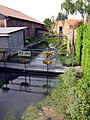
The Selle River flowing through Lœuilly
-
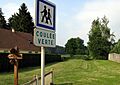
The old railway line, now a walking path


See also
 In Spanish: Lœuilly para niños
