Logansville, Ohio facts for kids
Quick facts for kids
Logansville, Ohio
|
|
|---|---|

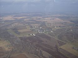
Aerial view of Logansville from the south
|
|

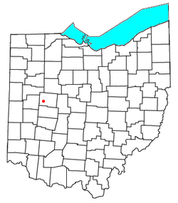
Location of Logansville, Ohio
|
|
| Country | United States |
| State | Ohio |
| County | Logan |
| Township | Pleasant |
| Elevation | 1,007 ft (307 m) |
| Time zone | UTC-5 (Eastern (EST)) |
| • Summer (DST) | UTC-4 (EDT) |
| GNIS feature ID | 1061437 |
Logansville (sometimes spelled Loganville) is a small, quiet community in the state of Ohio, United States. It's known as an "unincorporated community." This means it's a group of homes and businesses that don't have their own local government like a city or a village would. Instead, it's part of a larger area called a township.
Contents
Discover Logansville, Ohio!
Logansville is located in the middle part of Pleasant Township. This township is found within Logan County.
Where is Logansville Located?
You can find Logansville along State Route 47. This main road crosses with County Road 24 right in the community. The Great Miami River flows south along the western side of Logansville.
The community is about 2.5 miles (4 kilometers) north of the village of De Graff. It's also about 9 miles (14.5 kilometers) west of Bellefontaine. Bellefontaine is an important city because it's the county seat for Logan County. This means it's where the main government offices for the county are located.
A Glimpse into History
Logansville was first planned out, or "platted," in the year 1827. When a place is platted, it means its streets and building lots are officially mapped out. The community was named after a famous Native American leader named Logan.
A post office was opened in Logansville in 1835. A post office is where people can send and receive mail. This post office served the community for many years. It stayed open until 1905.
Community Life
Today, Logansville is home to the Logansville Community Church. This church serves as a gathering place for many people in the area. It helps bring the community together.
 | Toni Morrison |
 | Barack Obama |
 | Martin Luther King Jr. |
 | Ralph Bunche |

