
Bellefontaine, Ohio facts for kids
Quick facts for kids
Bellefontaine, Ohio
|
|||||
|---|---|---|---|---|---|

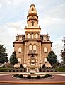
Logan County courthouse in Bellefontaine
|
|||||
|
|||||
| Nickname(s):
The Peak of Ohio
|
|||||

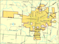
Detailed map of Bellefontaine
|
|||||

Bellefontaine, Ohio
Location in Ohio

Bellefontaine, Ohio
Location in the United States
|
|||||
| Country | United States | ||||
| State | Ohio | ||||
| County | Logan | ||||
| Founded | 1817 | ||||
| Area | |||||
| • Total | 10.10 sq mi (26.17 km2) | ||||
| • Land | 10.10 sq mi (26.17 km2) | ||||
| • Water | 0.00 sq mi (0.00 km2) | ||||
| Elevation | 1,240 ft (380 m) | ||||
| Population
(2020)
|
|||||
| • Total | 14,115 | ||||
| • Estimate
(2023)
|
14,073 | ||||
| • Density | 1,397.11/sq mi (539.42/km2) | ||||
| Time zone | UTC-5 (Eastern (EST)) | ||||
| • Summer (DST) | UTC-4 (EDT) | ||||
| ZIP code |
43311
|
||||
| Area codes | 937, 326 | ||||
| FIPS code | 39-05130 | ||||
| GNIS feature ID | 2394116 | ||||
| Website | ci.bellefontaine.oh.us | ||||


Bellefontaine (pronounced bel-FOWN-tən) is a city in Ohio, United States. It is the main city of Logan County. Bellefontaine is about 48 miles (77 km) northwest of Columbus.
In 2020, about 14,115 people lived here. Bellefontaine is special because it's home to Campbell Hill. This is the highest point in all of Ohio!
Contents
History of Bellefontaine
The name Bellefontaine means "beautiful spring" in French. It got this name because of the many natural springs in the area.
Blue Jacket's Town: An Early Settlement
Around 1777, a Shawnee war chief named Blue Jacket built a village here. It was known as "Blue Jacket's Town." Blue Jacket and his group moved closer to their British allies during the American Revolutionary War.
Later, in 1786, American soldiers destroyed Blue Jacket's Town. This happened during the Northwest Indian War. The soldiers were led by Benjamin Logan, who Logan County is named after. Blue Jacket and his people then moved further away.
In the early 1800s, soldiers from the American Revolution started settling in this area. The government gave them land for their service.
Railroads Come to Town
Bellefontaine was officially planned out in 1820. It became a city in 1835.
In 1837, the first railroad came to Bellefontaine. This made the city known for its railroads. In the 1890s, a big railroad company called the Cleveland, Cincinnati, Chicago and St. Louis Railroad built a large terminal here. It had the biggest roundhouse (a building for turning trains around) between New York and St. Louis.
Even though the railroad industry changed a lot, Bellefontaine is still important for trains. It's where CSX train lines meet, going to Cleveland, Indianapolis, and Dayton.
First Concrete Street and Honda

In 1891, Bellefontaine made history with America's first concrete street. A man named George Bartholomew found a way to pave streets using Portland cement. A small part of Main Street was paved first. When that worked well, Court Avenue was also paved with concrete.
Today, Main Street is asphalt, but Court Avenue still has its original concrete pavement! It has lasted for over 100 years. It's now mostly a walking area, with one lane open for cars.
In 1979, Honda started making motorcycles nearby. Since then, Honda's presence in the Bellefontaine area has grown a lot. Honda is now the biggest employer in Bellefontaine.
Major roads like U.S. Route 68 and U.S. Route 33 also pass through or near the city.
Campbell Hill: Ohio's Highest Point

Campbell Hill was first known as Hogue's Hill. In 1898, Charles D. Campbell bought the land, and the hill was named after him.
In 1950, Campbell Hill was given to the U.S. government. The government used it as a military base from 1951 to 1969. Soldiers there watched for possible attacks from the Soviet Union during the Cold War.
Today, the Ohio Hi-Point Career Center is located on top of Campbell Hill. It's a school that helps students learn job skills.
Geography and Climate
Bellefontaine covers about 10 square miles (26 square kilometers) of land.
The city has four clear seasons. Winters are cool to cold, and summers are usually hot and humid. It gets a good amount of rain all year. Because Bellefontaine is at a higher elevation, it gets more snow than some nearby areas. Its elevation also helps protect it from tornadoes and floods that affect other parts of the region.
Population
| Historical population | |||
|---|---|---|---|
| Census | Pop. | %± | |
| 1820 | 170 | — | |
| 1830 | 266 | 56.5% | |
| 1840 | 475 | 78.6% | |
| 1850 | 1,222 | 157.3% | |
| 1860 | 2,599 | 112.7% | |
| 1870 | 3,182 | 22.4% | |
| 1880 | 3,998 | 25.6% | |
| 1890 | 4,245 | 6.2% | |
| 1900 | 6,649 | 56.6% | |
| 1910 | 8,238 | 23.9% | |
| 1920 | 9,336 | 13.3% | |
| 1930 | 9,543 | 2.2% | |
| 1940 | 9,808 | 2.8% | |
| 1950 | 10,232 | 4.3% | |
| 1960 | 11,424 | 11.6% | |
| 1970 | 11,255 | −1.5% | |
| 1980 | 11,798 | 4.8% | |
| 1990 | 12,142 | 2.9% | |
| 2000 | 13,069 | 7.6% | |
| 2010 | 13,370 | 2.3% | |
| 2020 | 14,115 | 5.6% | |
| 2023 (est.) | 14,073 | 5.3% | |
| Sources: | |||
In 2020, Bellefontaine had a population of 14,115 people. The city is home to people of many different backgrounds. About 90% of the people are White, and about 4% are African American. There are also smaller groups of Asian, Native American, and other races. About 2% of the population is Hispanic or Latino.
Things to See and Do
Interesting Places to Visit
_-_exterior_in_springtime.JPG)


- McKinley Street — This street is known as the "Shortest Street In America." It's only about 20 feet long! While another street in Scotland holds the official world record, McKinley Street is still a fun local landmark.
- Court Avenue — This small street downtown is famous for being the first street in the United States paved with concrete.
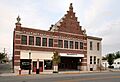
- Holland Theater — This historic theater opened in the 1930s. After closing for a while, it has been beautifully renovated. It now hosts live events and performances for the community.
- Campbell Hill — Don't forget to visit Ohio's highest point!
- First United Methodist Church — This is where famous author and minister Norman Vincent Peale began his career.
Logan County Historical Society
The Logan County Historical Society has a museum. It used to be in an old school building. Now, it's in the Orr mansion, a historic home. The museum shows exhibits about the history of Logan County. It's a great place to learn about the past of the area.
Transportation
The Bellefontaine Regional Airport is located about 5 miles from the city center. It opened in 2002.
Major roads like U.S. Route 68 and U.S. Route 33 help people travel in and out of Bellefontaine.
In the past, Bellefontaine was a stop for passenger trains. The last passenger train service ended in 1971.
Education
The Bellefontaine City Schools system has several schools. These include one elementary school, one intermediate school, one middle school, and one high school. Over 2,800 students attend these schools.
The Ohio Hi-Point Career Center is also in Bellefontaine. It offers job training and higher education programs.
Some colleges also have campuses or programs in the Bellefontaine area. These include Ohio State University, Urbana University, and Clark State Community College.
Bellefontaine also has a public library, which is part of the Logan County Libraries.
Media
Bellefontaine has its own local newspaper, the Bellefontaine Examiner. It has been published since 1831.
There are also several radio stations in the city. These include WPKO (FM), WPKO HD2 (FM), and WBLL (AM). There are also Christian radio stations like WKEN (FM) and WSOH (FM).
Notable People

Many interesting people have connections to Bellefontaine:
- George Bartholomew - He invented the process for concrete streets.
- Sami Callihan - A professional wrestler.
- Bethany Dillon - A singer.
- Jim Flora - A famous artist.
- Kin Hubbard - A cartoonist and journalist.
- Blue Jacket - A famous Shawnee chief.
- The Mills Brothers - A well-known singing group who grew up here.
- Norman Vincent Peale - A famous minister and author.
- Louie Vito - An Olympic snowboarder.
Images for kids
-
Logan County courthouse in Bellefontaine
-
Flag of Bellefontaine
-
Seal of Bellefontaine
-

Logo of Bellefontaine
-
Detailed map of Bellefontaine
-
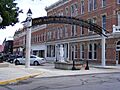
Court Avenue, looking East from South Main St.
-
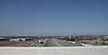
View westward from the U.S. Route 68 bridge over U.S. Route 33 on the north side of the city, near Campbell Hill.
-
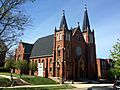
St. Patrick's Catholic Church.
-
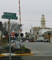
Sign declaring McKinley Street to be the "World's Shortest Street".
-
Historic Holland Theatre.
-
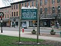
Historical marker in downtown Bellefontaine marking the site of Blue Jacket's Town

See also
 In Spanish: Bellefontaine (Ohio) para niños
