Lomas, Canóvanas, Puerto Rico facts for kids
Quick facts for kids
Lomas
|
|
|---|---|
|
Barrio
|
|

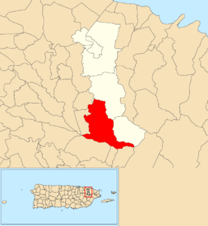
Location of Lomas within the municipality of Canóvanas shown in red
|
|
| Commonwealth | |
| Municipality | |
| Area | |
| • Total | 7.39 sq mi (19.1 km2) |
| • Land | 7.39 sq mi (19.1 km2) |
| • Water | 0.00 sq mi (0 km2) |
| Elevation | 889 ft (271 m) |
| Population
(2010)
|
|
| • Total | 5,336 |
| • Density | 722.1/sq mi (278.8/km2) |
| Source: 2010 Census | |
| Time zone | UTC−4 (AST) |
Lomas is a special kind of neighborhood, called a barrio, located in the town of Canóvanas, Puerto Rico. In 2010, about 5,336 people lived in Lomas. It's a part of the beautiful island of Puerto Rico.
| Historical population | |||
|---|---|---|---|
| Census | Pop. | %± | |
| 1980 | 4,627 | — | |
| 1990 | 5,124 | 10.7% | |
| 2000 | 5,402 | 5.4% | |
| 2010 | 5,336 | −1.2% | |
| U.S. Decennial Census 1899 (shown as 1900) 1910-1930 1930-1950 1980-2000 2010 |
|||
What are Sectors?
Barrios like Lomas are often divided into smaller areas. These smaller parts are called sectores (pronounced: sek-TOR-es), which means sectors in English.
There are different kinds of sectores, such as:
- sector (a general area)
- urbanización (a planned housing development)
- reparto (a land division)
- barriada (a neighborhood, often older)
- residencial (a residential complex)
Sectors in Lomas
The following sectors are found within the Lomas barrio:
- Parcelas Las Cuatrocientas
- Sector Las Yayas
- Sector Lomas Cole
- Sector Los Casillas
- Sector Los Fortis
- Sector Los González
- Sector Martín Rodríguez
- Sector Quebrada Prieta
See also
 In Spanish: Lomas (Canóvanas) para niños
- List of communities in Puerto Rico
- List of barrios and sectors of Canóvanas, Puerto Rico
Black History Month on Kiddle
Famous African-American Artists:
 | Emma Amos |
 | Edward Mitchell Bannister |
 | Larry D. Alexander |
 | Ernie Barnes |

All content from Kiddle encyclopedia articles (including the article images and facts) can be freely used under Attribution-ShareAlike license, unless stated otherwise. Cite this article:
Lomas, Canóvanas, Puerto Rico Facts for Kids. Kiddle Encyclopedia.

