Longsols facts for kids
Quick facts for kids
Longsols
|
|
|---|---|
 |
|
| Country | France |
| Region | Grand Est |
| Department | Aube |
| Arrondissement | Troyes |
| Canton | Arcis-sur-Aube |
| Intercommunality | Forêts, lacs, terres en Champagne |
| Area
1
|
12.61 km2 (4.87 sq mi) |
| Population
(Jan. 2019)
|
126 |
| • Density | 9.99/km2 (25.88/sq mi) |
| Time zone | UTC+01:00 (CET) |
| • Summer (DST) | UTC+02:00 (CEST) |
| INSEE/Postal code |
10206 /10240
|
| 1 French Land Register data, which excludes lakes, ponds, glaciers > 1 km2 (0.386 sq mi or 247 acres) and river estuaries. | |
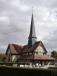
Longsols is a small place in the north-central part of France. It is known as a commune, which is like a local town or village area. Longsols is located in the Aube département. A département is a bit like a county or a region in other countries.
Contents
Discovering Longsols
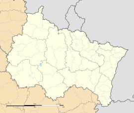
Longsols is a quiet and charming commune. It is part of the Grand Est region of France. This region is in the northeastern part of the country.
Where is Longsols Located?
Longsols is found in the Aube département. The closest big city is Troyes. Troyes is also the main city for the Aube area. Longsols is part of the Arcis-sur-Aube canton. A canton is a smaller administrative area.
How Many People Live in Longsols?
In January 2019, about 126 people lived in Longsols. This makes it a very small commune. Many communes in France are small, peaceful places.
Who is the Mayor of Longsols?
The mayor of Longsols is Jean-Luc Wagnon. He was elected to lead the commune for the term from 2014 to 2020. The mayor helps manage the local services and represents the people of Longsols.
What is a Commune?
A commune is the smallest administrative area in France. It is like a local government unit. Each commune has a mayor and a local council. They work together to make decisions for their community.
See also
 In Spanish: Longsols para niños
 | Anna J. Cooper |
 | Mary McLeod Bethune |
 | Lillie Mae Bradford |


